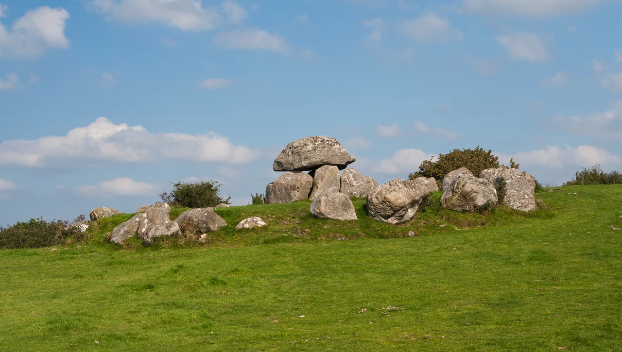

Carrowmore
The dolmens at Carrowmore were already eight hundred years old when the first stones of Newgrange were laid. They were two thousand years old when the Great Pyramid of Giza was built. The thirty surviving monuments on this small plateau outside Sligo date roughly to between 3750 BC and 3000 BC, making Carrowmore one of the oldest known megalithic cemeteries in Europe. The people who raised these stones were among the first farmers on the island - descendants, ancient DNA now tells us, of a great wave of Neolithic farmers whose origin lay in Anatolia. They brought wheat, cattle, and a religion of stone. Then they buried their dead beneath the same boulders they had hauled across this plateau, and watched the rising moon do whatever it was meant to do over the central cairn.
The Great Quarter
Carrowmore - Ceathru Mhor in Irish, the great quarter - sits on a low plateau at thirty-six to fifty-nine metres above sea level on the Coolera Peninsula west of Sligo town. Thirty monuments survive today. Another twenty-five have been destroyed since 1800 by quarrying and field clearance. The complex measures roughly one kilometre north to south and six hundred metres east to west - a dense clustering of dolmens that makes Carrowmore one of the four great Irish passage tomb cemeteries, along with Carrowkeel, Loughcrew, and Bru na Boinne. Each satellite tomb consists of five upright stones bearing a roughly conical capstone, the chamber pentagonal beneath, the whole structure encircled by a boulder ring of twelve to fifteen metres. Most were never covered by cairns. They have stood open to the weather, weathered but intact, for five thousand years.
Listoghil
At the high point of the plateau stands Listoghil, also called Tomb 51, the only cairn-covered monument in the cemetery. Erected around 3500 BC, it is thirty-four metres across with a distinctive box-like central chamber. The leading edge of the entrance stone bears engraved marks - the only megalithic art so far found at Carrowmore. The satellite tombs of the cemetery face toward Listoghil, suggesting it was the focal point around which the rest of the cemetery developed. When archaeologists excavated the chamber in 1996-98, they found unburned bones alongside cremations - a rare combination at Neolithic sites. Three large boulders found beside the chamber and beneath the cairn may be the remains of a destroyed earlier monument, suggesting that Listoghil itself was built over a still earlier sacred structure. The layering goes deep.
Knocknarea
Five kilometres to the west of Carrowmore rises the mountain of Knocknarea, a flat-topped limestone hill 327 metres above the sea. On its summit sits a gigantic cairn called Miosgan Medhbh - Maeve's Pile - a great unopened mound of stone that has never been excavated. Tradition associates it with Queen Maeve of Connacht, the great queen of the Tain Bo Cuailnge, said to be buried inside standing upright with her spear pointing toward Ulster. The cairn is contemporary with the later phase of Carrowmore - probably built around the same time as Listoghil. From the cemetery you look up at Knocknarea constantly. From Knocknarea you look down on Carrowmore and on the Atlantic Ocean beyond. The whole landscape was conceived as a single ritual geography. The peninsula was deliberately marked, mapped, and made sacred.
The Dynastic Lineage
In 2020, geneticists working on ancient DNA from Irish Neolithic burials made a striking discovery. A man buried in Listoghil at Carrowmore shared detectable kinship with three other individuals buried at Newgrange, at Millin Bay, and at Carrowkeel - the great megalithic sites scattered across Ireland and Northern Ireland. Stable isotope analysis showed these men had eaten a more protein-rich diet than the general Neolithic population. The findings suggest a dynastic elite - a network of related families who controlled the great ritual sites of fourth-millennium Ireland, buried in the most prestigious locations across the island. The man at Listoghil was related to the man at Newgrange. The implications for Neolithic Irish society are profound. There were hierarchies. There were lineages. There was something that looked like aristocracy, three thousand years before written history began.
The Dump and the Architectural Landscape
In 1983, Sligo County Council proposed to put a municipal landfill on a quarry site about a hundred yards from part of the Carrowmore complex. Five local residents took the case to court. The High Court ruled for the council. The Supreme Court, in 1989, reversed the decision. The judgment was a landmark: for the first time in Irish law, the court explicitly recognised the concept of an architectural landscape - the legal protection of a national monument was extended to include the surrounding area, the views, the visual coherence of the site. Carrowmore had been protected as monuments. Now its setting was protected too. The state purchased twenty-five acres in 1989-90 and developed a visitor centre in the old farmhouse. Most of the cemetery is now in public ownership. The dumping never happened. The dolmens stand in their fields.
From the Air
Carrowmore lies at 54.251 N, 8.519 W on the Coolera Peninsula immediately west of Sligo town. The nearest airport is Sligo Airport (EISG), about 5 km east. Ireland West Airport Knock (EIKN) is about 65 km south. From 2,000 feet on a clear day, the cemetery is visible as a cluster of pale boulder rings on a low green plateau, with the great cairn of Listoghil at its centre. Knocknarea Mountain rises 327 metres immediately to the west, its flat summit crowned by the unexcavated Miosgan Medhbh cairn. The combination of Carrowmore on the plain and the cairn on the summit make this one of the most photographable archaeological landscapes in Ireland.
Nearby Stories
- Killala 5.5 km away
- Ballaghaderreen 7.4 km away
- Townlands of Kilcommon 10 km away
- River Shannon 11 km away
- Monastery of Mohill-Manchan 15 km away
- Pettigo 18 km away
- Killybegs 19 km away
- RMS Empress of Britain (1930) 97 km away