
Castlefield
Manchester was here before Manchester. On a bluff of deep-red Collyhurst sandstone where the River Medlock joins the Irwell, the Romans built a fort called Mamucium around the year 79. They held it, more or less, until the mid-third century. The civilian settlement that grew up beside it was called Aldport. Then, fourteen centuries later, on this same patch of ground, the Industrial Revolution arrived by canal. Castlefield - bounded by the Irwell, Quay Street, Deansgate, and Chester Road - is the conservation area where Manchester became Manchester twice: once under Roman command, and once under the Duke of Bridgewater's coal.
Mamucium
The fort sat on a defensible sandstone outcrop where two rivers met. It guarded the Roman road between Deva Victrix - modern Chester - and Eboracum, modern York, with a branch road heading north to Bremetennacum, now Ribchester. Built first from turf and timber, demolished around 140, rebuilt around 160, the fort underwent a third reconstruction around the year 200 when its walls were faced in stone. A garrison of roughly five hundred auxiliary infantry held it. A civilian vicus grew alongside, with traders and soldiers' families, including a small industrial estate where iron was worked. Archaeologists have found two altars and possible evidence of a temple of Mithras. A Roman word square discovered in the 1970s may be one of the earliest pieces of evidence for Christianity in Britain. The reconstructed north gate of the fort still stands here, freely open to the public, where commuters cross to work.
The Duke's Canal
In July 1761, the Bridgewater Canal arrived at Castlefield - the world's first true industrial canal, commissioned by Francis Egerton, the third Duke of Bridgewater, to bring coal from his mines at Worsley into the centre of Manchester. James Brindley engineered it. The price of coal in the city dropped by half almost immediately. The Industrial Revolution is often dated from this moment, in this place. The Rochdale Canal joined the Bridgewater at Castlefield at Duke's Lock - Lock 92 - in 1804, the first canal to cross the Pennines, fed by the reservoir at Hollingworth Lake. James Brindley built a peculiar circular overflow weir, the Giant's Basin, still visible today as a seven-metre-deep, seven-metre-wide sump crossed by an iron footbridge. Grade II listed warehouses - the Merchant's, the Middle - survive from the early nineteenth century, when Castlefield was Manchester's main inland port.
The First Passenger Railway
On 15 September 1830, the Liverpool and Manchester Railway opened with George Stephenson's locomotives running on rails, carrying passengers - not coal, passengers - for the first time anywhere in the world. The Liverpool Road station at Castlefield was its Manchester terminus. The booking hall on Liverpool Road still stands. It is the oldest mainline railway station in the world. Separate stairs led up to separate waiting rooms for first and second class - the inventors of the modern railway also invented modern social segregation by ticket. A sundial over the first-class entrance still exists; until 1847, Manchester used local solar time, not the railway time that the rest of the country was adopting. The adjoining 1830 warehouse was built in just four months by David Bellhouse Junior. The station closed to passengers on 4 May 1844 when the line was extended to Victoria. It is now the Science and Industry Museum, sold by the railway company to a conservation group for one pound.
Viaducts and Regeneration
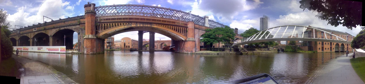
By the late nineteenth century, four enormous railway viaducts crossed the canal basin. The 1849 cast-iron viaduct, designed by William Baker for the Manchester South Junction and Altrincham Railway, has six cast-iron ribs each bolted from five pieces. The 1877 Cornbrook viaduct, refurbished in 1990 to 1991, now carries Metrolink trams to the Airport, Altrincham, and Eccles. The 1894 Great Northern viaduct served the trans-shipment warehouse on Deansgate. By the 1970s the basin had become derelict. The area was designated Britain's first Urban Heritage Park in 1982. Forty million pounds of public-sector funding flowed in. The Merchants' Warehouse - rebuilt by local entrepreneur Jim Ramsbottom after a 1971 fire - became offices. The Whitby and Bird Merchant's Bridge of 1996, with its 13 hangers suspending a curved deck from a leaning steel arch, gestures back to Santiago Calatrava. Granada Television's studios sit at the edge of the basin. Castlefield Bowl hosts summer concerts. Two thousand years of Manchester history lie under a square mile of red sandstone.
From the Air
Located at 53.475 degrees north, 2.255 degrees west, in south-west Manchester city centre, west of Deansgate and north of Chester Road. The Castlefield basin is a distinctive cluster of canal arms, brick viaducts, and converted warehouses immediately south of the Beetham Tower (47 storeys, a key landmark). Manchester Airport (EGCC) is 7 miles south-south-east. Manchester City Airport (Barton, EGCB) is 5 miles west-north-west. Recommended viewing altitude is 2,000 to 3,500 feet AGL given Manchester's busy controlled airspace; check Manchester CTR boundaries before entering.
Nearby Stories
- National Science and Media Museum 0.2 km away
- Jodrell Bank Observatory 3.2 km away
- Siege of Lathom House 5.6 km away
- Chester Zoo 6.2 km away
- Whalley Abbey 8.9 km away
- Haddon Hall 10 km away
- Wentworth Castle 16 km away
- Blackpool 16 km away