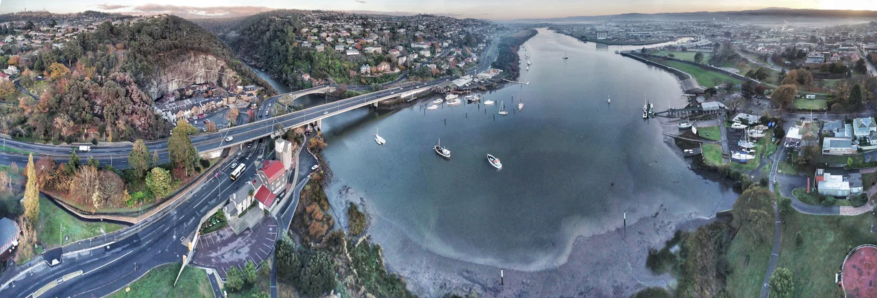

Cataract Gorge
Most cities keep their wild places at arm's length. Launceston keeps one within strolling distance of its shops. Just a kilometre and a half from the city centre, the South Esk River finishes its long journey across northern Tasmania by carving straight through a rampart of dolerite, and the result is the Cataract Gorge: cliffs, rapids, and a deep green basin where ferns drip and peacocks wander, all close enough to walk to on a lunch break. After heavy rain the river roars through in full flood; on a still summer day it sits glassy and inviting. The contrast is the whole point.
Carved at a Crossroads of Faults
The basin at the heart of the gorge has bred local legends. Some swore it was bottomless; others said it was a drowned volcanic plug, or that a submarine sent down in the 1960s ran out of cable before finding the floor. The truth is more elegant than the myths. The First Basin sits exactly where two geological faults cross, the Basin Road Fault and a second running roughly at right angles, the line the South Esk now follows. Where the faults intersect, the hard dolerite is shattered and easily worn away, so the river gouged out a bowl. Far from bottomless, it was measured in 2016 at a maximum depth of 20.5 metres. The romance survives anyway; a place this dramatic deserves a few tall tales.
The Longest Span in the World
Strung high above the First Basin is the gorge's most improbable feature: a chairlift whose central span, 308 metres, is believed to be the longest single chairlift span anywhere on Earth. Built in 1972, the whole line stretches 457 metres, carrying visitors over the water in about ten minutes with nothing but air and a long drop beneath their feet. It is not the only way across. A graceful suspension bridge, built in 1904, links the two banks, and an inclinator climbs the slope below. The southern side, the First Basin, offers a swimming pool, cafes and open lawns; the northern side, the Cliff Grounds, is a landscaped Victorian garden of tree ferns and exotic plants where peacocks have the run of the place.
Light for a City
The gorge did more than charm Victorian Launceston; it powered it. In 1893 the city council commissioned a power station upstream at Duck Reach, and by 1895 it was sending electricity into the streets, helping make Launceston the first Australian city lit by hydroelectricity. Floods tore the station away in 1929, and it was rebuilt, then retired in 1955 once the Trevallyn Dam upstream took over the work. Today the old Duck Reach building survives as an interpretation centre, a stone monument to a moment when a Tasmanian river first turned night into day for a whole city. The dam also reshaped the gorge itself, flooding the uppermost of a series of smaller basins that once stepped down toward the First Basin.
Whitewater and a Walk Through Time
The river that lit the city still has teeth. Below Trevallyn, the South Esk runs as recognised whitewater, world-class kayaking water that draws a race here most years in late January. For those who prefer dry feet, the King's Bridge to Cataract Walk traces the northern bank, built by volunteers in the 1890s, its original toll house still standing near King's Bridge where pedestrians once paid to enter. Gentler pleasures abound too: a boat cruise glides through the accessible lower reach, and a cable hang-gliding ride soars some two hundred metres out from a clifftop for those who want the gorge from the air. At its lower mouth the South Esk slides under King's Bridge and pours into the Tamar. For nearly a century that bridge was the only crossing leading north out of Launceston, a single thread tying the growing city to everything beyond it, with the gorge thundering quietly just upstream until the newer Paterson Bridge opened alongside it in 1973.
From the Air
Cataract Gorge lies at 41.45 degrees south, 147.12 degrees east, on the southwestern edge of Launceston where the South Esk River meets the Tamar. From the air it reads as a sharp, dark notch cutting into the city's western suburbs, the river threading between cliff walls before joining the broad Tamar estuary that runs northwest toward Bass Strait. Use the Trevallyn Dam and Lake Trevallyn just upstream as a navigation marker, and the dense grid of central Launceston just to the northeast. Launceston Airport (YMLT/LST) sits about 13 nm southeast. The Tamar Valley is prone to morning fog and thermal inversions, so a clear afternoon offers the cleanest line of sight down the gorge and along the river.
Nearby Stories
- Van Diemen's Land 39 km away
- Cradle Mountain-Lake St Clair National Park 59 km away
- Overland Track 61 km away
- Bay of Fires 62 km away
- Freycinet National Park 68 km away
- Stanley (Tasmania) 117 km away
- Wybalenna Aboriginal Establishment 127 km away
- Flinders Island 151 km away