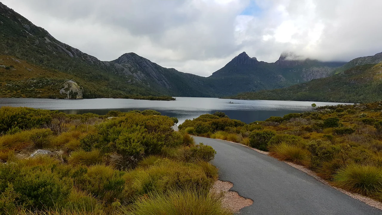

Cradle Mountain-Lake St Clair National Park
On 4 January 1910, an Austrian botanist named Gustav Weindorfer stood on the summit of Cradle Mountain with his wife Kate, looked out over the jagged ridgeline and the lakes scattered below, and made a promise. "This must be a national park for the people, for all time," he said. It took twelve years, a chalet he built by hand and called Waldheim, meaning home in the forest, and a lifetime of campaigning, but the reserve was finally gazetted in 1922. Today the park sprawls across the alpine heart of Tasmania, stretching from Cradle Mountain in the north to deep, cold Lake St Clair in the south, two great destinations linked by some of the most pristine wilderness left on the planet.
The Cradle and Its Name
Cradle Mountain does not soften with familiarity. Its dolerite ridge rises in broken columns above Dove Lake, the most photographed scene in Tasmania, where a small boatshed of pencil pine sits at the water's edge with the mountain reflected behind it. The peak reaches 1,545 metres, the sixth-highest in Tasmania, and surveyor Joseph Fossey gave it its name back in 1827, thinking the cleft profile between the summit and Little Horn resembled a gold miner's cradle, the rocking trough used to sift metal from river gravel. The dolerite itself was forced up through the crust in the Jurassic and later carved by Ice Age glaciers, which gouged the cirques and left the chain of dark tarns that make this landscape look both ancient and freshly broken.
Ancient and Endemic
This is a refuge of living fossils. The vegetation ranges from rainforest to open buttongrass moorland, and threaded through it are conifers found nowhere else on Earth: King Billy pine, pencil pine, and the deciduous beech, Nothofagus gunnii, whose leaves blaze gold and rust for a few short weeks each autumn in the only winter-deciduous display native to Australia. The forests are remnants of Gondwana, the supercontinent that joined Tasmania to Antarctica and South America before the land masses drifted apart. The park is also home to the full cast of Tasmanian wildlife: wombats grazing the moorlands at dusk, Bennett's wallabies and pademelons, and, for the lucky and the patient, platypus, echidnas, quolls, and the Tasmanian devil itself.
Weather That Writes the Rules
There is a local saying that it rains here nine days out of ten, and it is not far from the truth. The climate is wildly unpredictable and changes within minutes: sun, then a sudden curtain of fine rain blown sideways, then sun again. Snow can fall in the middle of summer, a genuine rarity for Australia, and the wind makes umbrellas useless. The cold sits deeper than the latitude suggests. Visitors are told to carry wet-weather gear in every season, because the mountain makes its own weather and shares it without warning. That volatility is part of the park's character; the same storms that drench the slopes feed the lakes, the rainforest, and the waterfalls that thread the short walks near Dove Lake.
Two Ends, One Wilderness
The park has two front doors, and they are a long way apart. In the north, Cradle Mountain offers everything from the gentle, half-hour Enchanted Walk to the steep, chain-assisted scramble to Marion's Lookout and the full-day summit climb. In the south lies Lake St Clair, Australia's deepest natural freshwater lake, carved by glaciers and ringed by peaks including Mount Olympus and Mount Ida. A ferry crosses the lake between Cynthia Bay and Narcissus, often carrying walkers at the end of their journey. Between the two ends rise the park's great mountains, among them Mount Ossa, at 1,617 metres the highest point in Tasmania. To cross from one end to the other on foot is to walk the world-famous Overland Track, but you do not need to walk for days to feel the scale of this place. A single afternoon at Dove Lake is enough.
From the Air
Cradle Mountain-Lake St Clair National Park occupies the alpine Central Highlands of Tasmania, with Cradle Mountain in the north near 41.69 S, 145.95 E and Lake St Clair anchoring the south. The park's centre lies around 41.83 S, 145.92 E. From the air, navigate by the major peaks: Cradle Mountain's distinctive notched dolerite ridge (1,545 m) above Dove Lake in the north, Mount Ossa (1,617 m, Tasmania's highest) in the centre, and the long glacial trench of Lake St Clair to the south. Recommended viewing altitude 6,000 to 9,000 ft AGL to clear the highland peaks. Nearest airfields are at Devonport (YDPO) and Wynyard/Burnie (YWYY) to the north, with Launceston (YMLT) to the northeast and Hobart (YMHB) to the southeast. Weather is among the most volatile in Australia: frequent cloud, rain, high winds, and snow possible in any month, so clear flying windows are short and unreliable.
Nearby Stories
- Mount Bischoff 7.9 km away
- West Coast Wilderness Railway 16 km away
- Beaconsfield Mine Collapse 36 km away
- Mount Lyell (Tasmania) 38 km away
- Van Diemen's Land 43 km away
- Strahan 49 km away
- Cataract Gorge 87 km away
- Museum of Old and New Art 104 km away