Dollart
On a still afternoon, when the tide is out and the mudflats stretch for kilometers toward Germany, the people of Reiderland will tell you that you can hear the bells ringing under the water. The story has been passed down for five hundred years. It refers to a specific event: the Cosmas and Damian flood of 26 September 1509, when a storm surge driven up the Ems estuary punched through the medieval dikes and drove the sea so far inland that, when it finally pulled back, twenty-four villages had simply ceased to exist. Earlier scholarship blamed a single catastrophic flood in 1277 or the Saint Marcellus flood of 1362 for the entire Dollart, but the truth was slower and crueler — peat dug for fuel, soil sinking, repeated surges over two centuries — and 1509 was just the loudest blow. By 1520, the bay covered an estimated 340 square kilometers. The Premonstratensian monastery of Palmar was gone. The villages of Oosterreide and Westerreide were gone. Fletum and Torum were gone. And in the silence afterward, somewhere offshore, the bells.
Where the Name Comes From
Late fifteenth-century scribes from Aduard Abbey and the Groningen scholar Wilhelmus Frederici both noted the bay's name as Dollard or Dullert. The etymology is uncertain, and that has not stopped people guessing. One school traces it to Middle Dutch dole — a pit, a pool, a hole — perhaps meaning excavated water, perhaps grave of the dead. Another school, more romantic, hears in the name the Dutch phrase dolle aard, meaning furious nature, a reference to the sea's temper in this estuary. Around 1600 the East Frisian chronicler Ubbo Emmius wrote that the bay took its name a fluctuum rabie — from the rage of its waves. Whichever theory is correct, the bay's reputation as an angry place predates almost every other thing said about it.
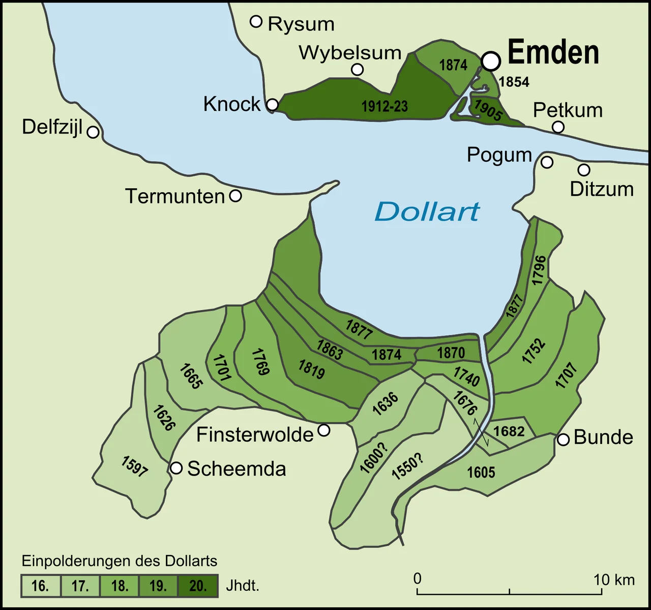
Reclaiming What the Sea Took
Almost as soon as the floods stopped expanding the Dollart, both Dutch and German farmers began pushing it back. The technique was the same on both sides of the border: build a dike just inside the salt marsh, wait for sediment to raise the protected land, dig drainage ditches, plant grass, then grain. The German Kanalpolder was sealed off in 1877. The Dutch Johannes Kerkhovenpolder followed in 1878, the Carel Coenraadpolder in 1924, and Polder Breebaart was completed in 1979. Roughly two-thirds of the inundated medieval landscape has been recovered. Polder Breebaart took the process in a deliberate reverse direction — opened in 2001 as the first managed inland tidal area in the Netherlands, a small piece of farmland deliberately given back to the sea for the sake of the migratory birds that no longer had enough mudflat to feed on.
Birds and Mud
What remains of the bay today is one of the most important migration stops on the East Atlantic Flyway. About 100 square kilometers of water and tidal flat sit at the head of the Ems estuary, more than half of it dry at low tide and rich with the diatoms and worms that long-distance migrants need. The Dutch sector alone is over 9,000 hectares of open tidal area. Designated as a Ramsar site in 1976, included in the Wadden Sea World Heritage inscription of 2009, and managed by Natuurmonumenten and Het Groninger Landschap, the Dollart now feeds millions of waders and waterfowl each year. Persistent silt in the water remains the chronic ecological problem — concentrations are high enough to limit light penetration — and a German-Dutch sediment management agreement has been working for years to bring it down.
The Border That Isn't
The maritime border through the Dollart has never been formally drawn. Both the Netherlands and Germany have positions on where it ought to be, and those positions disagree. Rather than fight it out, the two countries signed the Ems-Dollart Treaty in 1960 to organize navigation, fisheries and administration in the estuary without resolving sovereignty. The arrangement worked quietly until 2011, when Germany permitted the Riffgat offshore wind farm inside the disputed zone and the question became practical again. A second bilateral agreement in October 2014 set out a functional line for managing the territorial sea between 3 and 12 nautical miles, and was widely misreported as ending the dispute. It does no such thing — the treaty's own text explicitly preserves both parties' claims. Where exactly Germany ends and the Netherlands begins, in the water between Emden and Delfzijl, remains officially unsettled in 2026.
The Bird Hide on the Dike
Near Nieuwe Statenzijl, on the Dutch side, a wooden tower called the Kiekkaaste stands outside the sea dike — the only bird hide in the Netherlands positioned beyond the country's coastal defense line. From its observation deck the entire Dollart opens out: salt marsh in the foreground, the Punt van Reide headland to the west, the German shore vanishing into haze across the bay. Beyond the hide runs the cross-border Internationale Dollard Route, a cycling network linking the small ports of Ditzum, Emden and Delfzijl. The Dollarthafen, a deep-water port proposed for Emden in the 1970s and 1980s, was abandoned in 1988 on economic grounds — and the cross-border environmental campaign against it became one of the early successes of European nature politics. The bells, somewhere out there, are still ringing.
From the Air
Centered at approximately 53.29°N, 7.16°E in the southeastern Wadden Sea, straddling the Germany-Netherlands border. The Dollart appears as a roughly circular bay about 9 km north-to-south, opening northwest into the Ems estuary. The German port of Emden sits on its northern shore; Delfzijl and Eemshaven lie to the northwest on the Dutch side. At low tide the bay shows extensive light-colored mudflats — over half its surface dries out. The reclamation polders on both sides are visible as a step-pattern of dikes and rectangular fields. Nearest airports: Bremen (EDDW, ~110 km southeast), Groningen Eelde (EHGG, ~55 km west). Recommended viewing altitude: 3,000–6,000 ft AGL to see the whole estuarine system.
Nearby Stories
- Tynaarlo 5.3 km away
- Organ in the Jacobikerk at Uithuizen 6.4 km away
- Bourtange 8.9 km away
- Norderney Airport 11 km away
- Razing of Friesoythe 11 km away
- Harle (gat) 19 km away
- Lordship of Gödens 22 km away
- Alpha Ventus Offshore Wind Farm 45 km away