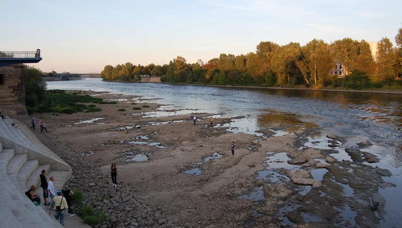

Domfelsen
Magdeburgers once read the harvest off the river. If you could walk out onto the rocks below the cathedral, the Elbe was low; if the Elbe was low the season had been dry; and if the season had been dry the grain would be short. So the outcrop picked up a second name. Officially it is the Domfelsen, the cathedral rocks. Locally it was the Hungerfelsen — the hunger rocks — a landmark that only shows itself in the years you would rather it stayed hidden. It is an odd sort of monument: a low grey ledge of sandstone in the middle of a working river, easy to miss from the promenade above, and, for generations, wrongly credited as the reason there is a city standing over it at all.
Three Hundred Million Years Down
The rock is mostly sandstone with a little siltstone in it, and it belongs to the Rotliegend, laid down in the Lower Permian — somewhere close to three hundred million years ago, long before anything resembling the Elbe existed to cut through it. What surfaces in the river is the far end of the Flechtingen Hills, a low upland northwest of the city. Those hills do not stop at Magdeburg so much as duck under it, running on beneath the streets under a thin skin of Quaternary sand and gravel that hides them completely. The Domfelsen is where the old bedrock comes back up for air. Everything else about Magdeburg's ground is loose river deposit, workable and unreliable; this one ledge is not.
Why the City Is Where It Is
A river that can be crossed on foot decides where people settle, and for a long time the popular explanation for Magdeburg's location was that the outcrop gave the Elbe a ford here. Modern hydrology tells a different story. In the early Middle Ages the Elbe ran at least two metres higher than it does today, so the Domfelsen was very likely still buried under sediment — probably not exposed until the nineteenth century, when the riverbed eroded down to it. Historians now consider a ford here unlikely and think early crossings were made by ferry instead. The rock cannot have decided where Magdeburg began; it only broke the surface long after the city already had. It seemed, for a long time, to have decided a second question too: legend held that the builders had set the cathedral directly on the rock for a firmer foundation than the surrounding land could offer. Geotechnical surveys carried out between 2006 and 2010 put that legend to rest as well — the cathedral in fact stands on tertiary greensand and layers of sand and clay that cover the rock, not on the Domfelsen itself. The rocks did not put the city or the cathedral where they are. They only kept getting credit for it.
The Narrows
The Domfelsen is still doing hydraulic work. It pinches the channel, and a pinched channel runs faster, so the current below the cathedral is noticeably quicker than the Elbe manages either side of it. Even at high water there is only one way down: hard against the eastern bank. Commercial vessels are not permitted to cross the river at this point, and traffic through the constriction is regulated remotely by a light system rather than left to judgement. Going the other way is harder still — underpowered motor barges often cannot push upstream here at all without a tug on the head. The same narrowing that complicates navigation shapes the river's ecology, giving the Elbe a stretch of fast, stony, oxygenated water where it would otherwise be slow and silty.
Down the Steps at Low Water
When the water drops, the rocks emerge along the west bank and you can walk out onto them from the shore. A staircase built in the summer of 2007 made the descent a great deal easier than scrambling, and in a dry year the ledge fills with people picking their way across bare Permian sandstone in the middle of a city. Above them on the landward side stand the remains of the Südliches Eisenbahnfestungstor, the southern railway gate of Magdeburg's old fortress ring — a fragment of the nineteenth-century Prussian defences that once wrapped the whole town. It makes for a strange stack of timescales in a few vertical metres: a Permian reef, a medieval crossing point, a fortress gate, and a set of modern steps.
The Argument About Removing It
Because the rocks obstruct shipping, the authorities responsible for navigation have proposed getting rid of them more than once, most seriously after the catastrophic Elbe flood of 2002. A citizens' initiative called Pro Elbe fought the plan on hydrological grounds: removing the ledge, they argued, would trigger bed erosion reaching upstream as far as the mouth of the Saale, lowering the water levels that the floodplain's wetlands depend on. The plan was quietly dropped after 2002, and by 2019 shipping traffic through the narrows had fallen enough that the bottleneck barely registered as a practical problem. One old worry turned out to rest on a false premise rather than a real risk: people had long feared that disturbing the Domfelsen would undermine Magdeburg Cathedral, but the 2006–2010 surveys that settled the ford question also showed the cathedral was never resting on the rock to begin with — so there was nothing there to undermine. The rock is still there, and in the dry years the city can still read the harvest off it.
From the Air
The Domfelsen lies at 52.1227°N, 11.6367°E, in the Elbe directly below Magdeburg Cathedral in the centre of the city. Navigate to the cathedral first — its two Gothic west towers are the tallest thing on the west bank and visible for a long way across the flat Börde farmland — then look immediately east into the river. From 1,000–2,000 ft AGL in a dry season you will see the giveaway: a pale broken shelf along the western side of the channel and a visible acceleration of the water past it, with the shipping line pushed hard over toward the east bank. In high water there is nothing to see but a change in the surface texture. Magdeburg–Cochstedt (EDBC) is about 37 km southwest; Leipzig/Halle (EDDP) lies roughly 90 km south-southeast and Berlin Brandenburg (EDDB) about 130 km east. Late summer and autumn give the best odds of exposed rock; spring meltwater hides it entirely.
Nearby Stories
- Quedlinburg 10 km away
- Inner German Border 13 km away
- Helmstedt–Marienborn border crossing 16 km away
- Jerichow Monastery 21 km away
- Bauhaus Dessau 31 km away
- Autostadt 32 km away
- All Saints' Church, Wittenberg 36 km away
- Lichtenburg Concentration Camp 48 km away