
Dover
On a clear day from the cliffs above the harbour, you can see France. The coast of Cap Gris Nez is thirty-four kilometres across the Strait of Dover - the narrowest pinch of the English Channel - and the chalk on the French side belongs to the same geological formation as the chalk under your feet. About four hundred and fifty thousand years ago this was not a strait. A ridge of chalk and clay called the Weald-Artois Anticline connected Britain to Europe, and a vast freshwater lake spread north of it, dammed by ice. When that ice dam failed, the floodwater carved through the ridge in a catastrophic outburst. Britain became an island. Dover became, ever after, the place where you came to look at the place you had just been cut off from.
Portus Dubris
The Romans called it Dubris and built a road from here to Canterbury and on to London - Watling Street, still buried under the modern A2. They put up two lighthouses to guide their galleys into the harbour; one of them, on the chalk headland beside the castle, is still standing and is the tallest surviving Roman structure in Britain. They built a fortified port, a villa with painted walls, baths, communications - everything Rome needed for the closest landing point to the continent. The name itself comes from older still: dwfr, the Brythonic word for water, surviving in modern Welsh and Breton, attached to the River Dour that runs through the town. Stone Age people lived here. Iron Age people lived here. In 1992, archaeologists pulled a Bronze Age boat from six metres of mud - radiocarbon dated to roughly 1550 BC, one of the oldest seaworthy vessels ever found, proof that this crossing has been busy for at least thirty-six centuries.
The Key of England
Dover Castle climbs the eastern headland - one of the largest castles in England, founded by William the Conqueror in 1066, expanded under Henry II, King John, and Henry III until its curtain walls touch the cliff edge. It has earned its old nickname, the Key of England, by being besieged and assaulted in nearly every century since. In 1216, Louis VIII of France landed his army on Dover's beach hoping to depose Henry III. Henry's bowmen waited on the white cliffs above; his cavalry charged the French on the shingle below. The French slaughtered the cavalry, climbed the cliffs, scattered the bowmen, and held the town for three months before being forced out. In 1642, during the Civil War, the townspeople climbed the cliffs at night and surprised the royalist garrison inside the castle - a symbolic moment that gave Parliament the harbour. During the Napoleonic Wars, engineers carved a warren of tunnels into the chalk beneath the castle to barrack two thousand extra soldiers. During the Cold War, those same tunnels became a regional seat of government, ready to coordinate British defence in the event of Soviet invasion. The Soviet 1:10,000 city plan of Dover, drawn in 1974, carefully omits them.
Bluebirds and Ferries
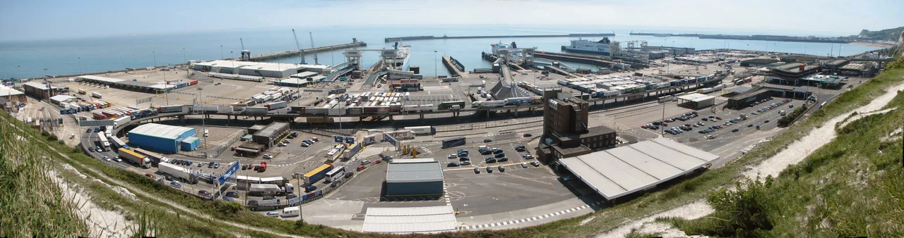
By 2019, more than 368,000 people visited Dover Castle in a single year. The Port of Dover provides most of the rest of the town's employment - one of the busiest ferry terminals in Europe, with thirteen daily P&O sailings to Calais, fourteen DFDS, fourteen Irish Ferries. The Strait of Dover is the busiest shipping lane in the world, and the Channel Navigation Information Service at MRCC Dover runs the traffic separation scheme that keeps Calais-bound ferries from colliding with the constant procession of container ships. In the late twentieth century, the harbour lost services it once depended on - SeaFrance shut down in 2012, Hoverspeed in 2005, SpeedFerries in 2008. The town has been reinventing itself since: a 500-metre pier west of the harbour opened in 2019 as part of a £330 million investment; a high-speed rail link puts London 55 minutes away. Vera Lynn sang about bluebirds over the white cliffs in 1942 even though bluebirds aren't native to Britain - she probably meant swallows or house martins, the birds that actually cross the Channel twice a year. She lived to see her hundredth birthday in 2017, and led the campaign to buy a stretch of the cliffs back from possible development. The campaign hit its target in three weeks.
Shakespeare, Arnold, and the Cliffs
Writers have always known what Dover is for. Shakespeare set part of King Lear here - the scene where Edgar leads his blinded father to the edge of the cliff is the reason Shakespeare Cliff has its name, and the line 'halfway down hangs one that gathers samphire; dreadful trade' is why the country park below it is called Samphire Hoe. Charles Dickens wrote Dover into A Tale of Two Cities. Matthew Arnold stood at this coast in 1851 and wrote Dover Beach - 'the cliffs of England stand, glimmering and vast, out in the tranquil bay' - and one hundred and seventy years later the singer Baby Queen filmed a music video at Samphire Hoe inspired by his poem. Russell Hoban reimagined Dover as 'Do It Over' in the post-apocalyptic novel Riddley Walker, after the bombs have fallen. The town keeps absorbing what people make of it. The Blériot Memorial marks the exact spot above the cliffs where Louis Blériot crash-landed his monoplane in 1909, ending the first cross-channel flight - the outline of his aircraft picked out in granite setts in the turf, half a kilometre from the castle. Dover is twinned with Calais. It has always been twinned with Calais. The two towns face each other across the narrowest water on the planet, watching the same ferries go back and forth, the same shipping lane, the same chalk under the same sea.
From the Air
Dover is centred on 51.128°N, 1.312°E in the south-east corner of Kent, England, where the River Dour valley meets the English Channel. From the air, look for the harbour's curving breakwaters on reclaimed land, Dover Castle high on the eastern chalk headland, and the Western Heights opposite. The White Cliffs flank the harbour for eight miles in either direction. Cap Gris Nez in France is visible 34 km southeast across the Strait. Nearest airport is London Ashford (Lydd) (EGMD) about 35 km west; Manston (EGMH) is 25 km north. Approach altitude 2,000-4,000 ft offers the best view of harbour, castle, and cliffs together.
Nearby Stories
- HMS Hermes (1898) 7.3 km away
- Herne Bay Museum and Gallery 8.5 km away
- Benenden School 9.2 km away
- Boulonnais 9.4 km away
- Priestfield Stadium 12 km away
- 1382 Dover Straits Earthquake 17 km away
- Royal Sovereign Lighthouse 21 km away
- Battle of Boulogne 28 km away