El Airo, Loja
In 2009, a coffee from the parish of El Airo in southern Ecuador placed second in the Taza Dorada - Ecuador's national coffee competition. The cooperative that grew it, APROCAIRO, represented roughly a thousand mestizo villagers in a place most Ecuadorians could not find on a map. The news meant something. El Airo sits in a valley between 1,600 and 3,200 meters above sea level in the southern province of Loja, near the Peruvian border, and for most of the twentieth century its inhabitants worked the land of absentee landlords. That they were now winning national coffee prizes represented a story about land reform, cooperative organizing, and the stubborn business of growing good beans on steep mountainsides.
The Name from the Wind
El Airo takes its name from a Spanish word for air or wind - the strong, consistent winds that sweep through this high valley gave the original Patrones the name for their hacienda, and the name stuck. Patron, in the colonial and post-colonial Latin American sense, means the moneyed landowner - and El Airo, like most of rural Loja, spent centuries as a hacienda where a small landowning family controlled thousands of hectares and hundreds of tenants. The majority of the mixed-race population worked the patrones' land through most of the twentieth century, receiving a small subsistence plot of their own in exchange for their labor. The arrangement ended not gradually but through legislation. In the 1960s, Ecuador enacted agricultural land reform, redistributing hacienda land to the workers who had been farming it. The patrones left. The people stayed.
Father Ernesto's Parish
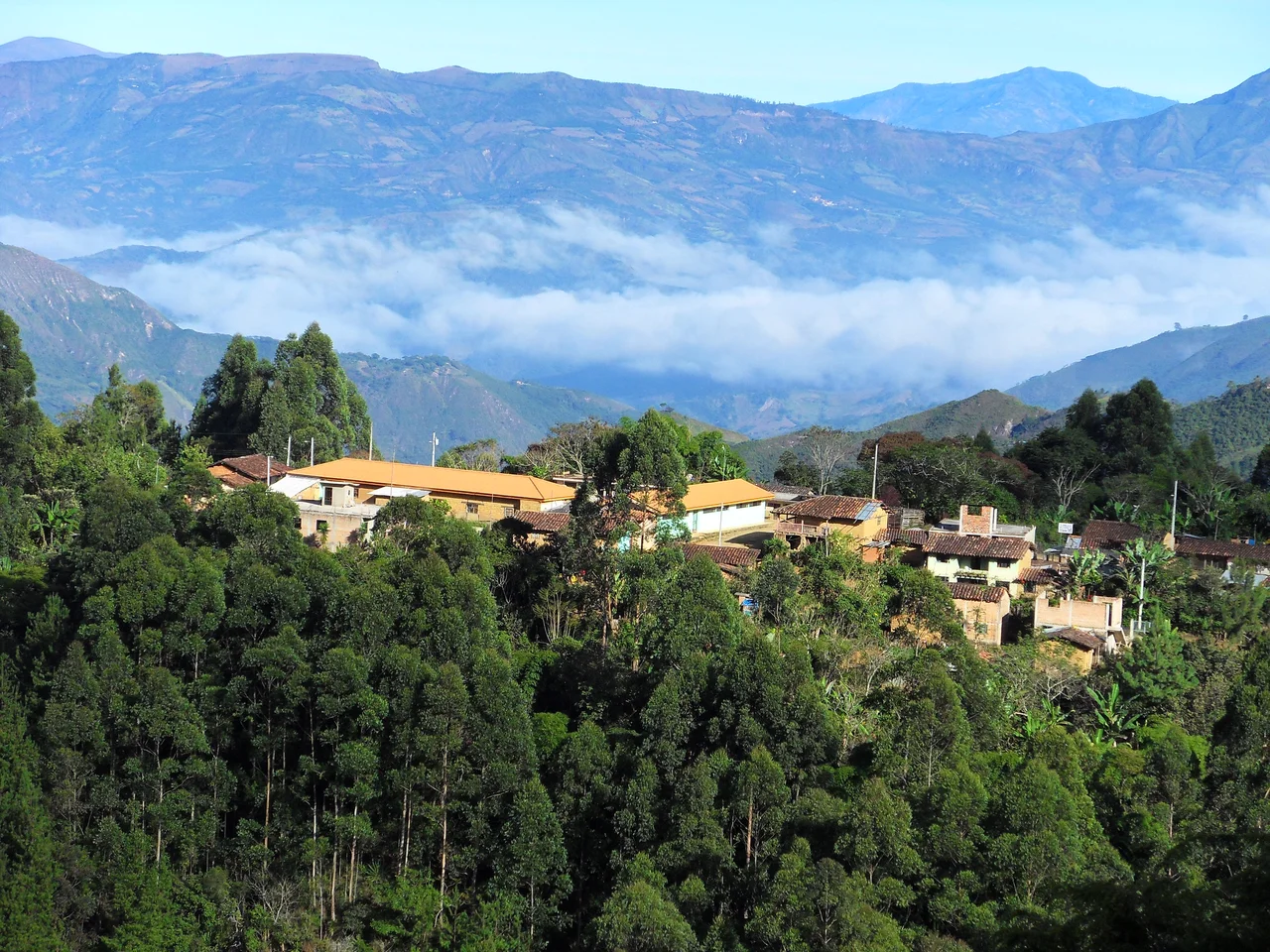
For almost three decades after land reform, El Airo existed without formal status - its residents had land, but the settlement was not yet recognized as a civil parish. The change came in 1988 when Father Ernesto Celi Roman, the local priest, began leading a political and legal effort to formally constitute El Airo as a parish within the Espindola canton. The process took four years of petitions, documentation, and official review. It concluded on August 2, 1992, when El Airo was established as a parish. On the same day, a new secondary school - Colegio Dos de Agosto, named for the founding date - was inaugurated in the community. The parish now comprises four small neighborhoods or barrios: La Guaca, the most populated and home of the parish council, plus El Tambo, El Laurel, and El Batan. The 2001 census recorded 1,093 inhabitants, 565 men and 528 women.
Coffee as Livelihood
El Airo's economy centers almost entirely on coffee, grown organically and graded highly enough to place second in the 2009 Taza Dorada competition. Families also cultivate sugar cane, yucca, bananas, and various fruits for subsistence, and most households raise chickens, pigs, and a few cuyes - the domesticated guinea pigs that remain a staple meat in the Andes. A few families keep cattle. But coffee is the cash crop. Recognizing the importance of organization in getting fair prices and improving quality, the residents of El Airo formed coffee cooperatives - most prominently APROCAIRO, the cooperative whose beans placed in the Taza Dorada. These cooperatives negotiate on behalf of member farmers, share equipment, provide technical advice on crop management, and secure the organic certifications that command higher prices on international markets. It is the kind of small-farmer cooperative model that has transformed specialty coffee economics across Latin America.
The Inca Trail Above
The highest sections of El Airo, up near 3,200 meters, lie close to the presumed route of the Inca Trail through southern Ecuador. This is not the famous Inca Trail to Machu Picchu but one of its lesser-known southern sections, the network of stone-paved roads that the Inca extended through their empire during the fifteenth and early sixteenth centuries. Stone tools and structural foundations found in the higher reaches of the parish suggest indigenous habitation long predating the arrival of the Spanish. Whether the trail above El Airo was a major highway or a local connector between Canari settlements, archaeologists have not fully established, but the physical evidence places this remote Andean valley within the orbit of pre-Columbian trade networks that linked the southern Ecuadorian highlands to the Peruvian sierra.
Waterfalls, Bears, and Paramo
El Airo sits within the boundary of Parque Nacional Yacuri, a protected area straddling the border between Ecuador and Peru. Within Yacuri, highland paramo lakes called Las Rositas form at altitudes where native grasses and polylepis trees give way to wetland ecosystems - the same paramo that feeds the rivers running through southern Ecuador. Several waterfalls drain from the high country. The most striking is El Palmo, at 2,000 meters, named for the solitary palm tree standing at the top of the falls. The rivers El Airo and Chiriacu both rise in the mountains here. The wildlife is strong: birds and butterflies in abundance, and in the highlands, occasional sightings of the spectacled bear - Tremarctos ornatus, the only bear native to South America. Some visitors come specifically to see organic coffee agriculture; others come for the hiking and the birds; a few come for the slim chance of glimpsing a spectacled bear at dusk.
One Bus a Day
El Airo is not on any standard tourist itinerary. Transport within the parish runs by foot, donkey, or motorcycle. Transport in and out consists of one bus per day, supplemented by two rancheras - the open-air bus-truck combinations common in rural Andean Ecuador, where passengers ride standing or sitting on benches in the open back. The mobile phone network reached the parish only recently, though radio and television signals have come through for longer, including Peruvian channels that cross the border easily in this mountainous terrain. Religion is Catholic, with annual festivals celebrating the Cross in May and the patron saint San Vicente Ferrer on the first Saturday of June. Local crafts include decorative pillows, handbags, doilies, and traditional satchels - some sized for loading onto donkeys for heavy cargo, some made for lighter shoulder use. The satchels are the most practical of the crafts, still used for their original purpose in a place where a donkey remains a serious piece of household equipment.
From the Air
El Airo at 4.48 S, 79.39 W in southern Ecuador's Loja Province, near the Peruvian border. Altitude range 1,600 to 3,200 meters, with settlement typically around 2,000-2,500 meters. Nearest airports: Ciudad de Catamayo (SECA/LOH) serving Loja about 75 km northwest; Piura Capitan FAP Guillermo Concha Iberico (SPUR/PIU) in Peru further south. Terrain difficult for small aircraft - Andean ridges run north-south with few emergency landing options. Recommended cruise altitudes 12,000 feet minimum for safe terrain separation. Morning flights preferred; afternoon orographic buildups common.
Nearby Stories
- Loja, Ecuador 27 km away
- Alamor 33 km away
- Tambogrande 63 km away
- Puyango Petrified Forest 68 km away
- Department of Piura 128 km away
- Marañón Dry Forests 133 km away
- Borja, Peru 134 km away
- Cueva de los Tayos 143 km away