
Eresburg
The Frankish army had allowed itself two or three days to finish wrecking the shrine, and partway through it ran out of water. What happened next is recorded in the Royal Frankish Annals as divine grace: at midday, while the whole army rested, a stream near the camp suddenly ran full, and there was enough for every man and beast. It is the sort of detail that finds its way into a chronicle when a campaign needs justifying. The year was 772. The shrine was the Irminsul, a pillar or tree standing at the centre of Saxon religion. And the fortress Charlemagne had just taken was the Eresburg, a hill castle on a flat-topped rise 130 to 150 metres above the river Diemel - the largest Saxon refuge castle known, and the opening move in thirty years of war.
A Thousand Years Before the Franks
People had been using this hill for a very long time before anyone wrote about it. Pottery from the Michelsberg culture has come out of the ground here, and excavations near the present collegiate church have turned up ditches, ramparts and post holes whose radiocarbon dates put them in the pre-Roman Iron Age; the timbers themselves came from trees felled between about 420 and 370 BC. The site chose itself. A table hill above a river valley, on the extreme southern edge of the Saxon region of Engern where it met the Duchy of Franconia, is a place you fortify if you have anything worth keeping. Nineteenth-century scholars, working backwards from Roman literature, wanted it to be the stronghold of the Cherusci prince Segestes, and told a good story about his daughter Thusnelda being held captive here. There is nothing in the record to support it.
The Sentence That Will Not Settle
Whether the Irminsul actually stood on the Eresburg is a question that turns on the grammar of a single line. The Annales Petaviani record that Charlemagne "conquered the Eresburg and found the place which is called Ermensul, and set these places on fire." He came to the place called Ermensul - pervenit ad locum - which reads like arriving somewhere else. The writer calls the fortress Erisburgo, not Ermensula, keeping the two names apart. And the burning is plural: et succendit ea loca, he set these places on fire, as though the army moved from one to the other. Other accounts have Charlemagne camped near the Bullerborn, an intermittent spring near Altenbeken, before going on to destroy the shrine; Jacob Grimm put the site some fifteen miles off in the Teutoburg Forest, noting that the old name Osning may have meant holy wood. The likeliest answer is that the question is wrong. There was probably more than one Irminsul.
A Church on the Temple Floor
Conquest was the first half of the strategy; the second was slower and more permanent. In 779 Charlemagne sent Sturmius, the abbot of Fulda, into this country as a missionary and directed him to this place in particular. In the winter of 784 into 785 the king based himself at the Eresburg - a long way from Aachen, in hostile territory, in the cold - and had a church built, most likely on the ground where the Saxon temple had stood. Building the new religion on the exact footprint of the old one was not subtlety, it was the message. Tradition holds that Pope Leo III broke his journey here in 799 on the way to Paderborn, where he would meet Charlemagne and set in motion the imperial coronation of the following year. Within two generations the hill had gone from the far side of the frontier to a waypoint on the road to an empire.
915: A Bad Year on the Hill
Border positions do not stop being fought over just because the border moves. In 915 the Eresburg saw a bloody clash between the Saxon duke Henry the Fowler, soon to be king, and Conrad, the king of East Francia - a dynastic quarrel settled, as such quarrels were, with axes on a hillside. The bishop of Paderborn, Theoderic, is recorded as having taken part in the fighting personally, which tells you something about the office in the tenth century. The same year, a raiding Hungarian army defeated a German force here. Two battles on one hill in twelve months is a reasonable summary of the site's entire career: whoever wanted the Diemel valley had to come up and take this hill, and did, repeatedly.
The Village on Top
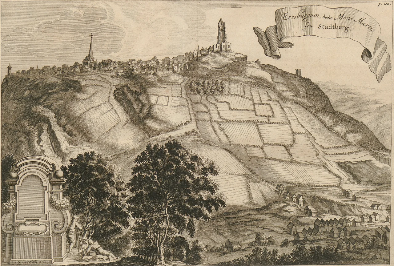
Nothing of the Saxon fortress stands. What sits on the plateau today is Obermarsberg, a village of the town of Marsberg in the Hochsauerlandkreis, reached by a climb that immediately explains why the place was chosen: the ground falls away on every side toward the Diemel, and the view runs out across rolling Westphalian and Sauerland country in all directions. The collegiate church that archaeologists dug beside occupies roughly the ground Charlemagne's church did, on roughly the ground a Saxon sanctuary did before that. In an old engraving from 1646 the hill appears under bombardment, still worth fighting over in the Thirty Years' War, nearly nine centuries after the Franks arrived. Some hills never stop being useful.
From the Air
The Eresburg plateau lies at 51.450N, 8.853E, occupied today by the village of Obermarsberg above the town of Marsberg, on the boundary between Westphalia and northern Hesse. It is one of the more satisfying sites in the region to identify from the air, because the geography does the work: a distinct flat-topped table hill standing 130-150 m above the Diemel valley, with the river curling round its foot and the church on the summit acting as a marker. Best appreciated at 1,500-3,000 ft on a low sun angle, when the scarp edges throw shadow and the outline of the plateau reads clearly. Paderborn Lippstadt (EDLP) lies north and is the practical base; Kassel-Calden (EDVK) is east and Dortmund (EDLW) west. The country south and west rises into the wooded Sauerland, so watch terrain and expect ridge cloud, rotor and reduced visibility on windy or damp days.
Nearby Stories
- Warsteiner 5.8 km away
- Lippstadt Airfield 5.9 km away
- Kassel 11 km away
- Paderborn Cathedral 15 km away
- PS Speicher 30 km away
- Bilstein Castle (Lennestadt) 30 km away
- Stadtallendorf 36 km away
- Fulda Gap 37 km away