The Drum of God
When the people of Mamasa beat a drum during a traditional funeral ceremony, a mysterious echo rolls back from the mountain. High on the summit of Tanete Gandangdewata, a massive rounded stone sits exposed to the sky, and from the valleys below it looks exactly like a drum -- the kind beaten at births, deaths, and the rituals that connect one to the other. The Mamasa people named it accordingly: gandang means drum in their language, and dewata, borrowed from Sanskrit, means god. This is Gandang Dewata, the Drum of God, and since 2016 the 189,208 hectares of montane forest draped across its flanks have been Indonesia's 53rd national park.
Wallace's Living Laboratory
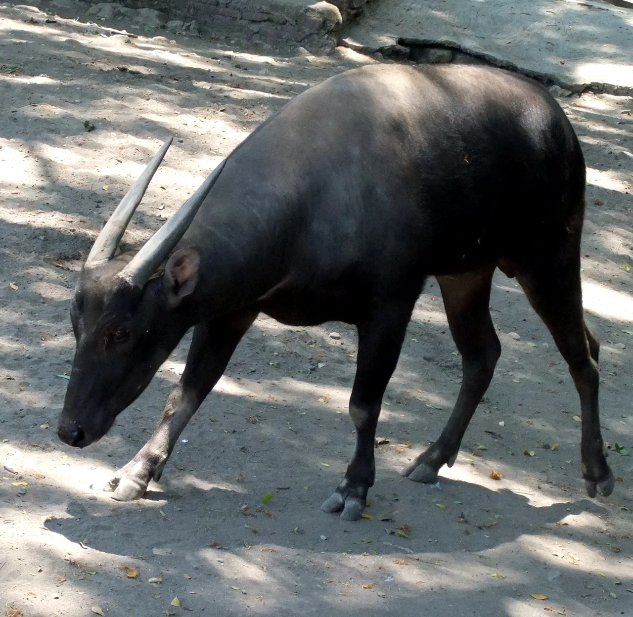
Sulawesi straddles one of the most important biogeographical boundaries on Earth. The Wallace Line, named for the naturalist Alfred Russel Wallace, marks the transition between Asian and Australian fauna, and Sulawesi sits squarely in the mixing zone. The result is an island of evolutionary oddities: creatures that evolved in isolation after the landmass rifted away from its neighbors millions of years ago. Gandang Dewata National Park protects a remarkable concentration of these endemic species. Research by the Indonesian Institute of Sciences (LIPI) in 2013 documented the park as habitat for numerous endemic bird species and identified several species entirely new to science. A broader 2016 survey recorded 417 bird species within the park, 116 of them endemic to Sulawesi. The anoa, a dwarf buffalo found nowhere else, browses the understory. The babirusa, a tusked pig whose name translates to pig-deer, roots through the forest floor. Tarsiers cling to branches with oversized eyes adapted to the perpetual twilight beneath the canopy.
Three Thousand Meters of Cloud Forest
Tanete Gandangdewata is the highest peak in the Quarles Range, the mountain spine that runs through western Sulawesi. The main summit reaches 3,074 meters; a northern sub-peak stands at 3,037 meters, and the southern at 2,966. Northeast of the main summit, Puncak Mistis -- the Mystical Peak -- rises to 3,037 meters, a name earned by the clouds that envelop it for most of the year. Two multi-day routes lead to the top, both demanding. The terrain climbs through lowland rainforest, transitions to moss-draped montane forest, and finally breaks into the stunted vegetation of the alpine zone, where the drum-shaped summit stone sits amid wind-scoured rock. In 2017, five climbers from Bandung had to be evacuated from the mountain after succumbing to exhaustion and hypothermia -- a reminder that despite its proximity to the equator, Gandang Dewata's altitude creates conditions that can turn lethal.
Waterfalls and Hidden Peaks
The park's lower elevations are laced with waterfalls that cascade down from the Quarles Range's steep western slopes. Bata, Buttuada, and Samababo are the most accessible, each tumbling through gaps in the forest where sunlight reaches the water for a few hours each day. Hernon Hill and Mambuliling Peak offer vantage points across the park's interior, and Talepom Bulam Peak opens views eastward toward the central Sulawesi highlands. Infrastructure remains minimal. There are no paved roads into the park's core, no visitor centers, no marked trails in the Western sense. Access runs through the Mamasa Regency, a district where a significant number of villages still lack electricity and the economy rests on subsistence farming, cocoa, and palm oil. The park's remoteness is both its vulnerability and its protection: what keeps tourists away also keeps loggers and poachers at a distance.
Uranium Beneath the Roots
Beneath the forest that conservationists are working to protect lies a different kind of resource. The mountains of West Sulawesi contain deposits of nickel, thorium, and uranium, and radiation surveys have detected levels significant enough to warrant further investigation. The tension is familiar across Indonesia: a young national park, barely a decade old, sitting atop mineral wealth in a province where above-average economic growth has not yet translated into broad prosperity. The Mamasa people, whose language gave the mountain its name, practice subsistence agriculture on the surrounding slopes. Cocoa and palm oil plantations press against the park's boundaries. For now, the designation holds. The 2016 declaration by the Indonesian Ministry of Environment and Forestry recognized what LIPI's scientists had argued: that Gandang Dewata's biodiversity, much of it still uncatalogued, is irreplaceable.
The Echo Persists
Gandang Dewata remains one of Indonesia's least-visited national parks, overshadowed by Komodo and Bromo-Tengger-Semeru and the other parks that appear on tourist itineraries. No international flights land in Mamasa. The journey from Makassar requires hours of driving on mountain roads that dissolve in the rainy season. But the obscurity means something survives here that has vanished from more accessible places: pristine Wallacean forest, undisturbed by the pressures that have fragmented habitat across the rest of Sulawesi. Researchers continue to find species previously unknown to science. In 2024, a team confirmed the presence of Paucidentomys vermidax, a rare endemic shrew-rat so infrequently observed that its very existence was uncertain. The mountain keeps its secrets grudgingly, revealing them only to those willing to make the climb. And somewhere on the summit, when conditions align, the Mamasa say you can still hear it -- the echo of a drum that no human hand has struck.
From the Air
Gandang Dewata National Park is centered at approximately 2.95S, 119.45E in the Quarles Range of western Sulawesi. The peak of Tanete Gandangdewata (3,074m / 10,085 ft) is the highest point in the range and is visible from cruising altitude as a prominent summit in the mountain spine. The nearest airport is Tampa Padang Airport (WAFJ) in Mamuju, roughly 100 km to the northwest. Sultan Hasanuddin International Airport (WAAA) in Makassar lies approximately 250 km to the south. The park's dense cloud forest canopy and frequent cloud cover may limit visibility at lower altitudes.
Nearby Stories
- Land of the Heavenly Kings: Tana Toraja 17 km away
- The Five Minutes That Swallowed the Teratai Prima 32 km away
- The Shortcut That Wasn't 36 km away
- Tana Toraja: The Land Where the Dead Never Leave 44 km away
- Sulawesi's Cloud Forests: Evolution's Island Laboratory 89 km away
- Two Minutes of Distraction 115 km away
- The Entertainers of Bada Valley 130 km away
- The Invisible Wall of Makassar Strait 214 km away