Gizo, Solomon Islands
One of the two men who pulled Lieutenant John F. Kennedy out of the water lived on Gizo. His name was Eroni Kumana. When Robert Ballard - the same oceanographer who found the Titanic - arrived on Ghizo Island to make a National Geographic special about the wreck of PT-109, Gizo was where he staged from, and the islands where the shipwrecked American sailors had taken shelter in 1943 lay just to the southeast. Plum Pudding, Olasana, Naru. The kind of names that should belong to a children's story, and in a way do. Seven thousand people live on Ghizo today. They have survived more than most towns their size.
An Island That Became State Property
Gizo sits on Ghizo Island, roughly 380 kilometers west-northwest of Honiara, tucked into the Western Province of the Solomon Islands with a small landing strip on the neighboring islet of Nusatupe. What makes Gizo administratively unusual is a consequence of a dark local history. The area has a documented history of headhunting, and according to local stories the Gizo tribe were notorious practitioners. The surrounding tribes took a drastic step: they united to wipe the Gizo out. The stories say only a Gizo woman and her son survived. That erasure of customary owners meant Ghizo Island was later declared state property, rather than held under the customary land tenure that governs most of the Solomons. The accident of registered title made Ghizo unusually easy for foreigners to buy into - which is how it became an administrative and business center for the province. A headhunting campaign four or five generations back is still shaping how people here buy a house today.
The Mission and the Mahaffy Station
Colonial administration arrived in January 1900, when Arthur Mahaffy - Deputy Commissioner to Resident Commissioner Charles Morris Woodford - set up a government station at Gizo with orders to suppress headhunting in New Georgia and the neighboring islands. Two years later, in 1902, Reverend John Francis Goldie established the Methodist Mission in Western Province. Goldie was a force. He built loyalty among Solomon Islander members of his church and he built friction with the British Solomon Island Protectorate administrators, who never quite reconciled themselves to Goldie's effective control of the western Solomons. Sixty-two years later, in 1964, Bishop EJ Crawford blessed St. Peter's Cathedral on Gizo - the town's Catholic cathedral, built into the same small hillside community where Methodist and Anglican and colonial and customary authority had all jostled for a century. The churches stand a few minutes apart, quiet in the heat, their congregations still central to the town's week.
War Came and Went
Imperial Japanese troops occupied the islands in 1942 and held them into the autumn of 1943. The fighting that ended that occupation happened mostly offshore, in the sea passages between Ghizo and Arundel and Kolombangara - night battles, barge evacuations, bombing raids. The Japanese evacuated Gizo on 20-21 September 1943 as part of the withdrawal from Arundel. When the war moved on, the islands were left to their recovery - overgrown airstrips, rusting equipment, a few scars in the reef. One American story survived above the rest. In August 1943, the Japanese destroyer Amagiri rammed and cut in half a small American patrol torpedo boat, PT-109, in the Blackett Strait not far from here. The survivors - including the future president - swam to Plum Pudding Island (now called Kennedy Island) and later to Olasana. Two Solomon Islander scouts, Biuku Gasa and Eroni Kumana, found them. Kennedy carved a message into a coconut shell; they carried it across the water to an Australian coastwatcher; the crew was rescued. The coconut sat on Kennedy's desk in the Oval Office for the rest of his life. Eroni Kumana lived out his days on a nearby island, and his son still lives there.
The Morning of the Tsunami
On 2 April 2007, the sea withdrew. It always does, in the minutes before a tsunami. An 8.1 magnitude earthquake had occurred only 25 miles from the town, and because the event happened in daylight and because the tide's retreat gave warning, many people understood what was about to come. They ran for high ground. The final official death toll across the Western Province and Choiseul was 52. On Choiseul, the village of Sasamunga northeast of Gizo took ten-meter waves that demolished houses, food gardens, and the hospital. Fifty-two is a small number compared to some of the century's disasters, and it is only that small because people here had the minutes they needed. The town of Gizo was damaged, buildings pushed off foundations, the waterfront reshaped. Aid arrived. Rebuilding began. Three years later, in January 2010, two more earthquakes - 7.2 and 6.5 - shook the area within an hour. In March 2011, the town was under tsunami warning again, this time from the catastrophe off Tohoku. The Pacific Ring of Fire is not an abstraction here.
Gizo Now
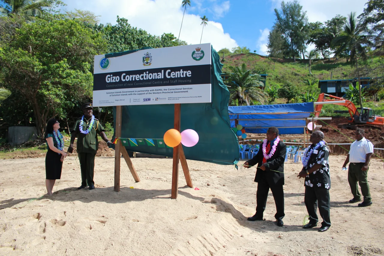
Tourism is the quiet economic engine these days - the reefs around Gizo are among the finest diving in the South Pacific, and a generation of backpackers and serious divers have found their way here on the little flight from Honiara to Nusatupe. You can take a boat out to Kennedy Island in half an hour, snorkel over coral walls, and watch parrotfish nose through the staghorn. The town itself is small enough to walk across in twenty minutes - market, wharf, cathedral, the government offices. Construction began on a new correctional center in December 2010. Children swim off the reef at dawn. The rain comes as it always does - a tropical rainforest climate, heavy throughout the year - and the sea and the sky trade places several times a day. Seven thousand people live here who have inherited a history most capital towns their size never carry. They have made, out of all of it, a place.
From the Air
Gizo is located at 8.1°S, 156.85°E on Ghizo Island in Western Province, Solomon Islands. The airstrip is at Nusatupe (AGGN), a small coral islet to the northeast of Ghizo. Recommended viewing altitude: FL100-FL180 gives excellent perspective on the surrounding channels - Vella Gulf to the northwest, the Blackett Strait where PT-109 was lost to the east, and Kolombangara's volcanic cone rising above the haze. Nearby Plum Pudding (Kennedy) Island, Olasana, and Naru lie just southeast of Ghizo. Tropical weather with heavy afternoon convection; mornings typically offer the clearest visibility across the island group.
Nearby Stories
- 2007 Solomon Islands Earthquake 4.9 km away
- Japanese destroyer Arashi 11 km away
- Battle of Vella Lavella (naval) 51 km away
- Battle of the Treasury Islands 131 km away
- Woodlark Island 411 km away
- Païta 1794 km away
- Maré Island 1858 km away
- 1737 Kamchatka Earthquake 6720 km away