
Hegra
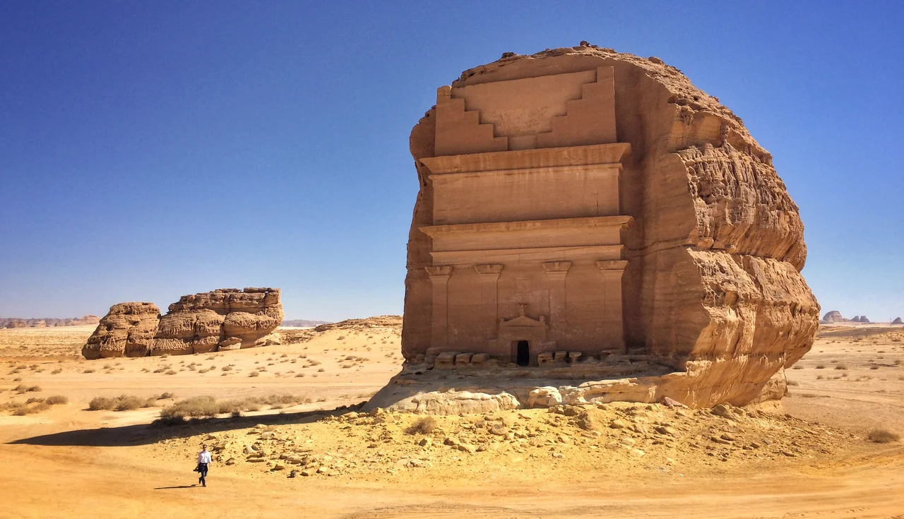
Stand before Qasr al-Farid and the first thing you notice is how alone it is. Most Nabataean tombs huddle together, chiselled into continuous cliffs. This one rises from a single sandstone outcrop in the open desert, seventeen meters of carved facade with no neighbors at all. Its name means "the Lonely Castle," and the masons never finished it. Look closely near the base and you can watch the craftsmanship dissolve, the crisp pilasters giving way to rough rock, as if the carvers simply set down their tools two thousand years ago and walked away. They worked top to bottom, these people, cutting their monuments downward into the stone. Whatever made them stop, the tomb has waited here ever since, the unofficial emblem of a city most of the world has never heard of.
The Second Capital
Hegra was the Nabataeans' great southern city, the second capital of a desert kingdom that grew rich controlling the incense roads. Frankincense and myrrh moved north from Arabia toward the Mediterranean, and whoever held the wells and waystations held the trade. The Nabataeans held them brilliantly. Their better-known capital, Petra, sits in what is now Jordan; Hegra was its counterpart roughly five hundred kilometers south. Here they applied the same genius: tombs cut directly into the rock, their facades blending Greek columns, Egyptian cornices, and Mesopotamian step-patterns into something wholly their own. The monuments date from the first century BC to the first century AD, the height of Nabataean confidence, before Rome absorbed the kingdom in 106 AD.
A City of the Dead
What survives at Hegra is mostly funerary. The site holds 111 monumental tombs, 94 of them decorated with carved facades, scattered across several rocky outcrops that the Nabataeans treated as necropolises. Many bear inscriptions naming the families who commissioned them, along with stern warnings against anyone who might dare reuse the grave. These were status symbols as much as resting places, advertisements in stone for merchant dynasties grown wealthy on caravans. The Nabataeans were also extraordinary engineers of water, cutting wells and channels to coax life from a landscape that receives almost no rain. A city could not survive out here on trade alone. It needed to drink.
The Forbidden Place
For centuries Hegra carried a darker reputation. In Islamic tradition the area is identified with the people of Thamud, who the Qur'an describes as having been destroyed for their defiance, and the prophet Saleh was said to have been sent to warn them. The site's other name, Mada'in Salih, means "Cities of Saleh." Travelers long avoided the place, regarding it as cursed ground best passed quickly. That reputation, combined with Saudi Arabia's long closure to tourism, kept Hegra one of the least-visited great archaeological sites on Earth, magnificent and almost entirely empty while crowds thronged Petra to the north.
Opening the Gates
Things changed quickly. In 2008 Hegra became Saudi Arabia's first UNESCO World Heritage Site. In 2019 the kingdom began issuing tourist visas, and the surrounding Al-Ula region was reimagined as a flagship cultural destination. Today visitors reach the tombs by guided tour, bussed in from a visitor center near Al-Ula, twenty-two kilometers away. There are vintage Land Rover excursions and night tours under desert stars, luxury resorts, and, on the site itself, a single gelato cart. It is a strange and rapid transformation: a place once shunned as forbidden now polished and presented to the world, its silence carefully managed but still, in the spaces between tour groups, genuinely vast.
From the Air
Hegra sits at 26.81°N, 37.95°E in the Hejaz highlands of northwest Saudi Arabia, at roughly 600 meters elevation. The nearest airport is Al-Ula International (ICAO: OEAO / IATA: ULH), about 25 km southwest and a short drive from the tombs. Tabuk's Prince Sultan bin Abdulaziz Airport (ICAO: OETB) lies farther north. From the air the landscape reads as pale sandstone outcrops and weathered domes rising from desert flats; the isolated block of Qasr al-Farid and the nearby Elephant Rock are the clearest landmarks. Best viewed in the cool, clear winter months (November to March); summer brings haze and temperatures above 40°C. Recommended viewing altitude 3,000-6,000 feet AGL for the rock formations.
Nearby Stories
- Al Naslaa 31 km away
- Tayma 94 km away
- Mustatil 130 km away
- Battle of Khaybar 177 km away
- Neom 229 km away
- Tiran Island 295 km away
- Rock Art of Hail Province 323 km away
- Wadi El Gemal National Park 330 km away