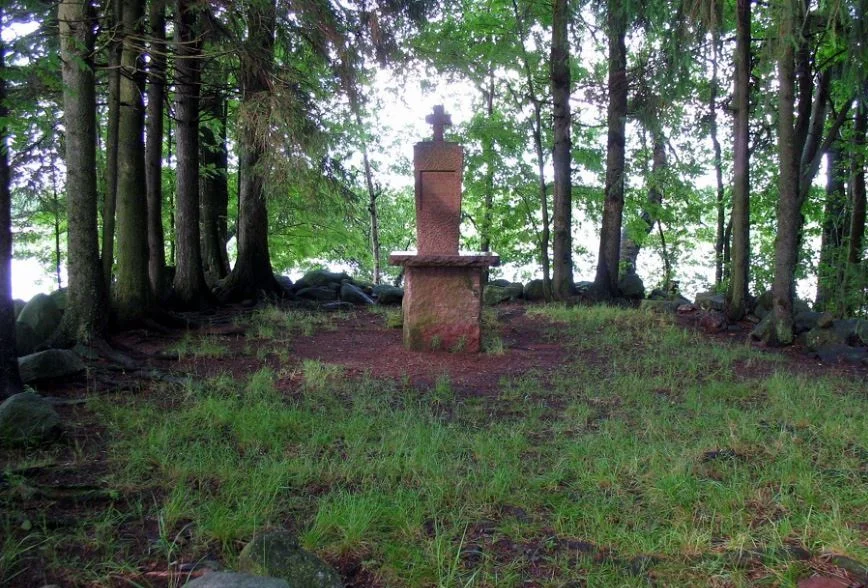

Kirkkokari
On the Sunday before Midsummer, boats cross two hundred metres of open water to a rock barely large enough to hold a congregation. Kirkkokari runs to about a third of a hectare, and its highest point stands roughly one metre above the surface of Lake Köyliö. There is an altar, a memorial, and a rectangle of foundation stones in the grass. That is the whole inventory — and this is the only Roman Catholic pilgrimage site in modern Finland, and one of very few anywhere in the Nordic countries.
The Church Islet
The name means Church Islet, and older maps also label it Pyhän Henrikin saari, Saint Henry's Island. Both point at the same thing. A chapel is said to have been raised here in the fourteenth century to mark the spot where, by tradition, Bishop Henry was killed on the lake ice in 1156. Its footprint has been rebuilt in stone and measures something like seven metres by eleven, which means the building once covered close to half the island. Excavators found a layer of logs beneath it. The chapel remained in use into the eighteenth century before it fell to ruin, leaving stones and rotted timber behind. Seen from the mainland shore, two hundred metres off, the whole place reads as a stony bump in a reed bed.
What the Diggers Found in 1904
Hjalmar Appelgren excavated the islet in 1904 and 1905, and the finds make the case for pilgrimage better than any document could. Sixty-six silver coins and seventy-eight copper ones came out of the ground, spanning the reign of King Albert of Mecklenburg in the late fourteenth century through to Adolf Frederick in the 1700s — four centuries of small offerings dropped, left, or pressed into the soil. There were pilgrim badges, possibly carried here from Trondheim. There was a gilded silver ring bearing an image of Christ. Fragments of window glass and strips of lead showed that this tiny chapel, marooned in a Satakunta lake, had stained glass. Amber and jet beads completed the picture of a place people travelled to and paid for the privilege of reaching.
A Cult That Arrived Late
The devotion is genuine. The chronology deserves honesty. Henry's veneration surfaced suddenly in the mid-1290s with strong backing from the church, at a moment when Sweden was going to war against Novgorod. He was being called a saint by 1296, though never formally canonised, and no record survives of his birth or his death. Folk veneration on Kirkkokari began later still, well after his official standing as a local saint and roughly two centuries after the killing it commemorates. The pilgrims who came here were not tracing a living memory. They were joining something that had been assembled for them — and their coins in the soil say they believed in it completely, which is its own kind of fact.
Modern Stones
Two monuments stand on the islet now, both of them twentieth-century. In 1955 a memorial to the Christianisation of Finland was raised here; in 1999 a small altar followed, Saint Henry's altar, giving present-day pilgrims a focus for the open-air Mass. Getting out has not changed much. You row, or you take the boat that runs from the Lähteenkylä shore. Kaukosaari lies only a hundred metres away across the channel and the water is shallow — Köyliönjärvi averages under three metres deep — but the crossing still has to be made deliberately, by arrangement, in a small vessel. That is arguably the whole idea.
Walking the Hundred and Forty
Most people arrive here at the end of a long walk. The Catholic Church in Finland organises an annual pilgrimage along Saint Henry's Way, a 140-kilometre route beginning at Turku Cathedral: north through Nousiainen, where Henry's bones were said to rest before being moved to Turku around 1300, then on toward Köyliö and eventually Kokemäki. The final act happens out on the water, on the last Sunday before Midsummer, in a country where the midsummer light barely fails at all. A congregation of walkers stands on a third of a hectare of rock, one metre above the lake, at the end of a story nobody has ever been able to verify.
From the Air
Kirkkokari sits at 61.1474°N, 22.3253°E, in the northern reach of Köyliönjärvi in Satakunta, at a lake elevation of 40.5 metres. It is tiny — roughly a third of a hectare, its high point about a metre above the water — so from altitude look for the lake first: a ten-kilometre ribbon under two kilometres wide, with Kirkkosaari's three-kilometre bulk to the south and Kaukosaari only a hundred metres from Kirkkokari itself. The islet lies about two hundred metres off the mainland shore. Eura Airfield (EFEU) is just south, Piikajärvi (EFPI) northwest near Kokemäki, and Pori (EFPO) and Tampere-Pirkkala (EFTP) are the nearest served airports. A pass at 1,500 to 2,500 feet AGL is low enough to pick the islet out of the reed beds. Best light is a long summer evening; in winter the frozen lake flattens the island into the ice and it becomes very hard to see.
Nearby Stories
- Sammallahdenmäki: Graves Built for a Shoreline That Left 3.9 km away
- St. Olaf's Church, Tyrvää 4.8 km away
- Kurjenrahka National Park 12 km away
- Hotel Otava 16 km away
- Nakkila Church 17 km away
- Uusikaupunki Automobile Museum 19 km away
- Church of Loimaa Proper 24 km away
- Jokioinen 35 km away