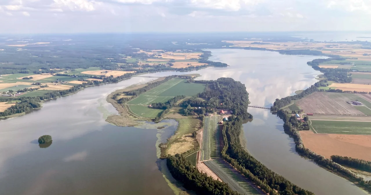

Köyliönjärvi
Köyliönjärvi freezes hard. By January the ice becomes a road: ten kilometres of it, running the length of a lake barely two kilometres wide, farmhouses on both shores and the low silhouettes of five wooded islands breaking the white. For centuries this was the fastest way to travel here, which is why the story that made the lake famous happens on the ice rather than beside it. Finnish schoolbooks long described the killing of Bishop Henry by a farmer named Lalli, on this surface in January 1156, as the first documented historical event in the country. It is a strange claim, because almost nothing about it is documented.
The Story on the Ice
The version most Finns know comes from a folk poem, "Henrikin surma" — the slaying of Henry. In it, a bishop travelling by sleigh takes hospitality at Lalli's farm while Lalli is away, and Lalli's wife Kerttu tells him afterwards that the visitor plundered them. Lalli catches the sleigh out on the lake and kills the bishop with an axe. The poem is vivid, circumstantial, and roughly thirteenth-century — which is to say it was composed something like a hundred years after the event it describes, and no earlier than the Latin church legend it competes with. As history it offers almost nothing that can be checked. As literature it has outlasted very nearly everything else in medieval Finnish verse.
Two Men, Neither Quite Solid
Henry is called the first bishop of Finland, and there is no record of his birth, his death, or his existence. An account of his life was written down in the 1270s or so, some 150 years after the fact, to build the case for his sainthood; he was being called a saint by 1296 but was never formally canonised, and his cult appeared abruptly in the mid-1290s with the church firmly behind it. Lalli is thinner still, since the church legends never name him at all. What he became, though, is very solid indeed. Medieval Finnish churches carved him lying beneath Henry's feet, the trampled heathen. Nineteenth-century nationalists inverted him into a farmer defending his own ground against foreign bishops and Swedish rule. In a 2004 television vote for the greatest Finns, Lalli finished fourteenth.
Older Than the Legend
Whatever happened or failed to happen in 1156, people had been living around this lake for a very long time beforehand. The shores and islands hold late Iron Age cemeteries — the burial ground at Vanhakartano was in use between roughly 975 and 1150, and two more sit on the north side of Kirkkosaari. Kirkkosaari is the big island, three kilometres of it, and it has carried a church since the fifteenth century; the building standing there now dates from 1752. Continuous habitation since the Iron Age is the phrase archaeologists use for this landscape, and it is unusual enough in Finland to be worth pausing on. The legend is a late arrival somewhere that was already old.
A Metre of Water, Gone
The lake Lalli supposedly crossed was larger and deeper than the one on the map today. In 1813 Baron Cedercreutz proposed lowering it to win farmland; dredging followed in 1821 and 1822, a mechanised second campaign between 1938 and 1940 dropped the surface a further 65 to 90 centimetres, and a final clearing in 1982 was fitted with a dam to hold the additional drop to eight. Add it up and the water once stood more than a metre higher than it does now. The gain was farmland, and the farmland has since become the problem. Phosphorus has roughly tripled since the 1960s, and Köyliönjärvi is officially in poor condition, choked by runoff from the fields that draining it created.
A National Landscape
None of that has cost the lake its standing. Köyliönjärvi and its surroundings sit on Finland's short official list of national landscapes, places held to embody something essential about the country, and the case is easy to see from any shore road: water, reed beds, weathered farm buildings, a church tower, fields running down to the edge. Köyliö itself no longer exists as a municipality — it merged into Säkylä on the first day of 2016 — but the lake kept the name. The old story keeps finding new containers too, among them "Köyliönjärven jäällä," a song by the Finnish metal band Moonsorrow about a killing on the ice that may never have happened at all.
From the Air
Köyliönjärvi lies at 61.1372°N, 22.3267°E in Satakunta, at a surface elevation of 40.5 metres. From the air it is unmistakable: a narrow ribbon of water about 10.3 kilometres long and under two kilometres wide, with 36.8 kilometres of shoreline and five islands totalling 146 hectares — Kirkkosaari the largest at three kilometres, then Kaukosaari, Heinisaari, Kirkkokari and Härkikari. Its outflow, the Köyliönjoki, runs to the Eurajoki system. Eura Airfield (EFEU) sits just south, Piikajärvi (EFPI) lies northwest near Kokemäki, and Pori (EFPO) and Tampere-Pirkkala (EFTP) are the nearest airports with services. Fly it at 2,000 to 3,500 feet AGL to hold the whole lake in frame. In winter it freezes solid and reads as a bright white slot in dark forest and field; midsummer offers nearly round-the-clock light but frequent haze off the surrounding farmland.
Nearby Stories
- Sammallahdenmäki: Graves Built for a Shoreline That Left 3.9 km away
- St. Olaf's Church, Tyrvää 4.8 km away
- Kurjenrahka National Park 12 km away
- Hotel Otava 16 km away
- Nakkila Church 17 km away
- Uusikaupunki Automobile Museum 19 km away
- Church of Loimaa Proper 24 km away
- Jokioinen 35 km away