Kuraman Island: The Tiger's Lair of Borneo
An Italian novelist who never left Europe gave this island its most famous name. Emilio Salgari, writing from a desk in Turin in 1900, called it Mompracem and made it the lair of Sandokan, his fictional Malay pirate prince who battled the British Empire across a series of wildly popular adventure novels. Salgari had never seen Borneo, never felt the humidity of Brunei Bay, never watched green turtles drag themselves onto the beaches he described with such confident invention. But he chose well. Kuraman Island -- the real Mompracem -- sits at the northern mouth of Brunei Bay, a 1.47-square-kilometer knot of jungle, coral, and shipwrecks that has accumulated enough actual drama to rival anything Salgari imagined.
From Sultanate to Crown Colony
Long before Salgari gave it a fictional pirate king, Kuraman belonged to a real one -- or near enough. The island fell under the thalassocracy of the Sultanate of Brunei, a maritime empire that controlled much of northern Borneo's coast and the trade routes that threaded through its islands. That dominion ended on 18 December 1846, when the Treaty of Labuan ceded Kuraman, along with Labuan and its surrounding islands, to the British. The new rulers built a lighthouse on the island's highest point between 1897 and 1913, a structure that still stands, its stone walls weathered but intact. When the Japanese swept through British North Borneo during the Second World War, Kuraman was captured along with the rest -- though no fighting ever occurred on the island itself. Liberation came in 1945, courtesy of the Australian Army's 2nd AIF. By 1946 the Crown Colony of Labuan had been folded into North Borneo, and when Malaysia formed in 1963, Kuraman followed Labuan under the administration of the Sabah government.
A Graveyard of Ships
The waters around Kuraman are littered with the remains of vessels that never completed their voyages. A Dutch steamer and a minesweeper sank here during the Second World War, their hulls settling into the silt of Brunei Bay. Decades later, the MV Tung Hwuang, a freighter hauling cement to Brunei for the Sultan's new palace -- the colossal Istana Nurul Iman -- went down in the 1980s, its cargo hardening around the wreck in an inadvertent sarcophagus. The MV Mabini Padre, a Philippine trawler, caught fire and sank in 1981, adding another skeleton to the collection. These wrecks have made Kuraman one of the premier dive destinations in the Labuan Marine Park, which the island shares with Great Rusukan and Little Rusukan islands. Divers descend into murky, current-swept water to explore rusting superstructures colonized by soft corals and schooling fish -- a kind of underwater archaeology that requires nerve as much as curiosity.
Refugees, Turtles, and a Vanishing Shoreline
Before it was gazetted as a marine park, Kuraman had human residents of a different sort. Around 80 refugee families, registered under the United Nations High Commissioner for Refugees, lived on the island in two settlements: Kampung Warisan and Kampung Singgahmata. Their presence was quiet, their villages modest. When the marine park designation came, the island's purpose shifted from shelter to conservation. Today, green turtles nest on its sandy beaches, and the Megapodius lowi -- a scrubfowl found chiefly on Kuraman -- forages in the island's interior, though its nests are more commonly discovered on the Labuan mainland. Sea birds and butterflies populate the canopy. But the island is losing ground. Large storms in recent years have accelerated erosion, washing vegetation and buildings into the sea. The jungle paths that once wound through the interior grow shorter with each monsoon season, and the beaches where turtles lay their eggs narrow year by year.
No Roads, No Vehicles, One Lighthouse
Kuraman remains a place defined by what it lacks. There are no roads, no vehicles, no permanent commercial infrastructure. Access comes by boat -- a small private jetty and a newer government pier serve as the island's only connection to the outside world. The interior is forested with a range of tropical hardwoods, crisscrossed by cleared paths that invite jungle walks under a dense canopy. Two main beaches face different directions, offering distinct personalities: one calm and sheltered, the other exposed to the open waters of Brunei Bay. Between the island and Kiamsan Point on Labuan lies the Sunken Rock, a navigational hazard that has menaced mariners for centuries. The British lighthouse still occupies the highest point, a colonial relic watching over waters that have swallowed ships from four different nations. The island is part of the future Labuan secondary economic development zone, which prioritizes preservation of agricultural areas, rural settlements, and heritage tourism -- a plan that would keep Kuraman much as Salgari might have recognized it, if he had ever bothered to visit.
From the Air
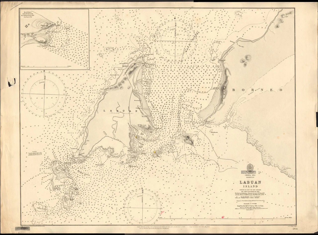
Kuraman Island is at 5.22°N, 115.13°E, visible on the northern mouth of Brunei Bay south of Labuan Island. Look for the small forested island with sandy beaches and a prominent sand spit. The British lighthouse on the island's high point may be visible in clear conditions. Labuan Airport (WBKL) is approximately 8 km to the north. Best viewed at 1,500-2,500 feet to appreciate the island's relationship to Labuan, the surrounding reefs, and the wreck diving sites in the channel waters.
Nearby Stories
- Mosquito Island's Older Residents 4.5 km away
- Where the River Meets the Sea 16 km away
- Sabah State Railway 20 km away
- De Fontaine Memorial 53 km away
- Brunei's Billion-Dollar Bet on Urea 58 km away
- Kinarut Mansion 104 km away
- Maliau Basin 137 km away
- Luconia Shoals 233 km away