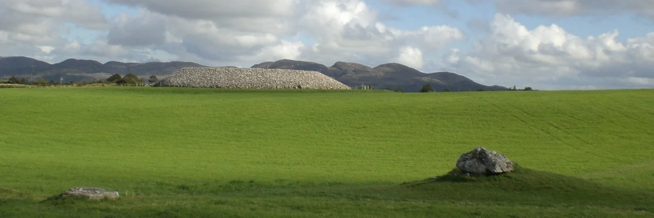

Listoghil
Carbon dating puts the bones beneath this mound at around 3500 BC - older than Newgrange, older than the pyramids at Giza, older than almost anything human hands have left standing in Western Europe. Listoghil sits at the dead centre of Carrowmore, a scatter of more than sixty stone monuments draped across a low ridge on the Cúil Irra Peninsula, three kilometres west of Sligo town. The satellite tombs face inward toward it. They circle it the way pilgrims circle a shrine, which, in a sense, is exactly what they are doing.
The Mound at the Centre
Listoghil is the only true cairn in the Carrowmore complex. Its sixty-odd neighbours are dolmen circles, open and uncovered, ring-shaped settings of standing stones that once held cremated bone. Listoghil is different. Thirty-four metres across and four metres tall after its 1990s restoration by Sweden's Goran Burenhult and the Office of Public Works, it holds a dolmen-like chamber crowned by a single tilted limestone slab. Inside, six orthostats prop up the roof, and faint concentric circles - a rare example of Irish megalithic art outside the Boyne valley - surface only in certain raking light. The bones found within were a mix of cremated and uncremated remains. The smaller satellite tombs hold only burnt bone. Whatever Listoghil meant, it meant something different from the rest.
Ryefort, or Something Older
The antiquarian George Petrie, writing in 1837, recorded the name as Lios a' tSeagail - the Fort of the Rye. Lios in Irish, though, refers more broadly to a court or enclosure, and Petrie himself wondered whether the name originally meant not the mound but the great ringed space around it, the bowl of land in which all those dolmen circles stand. He gave the cairn its working title that same year: Carrowmore 51. Archaeologists still use it. Petrie also noted another cairn at nearby Leacharail that nobody has ever managed to find. It may have stood near here. It may be one of the heaps of stones quarrymen carted away in the 1880s for road metal, breaking up the dead's houses to mend the living's roads.
The Sun on Two Days
The chamber is aligned. Not to a solstice, but to something subtler. The axis points 6.5 kilometres east-southeast, to a low saddle in the Ballygawley Mountains where the sun rises on roughly 31 October and 10 February - the modern dates that bracket the Gaelic winter, the festivals later called Samhain and Imbolc. On those two mornings, light slips down the artificial gabion-walled passage and reaches the chamber's heart. It is the same alignment, to the day, as the Mound of the Hostages at Tara, hundreds of kilometres away. Two Neolithic communities, separated by distance but apparently not by belief, watched the same sun mark the same turn of the year.
What Was Lost
By the 1880s, locals were carting Listoghil's stones away for roadbuilding. The destruction stopped only when quarrymen broke into the burial chamber and stopped, perhaps from awe, perhaps from the bones tumbling out at their feet. Victorian antiquarians sifted the wreckage and recorded "bones of horses," charred wood, a worked flint javelin head. Some of what they collected ended up in the collections of Alnwick Castle in Northumberland, far from the hill it had rested under for fifty-three centuries. Inside the chamber, on one of the stones, the writer Julian Cope once spotted what he described as a "strangely distorted tryfuss" - a triple spiral, the most ancient of Irish symbols, carved by someone whose name will never be known.
Why It Still Matters
Listoghil predates Newgrange by roughly seven centuries. It predates the Great Pyramid by nearly a millennium. Yet unlike Newgrange, no surviving legend ties Listoghil to gods or heroes - the Cúil Irra district is thick with story, but Listoghil itself has slipped out of memory. Knocknarea rises to the west, crowned with Queen Maeve's great cairn, twice Listoghil's diameter and visible for kilometres. Two great cairns stand on Cairns Hill to the east. Listoghil sits in the middle, modest by comparison, central by design. Whatever ceremonies once unfolded here - whatever the chamber's careful alignment to the cross-quarter sunrise was meant to mark - the people who built it have been silent for fifty-five hundred years. The stones still keep their council.
From the Air
Listoghil sits at the geographic centre of the Cúil Irra Peninsula at 54.249°N, 8.519°W, 59 m above sea level and roughly 3 km west of Sligo town. From the air, the cairn appears as a distinct circular feature on a low limestone ridge, with the Carrowmore satellite tombs scattered around it. Knocknarea (327 m, crowned by Queen Maeve's cairn) rises 4 km to the west; the Atlantic of Sligo Bay lies just beyond. Sligo Airport (EISG) is 4 km west on the Coolera Peninsula. Best viewed at 1,500-2,500 ft AGL in good visibility; Knocknarea's height calls for awareness of local lift and turbulence on westerly winds.
Nearby Stories
- Killala 5.5 km away
- Ballaghaderreen 7.4 km away
- Townlands of Kilcommon 10 km away
- River Shannon 11 km away
- Monastery of Mohill-Manchan 15 km away
- Pettigo 18 km away
- Killybegs 19 km away
- RMS Empress of Britain (1930) 97 km away