Ten Thousand Lightning Strikes
The lightning was not supposed to be there. Northern California's summers are reliably dry, the thunderstorm season a memory from spring. But in mid-August 2020, the remnants of Tropical Storm Fausto drifted north from the Pacific, carrying just enough moisture to generate something California firefighters dread: dry lightning. Between the early hours of August 16 and August 17, the sky over Northern California crackled with 10,849 recorded lightning strikes. Within 72 hours, those strikes had sparked 376 separate fires across the state. In the hills and canyons of Wine Country -- across Lake, Napa, Sonoma, Solano, and Yolo counties -- a cluster of those fires would merge into the LNU Lightning Complex, eventually burning 363,220 acres and destroying nearly 1,500 structures in some of Northern California's most celebrated landscape.
Fire Without Firefighters
The scale of the ignitions overwhelmed every available resource. On the morning of August 17, a spot fire was reported near Lake Hennessey on Hennessey Ridge Road. It was initially logged as the "14-3 Fire" -- a bureaucratic placeholder that gave no hint of what it would become. Nearby, the Gamble Fire was burning north of Lake Berryessa, the Spanish Fire had started near Spanish Flat, and the Markley Fire was growing near Monticello Dam. Under normal circumstances, each of these would have received immediate air and ground response. But California was burning everywhere at once. With hundreds of fires demanding attention simultaneously, these blazes were not suppressed during their most critical early hours. By evening, each had grown to between 1,000 and 8,000 acres with zero percent containment. In Sonoma County, the Walbridge Fire -- initially cataloged as the "13-4 Fire" -- had ignited in the rugged hills above Austin Creek State Recreation Area and was burning unchecked toward the communities between Healdsburg and Stewarts Point.
The Night the Hills Came Down
The most devastating hours came on the night of August 17 into August 18. The Hennessey Fire, driven by wind and dry conditions, traveled thirteen miles to the southeast, tearing through the Vaca Mountains and pouring down the canyons toward Fairfield and Vacaville. At 11:30 p.m., fire officials described its rate of spread as "critical to dangerous." Mandatory evacuations expanded in waves -- first the Berryessa Highlands and Spanish Flat, then north Fairfield and northwest Vacaville as the fire front descended Mix Canyon Road to Pleasants Valley Road. Hundreds of structures were destroyed in areas west and north of the cities. The speed was the terrifying part. Residents who had gone to bed in houses surrounded by open grass hills woke to evacuation orders and orange skies. Some had minutes. The fires did not discriminate between vineyard estates and mobile homes; both burned with the same indifferent efficiency.
A Complex by Name and Nature
The "LNU" in the fire's name refers not to any geographic feature but to the Sonoma-Lake-Napa Unit of Cal Fire, the state's firefighting agency. A "complex" fire is a bureaucratic designation for multiple fires managed under a single incident command. In this case, the Hennessey Fire eventually merged with the Gamble, Green, Markley, Spanish, and Morgan fires, scorching 192,000 acres on its own -- more than half the complex's total footprint. The fires were mapped as a single event, but on the ground they behaved as a constellation of separate disasters, each with its own terrain, wind patterns, and threatened communities. Evacuation orders multiplied as individual fires flared and subsided unpredictably. Air attack crews reported twenty to thirty new spot fires on August 17 alone, each one ignited by the lightning strikes of the previous day and discovered only when smoke columns became visible.
The Long Containment
By early September, most of the complex was under control. Firefighters had established containment lines around the smaller fires, and the weather had shifted enough to slow the spread. But the Hennessey and Walbridge fires burned on through mid-September, smoldering in remote canyons and flaring in pockets of unburned fuel. Smoke from the complex blanketed the Bay Area for weeks, turning skies orange and pushing air quality to hazardous levels as far south as San Jose. On October 2, 2020, Cal Fire reported the entire LNU Lightning Complex fully extinguished -- forty-six days after it began. The final accounting: 363,220 acres burned across five counties, 1,491 structures destroyed, 232 more damaged, and six lives lost. The LNU Complex became one of the largest fires in California's recorded history, a record that itself would not last long in a state where the fire seasons were growing longer, hotter, and more destructive with each passing year.
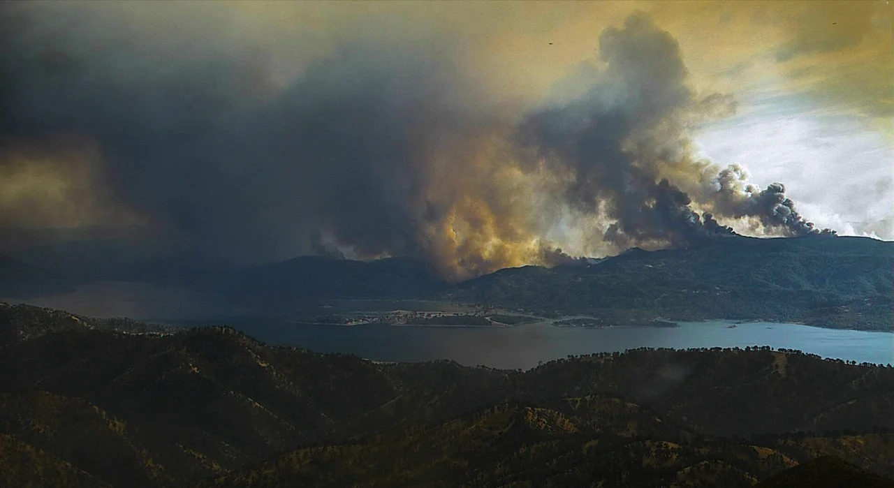
From the Air
The LNU Lightning Complex burn area spans portions of five counties in Northern California Wine Country, centered roughly at 38.50N, 122.35W near St. Helena and Lake Berryessa. From altitude, the fire scars are visible as lighter-colored patches across the hills east of the Napa Valley floor and in the Vaca Mountains between Vacaville and Lake Berryessa. Key reference points include Lake Hennessey, Lake Berryessa, and the Monticello Dam. Nearest airports: Napa County Airport (KAPC) approximately 10 nm south, Nut Tree Airport (KVCB) in Vacaville 15 nm southeast, and Charles M. Schulz-Sonoma County Airport (KSTS) 20 nm west.
Nearby Stories
- Sonoma Coast State Park 5 km away
- Engine Number 5 and the Tunnel That Kept Its Secret 5 km away
- The Canyon That Burned on Independence Day 6.5 km away
- Museum of the American Indian 8 km away
- California's Holland 16 km away
- Griffith Mansion 17 km away
- Where the Sheep Rancher Planted Stars 29 km away
- Cordell Bank: The Invisible Island 29 km away