
Lusatian Lake District
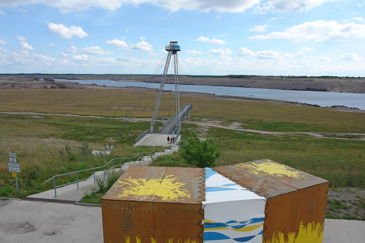
From the platform of the Rostiger Nagel you can see both halves of the argument at once. The tower is a spike of rusting steel standing where a coal pit used to be, 28.86 metres of weathering plate reached by 162 steps, and the water lapping below it is the pit. Turn north and there is the Großräschener See, another one. Turn north-east and the chimneys of the Jänschwalde power station are still smoking; east and south-east, Schwarze Pumpe and Boxberg. West, the wind farm at Klettwitz. Standing on one spot in Brandenburg you can watch the thing that destroyed this landscape, the thing that is meant to replace it, and the flooded hole in between. Around forty lakes are being made this way across Brandenburg and Saxony. None of them existed a lifetime ago, and none of them are finished.
God Created Lusatia
An old Sorbian saying has it that God created Lusatia and the Devil put the coal underneath. Under the flat sandy country between the Spree and the Neisse lies one of Europe's richest deposits of lignite, or brown coal, and it has been both the making and the ruin of the region. Lignite burns badly and smells worse, and for most of the nineteenth century it was dismissed as poor people's fuel. The First World War changed that: with black coal going to the victors as reparations, and with German chemists working out how to crack almost any carbon feedstock into industrial products, the pits went into overdrive. East Germany then had no other domestic fossil fuel at all. Homes were heated with it, power stations burned it to run the trains, and a vast chemical industry sat on top of it. The cost was villages scraped away, a water table pulled down beneath whole districts, and air that would make present-day Beijing look restorative.
Otto Rindt's Chain
The idea of doing something better with the holes belongs largely to one man. Otto Rindt, born in 1906 in Apenrade in North Schleswig, was a landscape architect who had joined the Nazi Party in 1937 and worked on the Reichsautobahn; from 1958 until the 1990s he spent his career designing what should happen to Lusatia after the diggers left. His insight was that simply letting groundwater seep back would produce a chaos of sour, disconnected ponds. Instead the pits should be filled deliberately from surface rivers and linked into a navigable chain. The proof came at the Niemtsch pit outside Senftenberg, flooded from 15 November 1967 until November 1972; the resulting Senftenberger See covers 1,300 hectares and opened its first beach in 1973. Rindt died in January 1994, having lived long enough to know that the plan had survived the country that commissioned it.
Locks Where the Diggers Were
Nine lakes are being stitched together into the Lausitzer Seenkette by canals and locks - the Barbara-Kanal opened in December 2003, the Rosendorfer Kanal in January 2006, the Sornoer Kanal running past the foot of the rusty tower. The channels are small, and so are the boats permitted on them: 28.5 metres long, 5.2 wide, 3.3 high, drawing no more than a metre and a half. By mid-2026 five of the lakes had been joined into a single sheet of some 5,100 hectares, the largest connected artificial lake system in Europe. Two passenger boats work the water. At the Geierswalder See marina there are houses that float. It is a strange kind of tourism to build from scratch, and the region is betting a great deal on it.
The Rusty Nail
The tower at the mouth of the Sornoer Kanal came out of an architectural competition held in April 2005 and won by the Munich architects Stefan Giers and Susanne Gabriel. It went up between August and October 2008, a construction period of seventy days, and was inaugurated on 23 October that year. It weighs 111 tonnes and is built entirely of Corten steel, which rusts on purpose: the oxide layer seals the metal and does the job paint would otherwise do. The colour is the point. Everything around it - the exposed spoil, the iron-stained water, the abandoned machinery - is the same shade of orange-brown, and the tower simply agrees to match. Around 146,000 people climb it in a normal year, which is a remarkable number for a viewing platform over a hole in the ground.
Ground That Moves
Mining did not stop when the lakes started. The profitable end of the business was sold off after 1990, ending with Swedish state-owned Vattenfall, which eventually decided it could not preach a green transition at home while digging the dirtiest fuel there is abroad, and sold to a Czech buyer trading as LEAG. In 2019 the German government set 2038 as the outside date for the end of lignite, with billions promised to soften the landing. Meanwhile the state company LMBV is left with the wreckage, and the wreckage is not stable: millions of tonnes of loose overburden can start moving without warning, and the closure signs on the shorelines are not decoration. The Sorbs, whose villages the pits took, still put their language on the road signs here. The water is still rising.
From the Air
The lake district is centred on roughly 51.50 N, 14.19 E, spread across the flat southern Brandenburg and northern Saxon plain between Senftenberg, Hoyerswerda and Großräschen, generally 95 to 130 metres above sea level. Best read between 2,000 and 5,000 feet AGL, and better still on a calm day when the water goes mirror-flat. From the air the region is unmistakable: geometrically edged lakes with raw pale shorelines and no floodplain vegetation, separated by long straight spoil ridges and threaded with dead-straight canals - nothing like the ragged glacial lakes further north. The Senftenberger See is the largest and most mature body of water; the Rostiger Nagel is a thin dark spike where the Sornoer Kanal meets the Sedlitzer See. Working pits still show as black terraced voids, and the cooling plumes of Schwarze Pumpe, Boxberg and Jänschwalde are visible for tens of miles in stable air. Klix (EDCI, 900 m grass, gliders) lies about 20 nm south-east and is busy with winch and tow operations in thermal season - keep clear. Dresden (EDDC) is roughly 27 nm south-west and Berlin Brandenburg (EDDB) about 58 nm north-north-west. Summer haze and coal-plant plumes can cut slant visibility sharply on stagnant days.
Nearby Stories
- Karl May Museum 6.1 km away
- Cottbus 11 km away
- Stalag VIII-A 18 km away
- Battle of Hochkirch 23 km away
- Moritzburg Castle 28 km away
- Upper Market Square (Görlitz) 33 km away
- Kummersdorf 52 km away
- Sonnenburg concentration camp 98 km away