Morro do Chapéu State Park
A park decree in Brazil does not necessarily produce a park. Morro do Chapéu State Park was created by decree on December 12, 1973, and then essentially nothing happened for twenty-five years. It was recreated by a second decree on August 17, 1998, and then almost nothing happened for another decade. In April 2011 the state government signed a third decree abolishing the park entirely. Thirty days later a fourth decree reversed the abolition. Through all of that, the caatinga kept blooming on rocky outcrops, 543 springs kept feeding tributaries of the São Francisco River, and the prehistoric rock paintings in the Brejões, Boa Esperança, Igrejinha, and Cristal caves kept waiting - as they have for thousands of years - for Brazil to decide what to do with them.
The Land the Park Was Meant to Protect
The municipality of Morro do Chapéu sits in the northern reaches of the Chapada Diamantina, a highland plateau where scenic beauty is almost an understatement. The park covers 46,000 hectares at the meeting point of two of Brazil's great biomes - the cerrado savanna to the south and west, the thorny caatinga scrubland to the north and east - and that ecotone, where the two worlds touch, is what makes the place biologically extraordinary. Orchids and bromeliads grow in rock gardens that would look at home in a botanic collection. Cacti rise between them. Areas of dune hold herbaceous vegetation that bends in the wind. The sub-basins of the Salitre, Jacaré, Utinga, and Jacuípe rivers all rise here, feeding ultimately into the Paraguaçu and the São Francisco - the great river systems that water northeastern Brazil. The 543 catalogued springs are the reason geologists have argued the site deserves to function as a geopark.
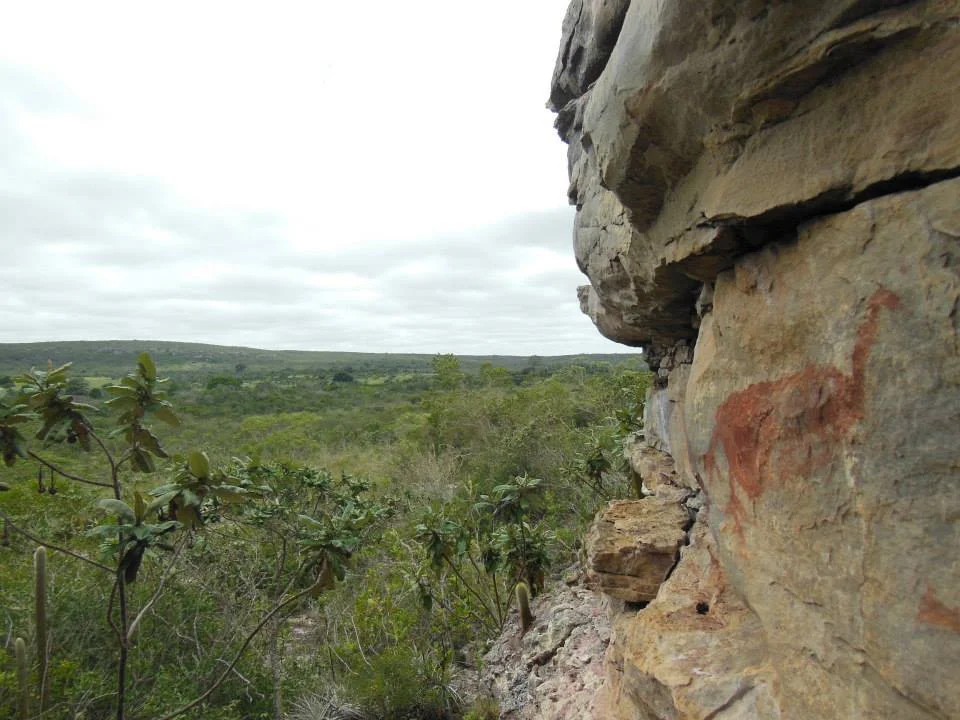
Cave Paintings and Deep Time
Long before the decrees, long before the cattle ranchers, long before the Portuguese came looking for diamonds in the plateau that still bears their name, people lived here. Their paintings survive in four caves the park was meant to guard: Brejões, Boa Esperança, Igrejinha, Cristal. The images are fragile - a fingerprint, a smear of algae, a careless flashlight can damage what sunlight and millennia have spared. Northeast Brazil holds some of the oldest rock art in the Americas; Serra da Capivara, further north, has paintings that may date back more than 20,000 years. The galleries of Morro do Chapéu are a chapter in the same long story. That the park protecting them has been created and erased on paper more than once, while those images stayed exactly where they were, tells you something about which timescales actually matter.
Bureaucracy as Threat and Shield
The story of this park is, in part, the story of Brazilian land tenure. The 1973 decree was never implemented. A state conservation event in 1985 called for action; not much followed. A geological survey in 1995 laid out infrastructure plans. The 1998 decree recreated the park with a new mandate - to protect endangered wildlife, the cerrado-caatinga ecotone, and the archaeological sites. By 2008 a team from the State University of Feira de Santana was redrawing the boundary. By 2011 the park was unsurveyed in much of the west, land owners had not been compensated, roads had been cut through the interior, and hunting and illegal logging went unmonitored. On April 12, 2011, Decree 12.744 extinguished the park. The state prosecutor's office pushed back immediately, citing legal reasons the park had to stand. On May 3, Governor Jaques Wagner signed Decree 12.810, canceling the abolition and giving the Environmental Secretariat ninety days to do the technical work that should have been done decades earlier. As of 2016, land ownership was still not fully regularized.
The Wind-Farm Question
In 2012 a new threat entered the conversation. The hills that channel the caatinga air also channel reliable, powerful wind - exactly the resource that made the plateau attractive to wind-energy developers, and exactly the resource that made it ideal cougar habitat. Environmentalists worried that access roads and foundation blasting would drive out the big cats whose presence is taken by biologists as a sign of genuinely intact wilderness. The Brazilian Wind Energy Association argued the opposite: modern methods allow vegetation to recover quickly, wildlife returns, and the human presence that comes with a wind farm would actually deter the hunters and illegal loggers whom an understaffed park cannot. Neither side was wrong, exactly. The park remains caught between its biodiversity, its human neighbors, its economic potential, and a state that has struggled to choose which of those to honor first.
From the Air
Located at 11.38°S, 41.28°W in the northern Chapada Diamantina of central Bahia. Elevation of the plateau ranges roughly from 600 m in stream valleys to well over 1,000 m on the ridge lines; expect rapid density-altitude changes on summer afternoons. Recommended viewing altitude FL080-FL110 to read the cerrado-caatinga mosaic and the rock outcrops clearly. Nearest airfields: Lençóis (SBLE), about 100 km south, serves tourism into the Chapada Diamantina and has paved runway and limited services; Feira de Santana (SNJD) about 200 km southeast offers a larger alternative. Morro do Chapéu town itself has a small airstrip suitable for single-engine aircraft only. Strong, consistent easterly winds channel through the hills - the same winds that draw wind-farm interest - and can produce mechanical turbulence on lee slopes. Scattered thunderstorms common in the rainy season (November–March); dry-season visibility (May–September) often excellent but hazed by burn smoke in September.
Nearby Stories
- Manuscript 512 75 km away
- Lençóis 107 km away
- Pé de Serra 130 km away
- 1798 Revolt of the Alfaiates 157 km away
- São João de Deus Hospital 243 km away
- Nascentes do Rio Parnaíba National Park 459 km away
- Serra Geral do Tocantins Ecological Station 580 km away
- Crateús 656 km away