Nuri
On the west bank of the Nile, about ten kilometers from the holy mountain of Jebel Barkal, the pyramid of Taharqa was engineered to catch a single beam of light. At sunrise on Egyptian New Year's Day - the morning the annual flood began its journey north - the rising sun, seen from atop Jebel Barkal, would climb directly over the pyramid's point. A pharaoh's tomb aligned to a river's heartbeat. That was Nuri in 670 BCE, when a Nubian king ruled Egypt and decided his resting place would speak to the Nile itself.
A Second City of the Dead
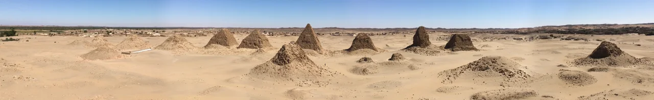
Nuri is the second of three Napatan royal burial grounds. When the older cemetery at El-Kurru ran out of space, Kushite kings looked across the river and chose this stretch of sand and rock as their new necropolis. More than twenty pyramids still stand here, and archaeologists believe as many as eighty once did. For more than three centuries - from Taharqa around 670 BCE to Nastasen around 310 BCE - Kushite monarchs, their mothers, their wives, and their children were laid to rest at Nuri, one generation stacking onto the next. Pyramid 1, Taharqa's, is the oldest and largest: a granite square roughly 51.75 meters on each side, rising 40 to 50 meters into the desert sky. The pyramids here are smaller than the Egyptian ones to the north, but they are unmistakably royal - and unmistakably African.
The Treasures They Left Behind
Time and weather and human hands have worn Nuri down. Many pyramids are heavily degraded, their casing stones stripped, their chapels collapsed. Yet the tombs held on to their dead, and sometimes to their belongings. George Reisner dug here in the early twentieth century and carried out fragments of a lost world - the sarcophagus of King Aspelta, a gold diadem shaped like a flower from the pyramid of King Talakhamani, jewelry still wrapped around the mummy of King Amaninatakilebte. A granite stela from the chapel of Senkamanisken. A shabti figure - a small servant-statue meant to work for the king in the afterlife. These objects now sit in glass cases in Boston, at the Museum of Fine Arts, a long way from home. In 2018, a new expedition under Pearce Paul Creasman returned to Nuri to listen for what the earlier digs had missed.
A Church Built from Royal Stones
Nuri's story did not end when the last king was buried. Centuries later, during the Christian era in Nubia, someone built a church here - and used the pyramid stones to do it. Stelae that had once stood in royal chapels, carved with the names of Kushite kings, were set into new walls to praise a new God. There is something quietly moving about this reuse, this layering. The same sandstone that celebrated Taharqa's confirmation by Amun ended up holding up a roof for medieval Nubian Christians. Faith changed. The mountain stayed. The stones kept working.
What You See From Above
Since 2003, Nuri has been part of a UNESCO World Heritage site that also includes Jebel Barkal and the nearby royal burials at El-Kurru. From altitude, the site reads as a cluster of dark triangles scattered across a pale desert, ten kilometers upriver from the signature flat-topped butte of Jebel Barkal itself. The Nile curves in a wide arc here, the green strip of palms and irrigated fields hugging the water, and then the yellow nothing of the Bayuda Desert begins. The pyramids look small from the air - but so did the Great Pyramid, once, from the right angle. Nuri doesn't advertise itself. It waits.
From the Air
Located at 18.57N, 31.92E, approximately 10 km northeast of Jebel Barkal and 15 km north of Sanam, on the west bank of the Nile near the Fourth Cataract. Recommended viewing altitude: 6,000-10,000 feet AGL for field visibility; the pyramids cluster in a compact area east of the village of Nuri. Nearest major airport is Dongola (HSSW), roughly 180 km downstream to the northwest; Khartoum International (HSSS) is about 400 km to the south. Clear desert air typically gives excellent visibility year-round, though haboob sandstorms can reduce it dramatically in late spring and early summer.
Nearby Stories
- Dar al-Manasir 21 km away
- Nubia 34 km away
- Banganarti 55 km away
- Northern Sudan 64 km away
- Throne Hall of Dongola 68 km away
- R12 (cemetery) 87 km away
- Pyramids of Meroë 211 km away
- Nubian pyramids 233 km away