Parnaíba Basin
Half a billion years of sediment stack up beneath northeastern Brazil, and most of the people who walk across it never think about what lies below. The Parnaíba Basin is an ellipsoidal depression that covers over 600,000 square kilometers - larger than the state of California - and holds about 3.4 kilometers of mostly Paleozoic rock. About half its area sits inside the state of Maranhão. The rest spills into Pará, Piauí, Tocantins, and Ceará. The basin is named for the Parnaíba River, which runs roughly 1,400 kilometers parallel to the basin's long axis before emptying into an open-sea delta on the Atlantic. What is visible at the surface is merely the latest chapter of a geological story that began when the supercontinent Rodinia broke apart.
Between Cratons
The basin sits between major ancient continental blocks. To the west lies the Amazonian Craton, one of South America's great Precambrian cores. To the southeast, the São Francisco Craton anchors much of central Brazil. The smaller São Luís Craton sits to the north, and the Borborema Province extends to the east. Between them, the Parnaíba block exists as a hypothesized continental fragment - its existence inferred from geophysical surveys, from the petrography and geochronology of deep basement rocks, and from models of collisional tectonics. It is believed to be one of the fragments the South American platform inherited when the Rodinia supercontinent broke apart, later joining the assembly that became Gondwana. The Araguaia suture zone to the west marks the final Neoproterozoic collision between the Amazonian craton and the Parnaíba block. The Transbrasiliano Lineament to the east marks a crustal-scale fault separating the basin from the Borborema Province.
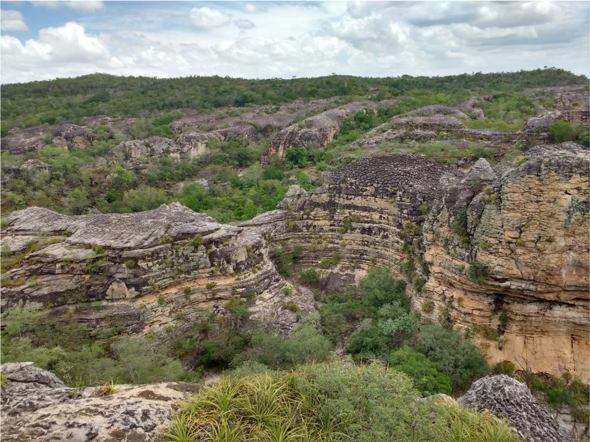
Five Chapters Written in Stone
Geologists divide the basin's sedimentary fill into five tectonostratigraphic units, each bounded by basin-wide unconformities where erosion or non-deposition interrupted the record. The oldest is the Riachão unit (TS-1), followed by the Jaibaras unit (TS-2). The bulk of the basin belongs to the Parnaíba unit (TS-3), spanning the Late Ordovician through the Early Triassic - deposits laid down between roughly 445 and 220 million years ago. The Mearim unit (TS-4) covers subsequent deposition. The youngest is the Grajau unit (TS-5), made up of the Corda, Grajau, Codó, and Itapecuru formations, deposited during the Cretaceous between 120 and 95 million years ago. This youngest fill is tied to the opening of the South Atlantic, when subsidence along Brazil's future coast made room for more sediment. Each layer records the shifting environment: sometimes shallow marine, sometimes freshwater, sometimes terrestrial.
Two Rivers of Magma
The sedimentary rock record is punctuated by two distinct magmatic pulses. The older one, the Mosquito Formation, erupted mostly as sills and dikes of sub-alkaline tholeiitic basalt during the Jurassic, coincident with the opening of the central Atlantic Ocean as Pangaea broke up. The younger pulse, the Sardinha Formation, emerged between roughly 130 and 125 million years ago during the Middle Cretaceous. It also appears as diabase dikes and sills, along with minor basaltic flows, but its lavas carry higher alkali content than the Mosquito Formation rocks. Both pulses reflect moments when the crust beneath the basin fractured enough to let mantle-derived melt rise through the sedimentary pile. Today those ancient dikes and sills appear as dark ridges cutting through lighter-colored sandstones and shales, visible at outcrops across the basin.
The Sag That Made the Basin
The Parnaíba Basin is classified as a cratonic basin, meaning it formed on a stable continental interior rather than at a plate boundary. The exact mechanism of the initial subsidence is debated among geologists, with three main models. One interprets the basin's main infill as the product of slow basinal sag - gentle, long-duration subsidence of cratonic crust. Another ties it to Cambro-Ordovician rifting events that thinned the crust and allowed later sediment to accumulate. A third reads it as a pull-apart structure formed by dextral strike-slip motion on the Transbrasiliano shear zone during the Cambrian and Early Ordovician, or perhaps as a remnant foreland basin bounded by thick-skinned thrust faults. What everyone agrees on is that the basin stabilized during the Brasiliano orogeny, and thermal evidence suggests the main subsidence episodes occurred 70 to 90 million years ago.
A Landscape That Hides Its Age
Fly over Maranhão and Piauí and the Parnaíba Basin does not announce itself. The surface looks like any other sequence of low plateaus, river valleys, and scrub-covered highlands. The Chapada das Mangabeiras to the south, the Serra das Alpercatas and Serra do Tiracambu in the interior, even the riverbeds of the Parnaíba and its tributaries - all are expressions of rocks deposited in seas and rivers that vanished hundreds of millions of years ago. The basin also holds modern economic interest. Natural gas production in the Parnaíba basin runs to 8.4 million cubic meters per day, feeding thermal power stations in Maranhão. What you see from altitude is a landscape where deep time is written in every scarp and river valley, and where geologists continue to read chapters whose first words were composed when the world looked nothing like this one.
From the Air
Basin centroid at approximately 6.47°S, 45.58°W. Covers over 600,000 km² across Maranhão (~50%), Pará, Piauí, Tocantins, and Ceará states. Recommended viewing altitude 30,000-37,000 feet for basin-scale features. Visible from altitude: the ellipsoidal shape of the basin bounded by the Amazonian Craton exposures to the west and São Francisco Craton to the southeast; the Parnaíba River running roughly parallel to the basin's long axis; plateau escarpments including Chapada das Mangabeiras; the darker vegetation signatures that sometimes trace ancient dike and sill systems. Main regional airports: Teresina (SBTE) in the east, Imperatriz (SBIZ) in Maranhão, and São Luís (SBSL) on the coast.
Nearby Stories
- Chapada das Mesas National Park 126 km away
- Juscelino Kubitschek de Oliveira Bridge 156 km away
- Parnaíba Thermal Power Complex 164 km away
- Serra dos Martírios/Andorinhas State Park 274 km away
- Santa Inês 277 km away
- Teresina 283 km away
- Nascentes do Rio Parnaíba National Park 377 km away
- Manuscript 512 602 km away