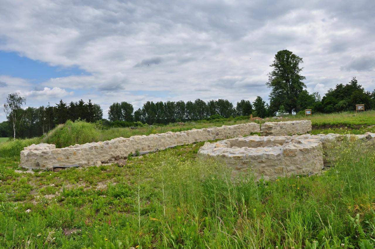

Royal Palace of Werla
In 1937 an aircraft from the army flying school at Hildesheim made a series of passes over farmland near Schladen, photographing the same ground twice from slightly different angles. Seen in stereo, the prints showed what nobody standing in the field could see: faint discolourations tracing walls, ditches and gates across roughly six hundred metres in each direction. The lost palace of Werla — where Saxon kings had sheltered, conferred and been chosen — had lain under a plough for six centuries. The discovery was genuinely sensational. What was done with it was not.
The King Who Bought Nine Years
Werla sits on the Kreuzberg, a natural plateau seventeen metres above the Oker, with two sides of the fortress dropping straight to the river bank. That is why anyone built here. It was not a palace in the later sense but a Pfalz — one of the fortified stops where an itinerant early-medieval kingship came to rest, ate the district's surplus, gave judgement and moved on.
Its first appearance in the record is a crisis. The Saxon chronicler Widukind of Corvey describes King Henry the Fowler taking refuge here with an untrained army in the face of a Hungarian attack, in either 924 or 926, depending on the reading. A Hungarian leader was captured at the same time, and Henry traded him back for a nine-year truce — nine years he spent building fortifications and training the cavalry that would eventually meet the Hungarians on better terms. One of the more consequential ransoms in German history, negotiated from a hill above a river.
Fourteen Visits
Fourteen royal stays are documented at Werla between 924 and 1013. Every Ottonian ruler came at least once; Otto the Great is recorded here five separate times. For a kingdom with no capital, that concentration is the closest thing to a statement about where power actually lived.
Twice the succession itself was settled on this ground. In the crisis of 1002, after Otto III died childless, it was at Werla that the Saxon magnates accepted the Bavarian duke Henry as his successor. Before the election of Conrad II in 1024 the Saxons met here again to talk among themselves first. Four such assemblies are known — not a regular parliament, but a habit, and a revealing one. When the north of the Empire needed to decide something without the rest of the Empire in the room, it came to this plateau.
Silver Wins
What ended Werla's political career was a mountain. The newly founded palace at Goslar controlled the silver of the Rammelsberg, and a court will always drift toward money. Under Henry II the centre of gravity had already shifted south.
But losing importance is not the same as dying. Through the eleventh and twelfth centuries the first bailey was expanded westward and given a new secondary keep, a second outer bailey was added, and the enclosed area grew to nearly twenty hectares. Sunken-floored buildings in the baileys held metal and textile workshops. What had been a place kings visited became a place people lived and worked. The old symbolism did not evaporate either: in 1180, Frederick Barbarossa came to Werla to close out his conflict with Henry the Lion and issue an ultimatum to Henry's followers. He chose a palace a century out of fashion, close to his enemy's own city, precisely because the Saxons still knew what it meant.
Cradle of the First Reich
By the fourteenth century Werla was ruins, and then it was nothing. Nineteenth-century scholars hunted for it in Mecklenburg and Westphalia before documentary work narrowed the search to Schladen, where farmers had been ploughing up stones on the Kreuzberg for years. A trench in 1875 found foundations; a stone was set up and a lime tree planted, which still stands.
Serious excavation began in 1934, and in 1937 the project was handed to Hermann Schroller — a prehistorian, not a medievalist, and a party member with the contacts to get things done. He secured labour from the Reichsarbeitsdienst and aircraft from the army flying school, and he walked officials and school classes around the trenches. Werla was publicised as the "Cradle of the First Reich," an ancestor the regime had decided to claim. Finds were pushed toward the Ottonian period wherever possible, and preferably toward Henry I, the designated founder-figure. Some of the resulting errors are still being untangled from the literature.
Digging It Out Twice
Excavation resumed in 1957 under Schroller, and after his death in 1959 his students Gudrun Stelzer and Carl-Heinrich Seebach carried it to 1964. Thousands of finds came up: pottery above all, iron and bronze work, and coins from Rostock, Göttingen and Bremen, mostly thirteenth-century. Notably absent was the debris of royal visits — the kings left their mark in construction, not in litter.
One early theory died in those trenches. The baileys had been assumed to be army-forts, pure military overflow; the workshops found there disproved it. Werla stopped being read as a bulwark against Hungarians and started being read as what it more usually was, a regional centre of government and craft. Fresh excavations from 2007 attacked outworks earlier campaigns had barely touched, and on 14 September 2012 the site opened as the Archäologie- und Landschaftspark Kaiserpfalz Werla, with walls, gates and building outlines partly reconstructed above ground. There is still no road to it. You park on the lane between Schladen and Werlaburgdorf and walk in, which is roughly how everyone arrived for the first thousand years.
From the Air
Werla lies at 52.0377°N, 10.5548°E, on the Kreuzberg plateau between Schladen and Werlaburgdorf in Lower Saxony, about 15 km south of Wolfenbüttel and northeast of Goslar. From 1,500–3,000 ft the outline is unusually legible for an archaeological site: the reconstructed enceinte and gates draw a pale geometric figure on open farmland, seventeen metres above the Oker, with the river hard against two sides of the plateau and no road running to it. Braunschweig-Wolfsburg (EDVE) is roughly 35 km north; Hannover (EDDV) about 90 km northwest; Magdeburg-Cochstedt (EDBC) around 45 km east-southeast. The Harz massif rises immediately to the south and southwest — expect mechanical turbulence and lee wave activity in strong southwesterlies, and rapidly worsening cloud bases on the northern slopes. Low sun in early morning or late afternoon rakes the earthworks and is by far the best light for seeing the ground plan from the air.
Nearby Stories
- Wernigerode Castle 5.7 km away
- Wolfsburg 6.3 km away
- Battle at the Harzhorn 6.7 km away
- Hildesheim Cathedral 17 km away
- Gardelegen Massacre 21 km away
- Sack of Magdeburg 25 km away
- Celle State Stud 27 km away
- Eisleben 43 km away