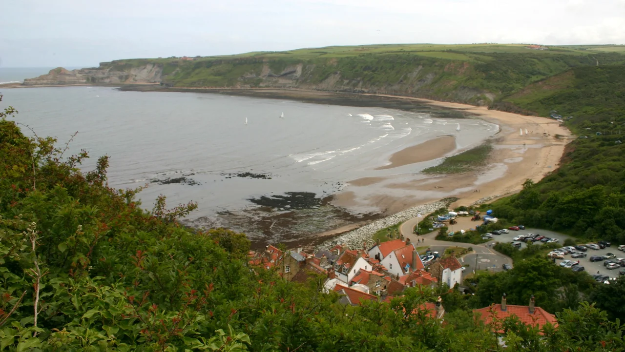

Runswick Bay
One night in 1682, two mourners sat up with a body at a wake in the old village of Runswick Bay. They felt the floor shift under them. They felt it again. They went outside, knocked on doors, dragged neighbours from their beds - and watched the rest of the village slide off the cliff into the North Sea. Not a single person died. Every house, almost, was lost. The villagers rebuilt slightly to the south, terracing their new cottages into the cliffside in tight switchbacks, with one car-impassable road at a one-in-four gradient. Runswick Bay is what they built. It is still there because it has continued to fight, with seawalls and engineering reports, against the same slope that swallowed its predecessor.
A Crescent of White Sand
Five miles north of Whitby, Runswick Bay is two kilometres of pale sand wrapped between Cauldron Cliff to the north and the headland of Kettleness to the south. From above - from the Cleveland Way that runs along the cliff - the village looks like a child's painting: red pantile roofs stacked on the slope, white walls, a single track down to the beach. The Sunday Times named it Beach of the Year in 2020. Fossil hunters comb the shore for ammonites weathered out of the Jurassic shale. A small thatched cottage halfway down the cliff is Grade II listed, and the old lifeboat house at the bottom is now run by volunteers who launched their own boat in 1982 after the RNLI moved operations to Staithes.
The Hob in the Cave
Around the edge of the bay are sea caves, and the largest of them is called Hob Hole. A hob, in North Yorkshire folklore, is a household spirit - sometimes helpful, sometimes a nuisance, related to the boggarts and brownies of older mythology. The Runswick Hob was said to live in this cave and to cure children of whooping cough if their mothers brought them down at low tide and called for him. The cave is genuinely impressive: a high-arched opening in the shale where the tide rushes in. The hob is presumably wherever hobs go when the tourist season starts. Above the village, a hamlet called Runswick Bank Top sits among farmland with a caravan site and a hotel, joined to the lower village by a single steep lane that is part of the Cleveland Way.
The Painters of 1880
In the late 1880s, around the time when French artists were colonising the fishing villages of Brittany and Normandy, an English equivalent emerged at Runswick Bay and neighbouring Staithes. Around fifty painters - the Staithes Group, sometimes called the Northern Impressionists - made these two villages their summer home, painting en plein air in oils and watercolour. Dame Laura Knight and her husband Harold Knight spent years here. The light off the North Sea, the working fishermen mending nets along the cobles, the steep narrow lanes and limewashed walls: it was as paintable a subject as anything in France, and Yorkshire patrons bought the results. The colony faded with the First World War, but the village they painted is still recognisable in the village you walk through today.
The Hectare Holdings
Most of the village land is still owned by the Marquess of Normanby's Mulgrave Estate, just inland at Lythe - the same family that has held Mulgrave Castle for three centuries. The 620 hectares of village include 1,875 permanent residents within the wider parish of Hinderwell, but a peak seasonal population of 2,315, the difference made up of holiday lets and second homes. From 1866 to 1978 Runswick ran its own RNLI lifeboat; the boathouse still stands, and a volunteer rescue service has operated from it since 1982. Streams called Nettle Dale, Dunsley Dale, Calais Beck and Widgeytoft Gill drain across the sands. The names are older than the village. The seawall is younger - completed in 1970, then reinforced in 2018 with a £2.28 million scheme designed to hold off the sea for another hundred years.
Always the Slope
The cliff that ate the old village in 1682 has not stopped moving. The geology here is Jurassic shale and clay, soft and saturated, prone to slip whenever the rainfall is heavy enough or the sea persistent enough. Up the coast at Kettleness, alum was mined from 1727 to the late 1800s, quarrying the same unstable shale; the ruined workings are still visible from the clifftop path between Runswick and Skinningrove. Down the coast at Staithes, similar slips have eaten away at the old fishermen's quarter. Runswick survives by engineering - the seawall, the protection scheme, the constant maintenance - and by accepting that the slope is the price of the view. The bay is what it is because the cliff keeps almost-but-not-quite falling.
From the Air
Runswick Bay sits at 54.53164 degrees N, 0.7448 degrees W, on the North Yorkshire coast. Nearest aviation reference is Teesside International (EGNV) about 45 km northwest; Durham Tees Valley airspace governs the area. From 2,000 to 3,500 ft AGL on a clear day the bay forms an unmistakable crescent of white sand between Cauldron Cliff to the north and Kettleness headland to the south, with the red-roofed village pinned to the western cliff. Whitby is 8 km southeast - the abbey on East Cliff is a useful navigation cue. Best light is mid-morning, when the sun reaches into the bay from the east and lights the cliffside village without harsh shadow.
Nearby Stories
- Ryedale Folk Museum 3 km away
- 1892 Thirsk Rail Crash 5.5 km away
- Penshaw Monument 6.5 km away
- Darlington 12 km away
- Filey Brigg 12 km away
- German submarine U-2367 28 km away
- Seaham Hall 30 km away
- Battle of Flamborough Head 49 km away