Santos Dumont, Minas Gerais
For most of its life, this town was called Palmira. Then in 1934, the Brazilian government renamed it Santos Dumont in honor of the man born sixteen kilometers outside its center - Alberto Santos-Dumont, the balloonist and aviator who flew his 14-bis over a field in Paris in October 1906 and, in Brazilian eyes, invented powered aviation. The name change was an act of national memory. Outside Brazil, the Wright brothers get the credit for the first powered flight in December 1903. Inside Brazil, Santos-Dumont does, because the Wrights used a catapult for takeoff and Santos-Dumont's aircraft rose under its own power alone. The argument has not cooled in a hundred and twenty years, and the birthplace town carries the pioneer's name into every road sign, bus ticket, and bank document.
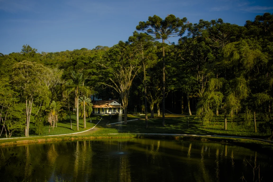
Cabangu Farm
Sixteen kilometers from the center of the modern town, in the district of Mantiqueira, stands the Cabangu farmhouse where Alberto Santos-Dumont was born on 20 July 1873. His father was a wealthy coffee planter and engineer; his mother came from an old Minas Gerais family. The house is now the Cabangu Museum, dedicated to its most famous son. Inside are personal objects, photographs, models of his aircraft, and a small aviation museum. Santos-Dumont left Brazil as a young man, studied in France, and built the career that made him a world celebrity in the early 1900s - first through his navigable balloons, then through his heavier-than-air flights in Paris. He returned to Brazil periodically, famous and restless, and died in 1932 at age 59 by his own hand, grieving what aviation had become during the First World War and the Paulista revolt. Two years later, his birthplace took his name.
Palmira Before and After
The town that is now Santos Dumont was called Palmira and became a city in 1889 - the same year the Brazilian monarchy fell and the republic was proclaimed. It had grown up along an important colonial route and by the late nineteenth century was a coffee-and-livestock market town on the main road between Rio de Janeiro and the central Minas Gerais mining country. The renaming in 1934 did not change the physical town much. Palmira had always been, and Santos Dumont remains, a place defined by its position - 839 meters elevation, pressed between the urban centers of Barbacena to the north and Juiz de Fora to the south, just off the BR-040 interstate highway. The city is 240 kilometers from the state capital Belo Horizonte and 220 from Rio de Janeiro. It has never been large. In 2020 the population was estimated at 46,421.
Cattle and Demography
Livestock raising dominates the municipal economy - roughly 30,000 head of cattle and an annual milk production of about 15 million liters. The land also yields corn, strawberries, guava, nectarines, manioc, beans, oranges, coffee, peaches, and bananas. Industry is smaller but present: the Companhia Brasileira de Carbureto de Cálcio (CBCC) produces silicon iron and metallic silicon, much of it exported. Since the 1980s, Santos Dumont has been in slow demographic stasis. Between the 1996 and 2000 censuses, the population grew at only 0.32 percent annually - far below the national rate - partly because nearby Juiz de Fora has stronger economic pull and absorbs many of the region's in-migrants. According to the 2000 census, 38.8 percent of workers earned less than the national minimum wage (R$151, or 80 US dollars at the time). The town is not prosperous. It persists.
The Royal Road Still Runs
A ten-kilometer stretch of the Estrada Real - the colonial Royal Road that carried gold and diamonds from the Minas Gerais interior to Rio de Janeiro - runs through the municipality toward the neighboring town of Antônio Carlos. Two stone fountains survive from the road's working period, built for the drovers who led mule trains loaded with gold. Rock inscriptions, left by travelers long since dust, still mark the trail. The Royal Road closed to official traffic after independence and the fading of the gold economy, but the physical path survived, and in recent decades it has been revived as an ecotourism route. Santos Dumont markets this pilgrimage-walk-meets-hiking-trail among its attractions. There are old farms along the way, natural landscape that still looks close to what the drovers saw, and the slow feeling of a trail that once mattered to an empire.
Where the Father of Flight Was Born
If you fly over this part of Minas Gerais, you can pick out the town in the saddle of the Mantiqueira range, between darker hills and the ribbon of the BR-040 highway. The Ponte Preta Dam lies on the outskirts, offering swimming, boating, fishing, and camping when full; in the dry months from September to January, the dam empties and the exposed bed becomes the venue for off-road events. The Cabangu farmhouse sits in the district of Mantiqueira, and if the weather is clear you can sometimes pick out its white walls among the coffee-country green. A boy was born there in 1873 who would never quite fit any country - Brazilian, Parisian, restless, obsessive - and who gave the world the idea of the aircraft as a private machine. The town that bears his name keeps watching his sky.
From the Air
Coordinates 21.46°S, 43.55°W place Santos Dumont in southern Minas Gerais, 240 km south of Belo Horizonte and 220 km north of Rio de Janeiro, at 839 m elevation. Recommended viewing altitude 4,000-6,000 feet AGL. The BR-040 highway runs through the region, connecting Barbacena and Juiz de Fora. Nearest airport is Regional da Zona da Mata (SBZM) at Juiz de Fora, about 40 km south. A small airport named in honor of Santos-Dumont - Santos Dumont Airport (SBRJ) - is in Rio de Janeiro, but it is not near his birthplace town. The Cabangu farmhouse museum is 16 km from the town center.
Nearby Stories
- Leopoldina, Minas Gerais 26 km away
- Tiradentes 30 km away
- Hospital Colônia de Barbacena 39 km away
- Paraiba do Sul, Rio de Janeiro 43 km away
- Church of Saint Francis of Assisi (Sao Joao del-Rei) 55 km away
- Muriaé 57 km away
- Nova Friburgo 66 km away
- Visconde de Mauá, Resende 85 km away