
Shorncliffe Redoubt
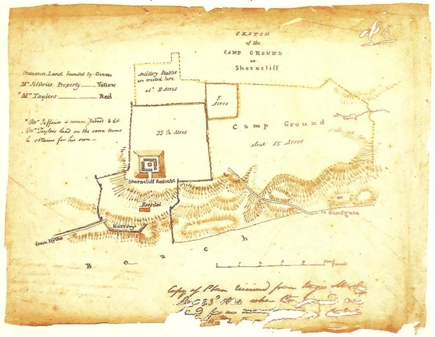
The locals could see the smoke. Twenty miles south, across the Strait of Dover at Cap Gris Nez, Napoleon's invasion army camped on the French coast - the Army of England, more than 100,000 men assembled for an invasion of Britain that, in the end, was never launched. But for years the threat felt entirely real, and on certain clear evenings the people of Sandgate, Folkestone, and Hythe could look across the Channel and watch the campfires of the men coming to kill them. Britain's land-based defences in the 1790s were, by parliamentary admission, woefully inadequate - the Royal Navy had carried the country's defence for two centuries, and almost no army existed to meet an invader who got past the fleet. So in 1794 Parliament purchased a large piece of land at Shorncliffe and dug a fort. A simple earthwork, 300 feet by 300 feet. A redoubt.
When the Smoke Was Real
On 21 January 1793, the French Revolutionary government executed King Louis XVI. Marie Antoinette followed in October. Two weeks after the king's death, on 1 February, the French Republic declared war on Great Britain. Britain braced for invasion. Most British troops were stationed abroad. The Royal Navy was strong but couldn't hold a coastline by itself. The Kent coast, twenty miles from France at its narrowest, was the obvious landing ground. Parliament bought the Shorncliffe site as the obvious place to build initial fortifications. Colonel William Twiss - the same military engineer who would later redesign Sandgate Castle as a Martello tower - drew up the plans. The redoubt was completed in stages from 1794 onward, paired eventually with the 28-mile Royal Military Canal (construction started October 1804 from Seabrook, completed April 1809 to Cliff End near Hastings), with a chain of 74 Martello towers along the south coast built between 1805 and 1808, and with various other earthworks intended to slow any French landing long enough for British forces to concentrate.
The Engineering of a Berm
What makes Shorncliffe interesting to military engineers is the way its earthwork walls were built. Earlier earthworks - including most of the redoubts of earlier centuries - were simply piled-up dirt. You dug a ditch and threw the spoil into a wall, which put topsoil at the bottom and the stonier subsoil at the top. That worked well enough before cannon, but heavy artillery could shake those walls apart. The Shorncliffe walls were built differently. The turf was lifted and set aside. The topsoil was lifted next. The stony substrate beneath was used to form the core of the wall - a layer at a time, with topsoil laid over each layer and compacted before the next stony layer was added. The turfs were then placed at the foot of the mound to stabilise it and promote grass growth as weather protection. The result was a wall with strong foundations and layered structure, much better able to absorb cannon impact than the older piled-earth designs. The defensive ditches dug around the redoubt were about five metres deep. With the earthen ramparts above them, the fort was genuinely well defended.
Sir John Moore's School
What made Shorncliffe historically important was not the fort itself but the regiments that trained on the ground around it. In 1802, Sir John Moore - one of the great British military trainers of the age - was stationed at Shorncliffe and began developing what came to be called light infantry tactics. Moore trained the 43rd Monmouthshire Regiment of Foot, the 52nd Oxfordshire Light Infantry, and the famous 95th Rifles - the green-jacketed riflemen who would later become the heroes of Bernard Cornwell's Sharpe novels. Where the regular British line infantry fought shoulder-to-shoulder in massed ranks, the light infantry Moore trained at Shorncliffe fought in dispersed order, used cover, took aimed shots rather than mass volleys, and operated as skirmishers and scouts ahead of the main army. The Baker rifle they carried was accurate at four times the range of the smoothbore musket. The Light Division formed around these regiments would distinguish itself across the Peninsular War in Spain and Portugal, and the tactics Moore developed at Shorncliffe would shape British infantry practice for generations. Moore himself died at the Battle of Corunna in January 1809, covering the British army's evacuation from Spain. The 95th Rifles carried his coffin to its grave.
A Star Fort That Was Never Built
Some early maps of the site show a much larger star fort - heavily fortified magazines, an elaborate geometric design. Archaeological digs have failed to find any trace of them, because they were never built. The maps were preliminary guidelines for an expansion the army abandoned when Colonel Coote Manningham and Sir John Moore reshaped infantry doctrine. Why build an enormous bastioned fort if your light infantry would no longer fight from behind walls? Shorncliffe Army Camp, the working military installation that grew up next door, remains in use today. The redoubt itself has fallen into disrepair. The popular Channel 4 archaeology programme Time Team filmed an episode at Shorncliffe that first aired on 1 May 2007. During the First World War the Shorncliffe Camp Song was sung by recruits - 'Down in Shorncliffe Camp', set to the tune of 'Back Home in Tennessee' by W.M. Jerome and Walter Donaldson, 1915 - the kind of song young men sing when they're about to be sent across the Channel themselves. The fort built to keep Napoleon out had become, by 1916, a way-station for the British soldiers crossing in the opposite direction, toward the trenches of the Western Front.
From the Air
Shorncliffe Redoubt sits at 51.076°N, 1.129°E on the Kent coast at Sandgate, immediately northwest of the modern Shorncliffe Army Camp. From the air, look for the square earthwork - roughly 300 feet on a side - on rising ground above the coast between Sandgate and Folkestone. Shorncliffe Army Camp lies adjacent to the east. Sandgate Castle is 1 km south on the coast; Folkestone harbour is 3 km east. The Royal Military Canal terminates near Seabrook 2 km southwest. Nearest airport is London Ashford (Lydd) (EGMD) about 23 km southwest. The redoubt is in disrepair but its outline remains visible from low altitude.
Nearby Stories
- HMS Hermes (1898) 7.3 km away
- Herne Bay Museum and Gallery 8.5 km away
- Benenden School 9.2 km away
- Boulonnais 9.4 km away
- Priestfield Stadium 12 km away
- 1382 Dover Straits Earthquake 17 km away
- Royal Sovereign Lighthouse 21 km away
- Battle of Boulogne 28 km away