The Park That Saved Itself
On a clear night at Sugarloaf Ridge State Park, you can look through the 40-inch telescope at the Robert Ferguson Observatory and see the rings of Saturn. The observatory is entirely volunteer-run -- no government funding, no paid staff, just amateur astronomers who show up on weekends to open the dome and point the instruments at whatever is worth seeing. This spirit of stubborn volunteerism defines Sugarloaf Ridge. When California announced in 2011 that the park would be among the first to close in a wave of budget cuts affecting up to 70 state parks, it was volunteers who stepped in. Team Sugarloaf reopened the gates in June 2012, proving that a community can love a place fiercely enough to keep it alive when the institutions responsible for it walk away.
Where Two Counties Meet
Sugarloaf Ridge straddles the boundary between Sonoma and Napa counties in the Mayacamas Mountains, northeast of the small town of Kenwood. The ridge has two main peaks: the southern one rises to 1,939 feet and bristles with microwave antennas, while the northern peak reaches 2,265 feet and offers nothing but a bench and two interpretive panels identifying the landmarks visible in every direction. It is the kind of park that rewards elevation. From Bald Mountain, the highest point at 2,729 feet, the view unfolds across Mount Saint Helena to the north, the Napa Valley to the east, and on clear days, the Sierra Nevada far to the southeast. Turn south and the San Francisco Bay Area spreads out below, with Mount Diablo anchoring the horizon. Twenty-five miles of trails thread through the park, ranging from gentle creekside walks to the 8.8-mile Bald Mountain loop with its 2,500 feet of elevation gain.
Charcoal Burners and Gentlemen Farmers
The Onasati, a group within the Wappo people, were the first known inhabitants of this region, settling along Sonoma Creek roughly 1,500 years ago. They harvested acorns and berries and developed sophisticated farming and basketry traditions. Spanish incursions began in 1823, and by the 1870s the character of the ridge had changed entirely. Business owners from nearby towns hired what were called "gentlemen farmers" to manage ranches along the ridgeline -- a genteel arrangement that left the actual landowners free to remain in town while their employees worked the steep terrain. Others found a less refined livelihood: burning the ridge's trees to produce charcoal for sale. The landscape they left behind eventually recovered, and today the slopes that were once stripped for fuel erupt each spring in wildflowers -- California poppies, lupines, shooting stars, trilliums, and the delicate golden fairy lantern that grows in only certain pockets of the park.
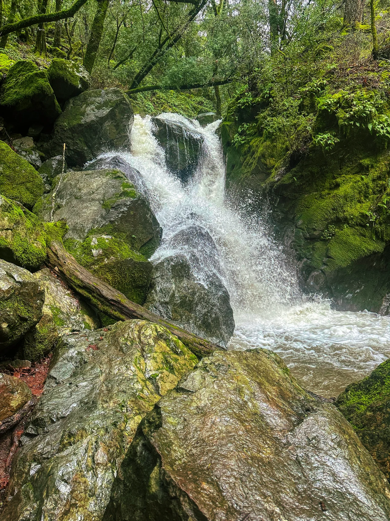
The Waterfall and the Creek
Sonoma Creek begins here, gathering its headwaters from the ravines and springs of Sugarloaf Ridge before flowing southwest through Kenwood and the Sonoma Valley toward San Pablo Bay. The park's 25-foot seasonal waterfall appears during the rainy months between November and April, when an average of 40 inches of rain transforms the dry creek beds into rushing channels. Trout populate the streams from late spring into early summer, drawing anglers who share the creekbanks with deer, gray foxes, and the occasional black bear. Bobcats and mountain lions patrol the higher elevations, though sightings are rare enough to feel like a gift rather than a threat. Turkey vultures circle overhead in loose, tilting spirals, riding the thermals that build against the ridge as the day warms. The park receives occasional snowfall in winter -- a surprise to visitors who associate Sonoma County with sun and wine rather than frost and silence.
Stars Over Wine Country
The Robert Ferguson Observatory sits in a meadow near the park entrance, its silver dome conspicuous against the oak-studded hills. Founded by volunteers in 1995, it is the largest observatory in the western United States dedicated exclusively to public viewing. The location was chosen for its relative darkness -- far enough from the light pollution of Santa Rosa and Napa to offer genuinely dark skies, close enough to population centers that families can drive up for an evening program. The observatory hosts regular star parties, solar viewing sessions, and educational programs, all staffed by volunteers who rotate through the telescope positions with the practiced ease of people who have been doing this for years. In a valley increasingly defined by tasting rooms and resort hotels, the observatory offers something different: a reason to visit Sonoma County after dark, and a reminder that the most spectacular thing in wine country is not on the ground but overhead.
From the Air
Located at 38.44N, 122.50W in the Mayacamas Mountains northeast of Kenwood. Bald Mountain (2,729 ft) is the prominent summit. The park straddles the Sonoma-Napa county line. Nearest airports: Sonoma County Airport (KSTS) approximately 15 nm northwest, Napa County Airport (KAPC) approximately 15 nm east. Terrain rises sharply from the valley floor; maintain safe altitude over the ridgeline. Mountain weather can shift quickly, with morning fog common in the valleys below and occasional winter snowfall at the higher elevations.
Nearby Stories
- Sonoma Coast State Park 5 km away
- Engine Number 5 and the Tunnel That Kept Its Secret 5 km away
- The Canyon That Burned on Independence Day 6.5 km away
- Museum of the American Indian 8 km away
- California's Holland 16 km away
- Griffith Mansion 17 km away
- Where the Sheep Rancher Planted Stars 29 km away
- Cordell Bank: The Invisible Island 29 km away