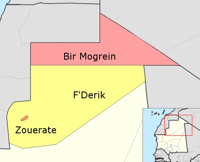

Tiris Zemmour
A train more than two kilometers long crawls out of the desert at Zouérat, loaded with iron ore the color of dried blood. It will travel some 700 kilometers to the Atlantic, and along the way a few travelers will do something that sounds reckless and is: they will climb aboard the open ore cars and ride for free across the Sahara, faces wrapped against the grit, the night sky vast above them. This is Tiris Zemmour, the northernmost region of Mauritania, where the economy of an entire country runs on a single iron rail.
The Mountain That Was Iron
Geologists came to the hills near Zouérat in 1952 and found something extraordinary: deposits of iron ore so rich they would eventually anchor Mauritania's economy. The mines around Fderîck and the Kediet ej Jill massif began producing in the early 1960s, and the ore has been moving ever since. In 1974 the Mauritanian government nationalized the mining operation, taking control of the resource that had drawn foreign capital into one of the emptiest corners of the Sahara. Zouérat, the regional capital, grew up around the work, a town of mineworkers and their families pressed against the rust-red hills. Today it is the largest town in northern Mauritania, an improbable city in a region where the desert otherwise allows almost nothing to take root.
The Longest Train
The Mauritania Railway opened in 1963, a single line running 704 kilometers from the mines at Zouérat to the port of Nouadhibou on the Atlantic coast. It exists for one reason: to carry iron ore to the sea. The freight trains that make the run are among the longest in the world, sometimes stretching more than two and a half kilometers, their ore cars rumbling across a landscape of sand and stone where there are no towns, no water, almost nothing at all. The same line brings the desert what it cannot make for itself. Drinking water for the region rides the rails inward from Boulenoir, because in Tiris Zemmour even water must be imported.
A Land of Extremes
Almost all of Mauritania is desert, and Tiris Zemmour is its harshest expression. Daytime temperatures average near 38 degrees Celsius, yet desert nights can plunge to freezing. Rainfall in the north, close to the Tropic of Cancer, amounts to barely 100 millimeters a year, and even that has been shrinking. Researchers have tracked the Sahara's southward creep, noting that rainfall here has fallen since the 1960s, when the region still caught close to 250 millimeters. Shifting dunes form temporary ranges and then dissolve. The land tolerates oases in scattered hollows, but little else. Among the dunes and gravel plains, a population of slender-horned gazelle still finds a way to survive.
People of the Sand
For centuries the people of Tiris Zemmour were nomads, moving their herds across the desert in rhythm with the seasons and the rare rains. Then came the great droughts of the 1970s and early 1980s, which broke the old pattern. Families who had wandered the open desert for generations gathered instead in the towns, in Zouérat and Fderîck and Bir Moghrein, trading the freedom of the tent for the certainty of work and water. The region remains thinly peopled, around 53,000 souls spread across an enormous territory bordering Algeria, Mali, and Western Sahara. The literacy rate is surprisingly high for so remote a place. The desert that shaped these lives is patient, and it does not forgive carelessness, but the people who remain have learned to read it.
From the Air
Tiris Zemmour spans the far north of Mauritania, centered roughly at 24.0°N, 9.0°W. From altitude, look for the rust-colored iron hills around Zouérat and the thin scratch of the Mauritania Railway running west toward the Atlantic coast at Nouadhibou. The terrain is open Saharan desert: linear dunes, gravel plains, and isolated massifs, with excellent visibility in dry conditions and frequent dust haze when the harmattan blows. Nearest major coastal airport is Nouadhibou (GQPP / GQPA) to the west; Tindouf, Algeria (DAOF) lies to the north-northeast. Recommended viewing altitude FL250–FL350 for the full sweep of dunes and rail line.
Nearby Stories
- Tenoumer Crater 130 km away
- Bir Lehlou 233 km away
- Tifariti 264 km away
- Empire of Great Fulo 284 km away
- Erg Iguidi 309 km away
- El Djouf 315 km away
- Sahara International Film Festival 382 km away
- Sahrawi refugee camps 403 km away