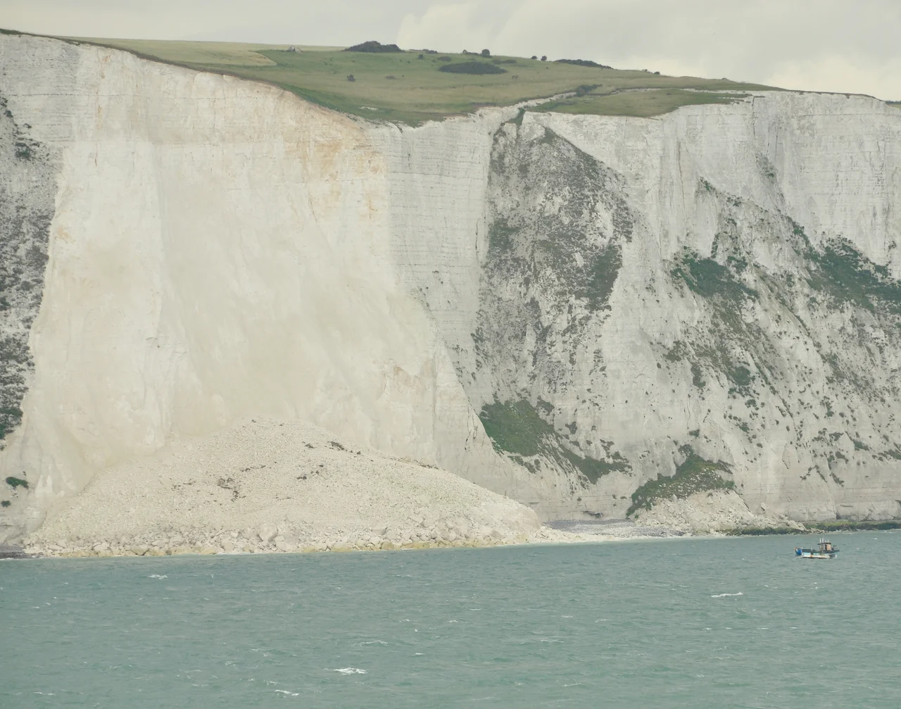

White Cliffs of Dover
Every wall of the White Cliffs is the corpses of plankton. The microscopic single-celled algae called coccoliths floated in a warm Cretaceous sea between 100 and 66 million years ago, made their tiny calcium-carbonate skeletons, and when they died, drifted to the seabed. Half a millimetre a year of new sediment settled on top - about 180 coccoliths stacked one above another for every year of accumulation. Up to 500 metres of those sediments piled up. The weight compacted them into chalk. Then the Alpine orogeny - the same continental collision that built the Alps and the Pyrenees - lifted the seabed clear of the water. Then the great glacial floods, between 450,000 and 180,000 years ago, breached the chalk ridge that connected Britain to France. Then the sea finished separating Britain from Europe about 10,000 years ago. What you see from the deck of the ferry, or from the cliff path - the 350-foot wall of white chalk veined with black flint, stretching eight miles either side of Dover Harbour - is the fossilised skeleton of an extinct ocean.
Albion
On a clear day from the cliffs you can see France, twenty miles away across the Strait of Dover - the narrowest pinch of the English Channel. The chalk cliffs of the Alabaster Coast in Normandy belong to the same geological system; the strait was once a single connected ridge of chalk before the catastrophic glacial-lake outburst floods carved through it. The name Albion - an ancient poetic name for Britain - is thought to come from the Latin albus, meaning white, an allusion to these cliffs. Julius Caesar mentioned their appearance when he tried to invade in 55 BC; the British forces gathered on top of them dissuaded him from landing at Dover, and he had to sail along the coast and beach on open ground. The Romans built Dover into Portus Dubris and put two lighthouses on the chalk headlands to guide their galleys - one of them, beside the medieval castle, is still standing and is the tallest surviving Roman structure in Britain.
What Lives on the Edge
The top of the cliffs is chalk grassland - a designated Site of Special Scientific Interest and Special Area of Conservation, managed by the National Trust, Natural England, and the County Wildlife Trusts. A grazing programme using Exmoor ponies controls the faster-growing invasive plants so the smaller, more delicate native flora can survive. Several varieties of orchid grow here, including the rare early spider orchid with its yellow-green to brownish-green petals shaped like a large spider's body. Rock samphire grows on the cliff slopes; the oxtongue broomrape - about 90 percent of the entire UK population - lives parasitically on its host plants here. Viper's-bugloss flowers in vivid blue and purple along the cliff edges. About thirty butterfly species feed on the wildflowers. The rare Adonis blue has males with vibrant blue wings; its caterpillars feed only on horseshoe vetch and live in symbiosis with red or black ants, which milk sugary secretions from the larvae's honey glands and protect them from predators, sometimes burying them at night for safety. The cliffs are the first landing point for migratory birds crossing the Channel. After a 120-year absence, ravens returned in 2009. The skylark, in decline elsewhere, still nests here. Fulmars and black-legged kittiwakes colonise the cliff faces. The rarest resident bird is the peregrine falcon.
About Those Bluebirds
Vera Lynn recorded 'There'll Be Bluebirds Over The White Cliffs of Dover' in 1942, in the depths of the Second World War, when the cliffs had become a symbol of British resolve - the welcoming sight that thousands of evacuated allied troops on the little ships saw when they returned from Dunkirk. The song was written by Americans. Nat Burton wrote the lyrics, Walter Kent the music. Bluebirds aren't native to Britain. Some scholars suggest the songwriters meant swallows or house martins - which actually do cross the English Channel on migration twice a year. Some suggest it was an American phrase for happiness, transposed without thinking. Either way, the cliffs themselves did what the song claimed: in the summer of 1940, reporters gathered at Shakespeare Cliff to watch aerial dogfights between RAF and Luftwaffe pilots overhead during the Battle of Britain. Dover Castle's Napoleonic-era tunnels - dug into the chalk from 1797 to barrack 2,000 extra soldiers, mostly abandoned after the Napoleonic Wars - were brought back into service to coordinate the Dunkirk evacuation. Vera Lynn herself lived to be 103 and, in 2017, led a public campaign to buy 0.7 square kilometres of cliff-top land when developers threatened to build on it. The campaign hit its target in three weeks. In 2021, a wildflower meadow on the cliffs was named in her honour.
Erosion
The cliffs are slowly dying. Thousands of years ago, they eroded at about 3 cm a year. Research suggests the rate over the last 150 years has accelerated to 22-32 cm a year, driven by loss of the protective beach below the cliffs, intensified storms, and human activity such as gravel extraction. Large sections collapsed on 15 March 2012, 4 February 2020, and 3 February 2021. The cliffs are expected to survive for tens of thousands of years more - but the face you see today is not the face the Romans saw, and certainly not the face the Bronze Age sailors saw, and definitely not what stood here when the first ice age glaciers retreated. Shakespeare wrote about a cliff in King Lear - Edgar leading his blinded father Gloucester to what he claims is the edge - that gave its name to Shakespeare Cliff, where rock samphire gatherers used to lower themselves on ropes to harvest the edible plant. 'Half-way down hangs one that gathers samphire; dreadful trade!' In 1851 Matthew Arnold stood here and wrote Dover Beach - 'The sea is calm tonight... the cliffs of England stand, glimmering and vast, out in the tranquil bay.' He was thirty years old. The cliffs would outlast him by a thousand thousand years.
From the Air
The White Cliffs of Dover run for about eight miles along the south coast of Kent, centred on 51.135°N, 1.357°E. From the air, look for the wall of white chalk facing France across the Strait of Dover (about 20 miles or 34 km wide at its narrowest). Dover Castle sits on the chalk headland just east of Dover harbour; Shakespeare Cliff and Samphire Hoe lie 3 km west. South Foreland Lighthouse stands on the cliffs about 4 km northeast of Dover. The white face of the cliffs is visible from the French coast on clear days. Nearest airport is London Ashford (Lydd) (EGMD) about 35 km west. Best viewed at low altitude (1,500-3,000 ft) along the coast in clear weather; the chalk reflects strongly in afternoon and evening light.
Nearby Stories
- HMS Hermes (1898) 7.3 km away
- Herne Bay Museum and Gallery 8.5 km away
- Benenden School 9.2 km away
- Boulonnais 9.4 km away
- Priestfield Stadium 12 km away
- 1382 Dover Straits Earthquake 17 km away
- Royal Sovereign Lighthouse 21 km away
- Battle of Boulogne 28 km away