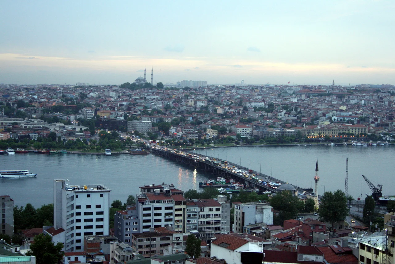

Atatürk Bridge
Sultan Mahmud II crossed the first bridge here on horseback in 1836. The bridge he rode over was an Ottoman bascule design — a drawbridge built to let tall-masted ships pass through the Golden Horn — and it was called the Hayratiye Bridge. What stands at Unkapanı today is the fourth crossing to occupy the same site, a 477-meter pontoon bridge completed in 1940 and renamed for the founder of the Turkish Republic. Four bridges in under 200 years, each reflecting the city that built it.
The Reformist Sultan's Bridge
Mahmud II was one of the Ottoman Empire's most consequential reformers, a sultan who dismantled the Janissaries, introduced Western-style military training, and pushed the empire toward modernization with considerable force. His commissioning of the Hayratiye Bridge in the 1830s fit that pattern: the crossing was a practical infrastructure project, supervised by Ahmed Fevzi Pasha, the Deputy Admiral of the Ottoman Fleet, and completed in 1836.
The original bridge was about 400 meters long and 10 meters wide. It connected Unkapanı on the western shore of the Golden Horn with Azapkapı on the eastern side, linking what are now the Fatih and Beyoğlu districts. Built as a bascule bridge — a design that allows one or more spans to rise and let large vessels through — it accommodated the busy maritime traffic that moved through the Golden Horn in the mid-nineteenth century. Mahmud II attended the opening in person, crossing it on his horse.
Iron, Then Another Bridge
The original wooden structure lasted nearly forty years. In 1875 it was replaced by an iron bridge, 480 meters long and 18 meters wide, built by a French company for 135,000 Ottoman gold liras. That second bridge remained in service until 1912, when it was demolished.
The replacement that arrived in 1912 was not purpose-built for this site. The nearby Third Galata Bridge — which had been serving the main crossing between Galata and Eminönü — was disassembled and moved upriver, reassembled at the Unkapanı site as the third crossing at this location. It served until 1936, when storm damage put it out of commission. Three bridges in a century, each iteration widening and extending the infrastructure across the Horn.
The Current Span
Construction of the fourth and current bridge began in 1936 and was completed in 1940. By then the republic founded by Mustafa Kemal Atatürk was 17 years old, and the bridge was renamed in his honor — Atatürk Köprüsü, the Atatürk Bridge. It is also known as the Unkapanı Bridge, after the district on its western shore, a name that persists in everyday usage alongside the official one.
The current bridge is 477 meters long and 25 meters wide. It carries road traffic across the Golden Horn at a point roughly 2 kilometers west of the more famous Galata Bridge. Less visited by tourists, it is a working crossing — buses, cars, motorcycles — embedded in the daily movement of a city of millions. Its proportions are functional rather than decorative.
The Golden Horn It Crosses
The Golden Horn — Haliç in Turkish — is a natural harbor, an estuary of the Bosphorus that cuts into the European side of Istanbul and historically sheltered the Byzantine and Ottoman fleets. Its name comes from the golden color of the water at certain angles of evening light. For centuries it was the most strategically significant body of water in the city.
By the twentieth century the Golden Horn had become heavily industrialized and polluted; a decades-long cleanup effort, beginning seriously in the 1980s, gradually restored its water quality. The bridge crossings above it — of which the Atatürk Bridge is one of several — have witnessed those changes from a fixed vantage point. Traffic crossing to Beyoğlu today passes above water that is meaningfully cleaner than it was a generation ago.
A Tram Extension and Continuing Use
In 2022, the area around the Unkapanı approach to the bridge was comprehensively remodeled to accommodate an extension of Istanbul's T5 tram line. The line had previously run from Alibeyköy; the extension stretched it south through Cibali to Eminönü, changing the street-level geography of the bridge's western access. The work was part of Istanbul's ongoing investment in surface transit infrastructure.
The Atatürk Bridge continues to carry substantial daily traffic. It does not draw visitors the way the Galata Bridge does — no fishermen line its railings, no restaurants fill its lower deck. It is simply a bridge, one that has occupied its site longer than most Istanbul institutions, watching the Golden Horn below change across the centuries while the city above it accelerated beyond anything Mahmud II could have imagined when he rode across the first Hayratiye Bridge in 1836.
From the Air
The Atatürk Bridge crosses the Golden Horn at approximately 41.024°N, 28.965°E, connecting the Unkapanı area of Fatih district on the west with the Azapkapı area of Beyoğlu on the east. From the air at 2,000–5,000 feet, the Golden Horn is a clearly visible estuary cutting into the European side of Istanbul, with the historic peninsula — Hagia Sophia, the Blue Mosque, Topkapı Palace — to the southeast. The bridge is the second-westernmost road crossing of the Golden Horn; the Galata Bridge is approximately 1.5 km to the east, and the Haliç (Golden Horn) Metro Bridge is further east still. The nearest major airport is Istanbul Airport (LTFM), approximately 20 km to the northwest. At lower altitudes the bridge's single-level, concrete span is easily distinguishable from the multi-deck Galata Bridge.
Nearby Stories
- Kocaeli Peninsula 7.6 km away
- Second Battle of Çatalca 11 km away
- Istanbul's Rural Outskirts 14 km away
- MV Struma 20 km away
- HMAS AE2 36 km away
- Bursa 66 km away
- Sangarius Bridge 71 km away
- Januarius MacGahan 101 km away