Battle of Tarakan (1942)
By 10 p.m. on January 10, 1942, a hundred thousand tons of oil were burning. Lieutenant Colonel Simon de Waal had given the order hours earlier, after a Dutch Dornier Do 24 flying boat spotted the Japanese invasion fleet bearing down on Tarakan. Engineer platoons dynamited the drilling pipes, triggering underground explosions that sealed the wells. The refineries went next. A column of fire rose from the tiny island off northeastern Borneo, visible for miles across the Makassar Strait. The Japanese were coming for Tarakan's oil. De Waal intended to make sure they found nothing but ash.
Seven Hundred Wells on a Swamp
Tarakan was an improbable prize. Only 25 square miles in area, the island was mostly hills and coastal swamp, three degrees north of the equator, lashed by tropical heat and humidity. But oil had been discovered at unusually shallow depths, 50 to 300 meters below the surface, and by the early 1940s the Bataafse Petroleum Maatschappij had drilled roughly 700 wells on the island's western side at Pamoesian. A second drilling site operated at Djoeata to the north. The oil sustained everything: the economy, the population, the reason anyone beyond the local inhabitants paid attention to this speck of land in the Netherlands East Indies. Roads connected the drilling sites to the port at Lingkas and little else. Most of Tarakan's interior remained jungle. Japan's war planners, surveying the Dutch East Indies for the resources their empire needed, marked Tarakan as an early objective.
Pillboxes and Minefields
The Dutch knew Tarakan could not hold indefinitely. Their plans called for defending the oil fields as long as possible, then destroying what they could not keep and withdrawing to mainland Borneo. The garrison arranged its defenses around the port complex at Lingkas, with several "fronts" of double-fence barriers guarding approaches from the north, east, and along the waterfront. Concrete pillboxes housed 25-man detachments supported by machine guns, but there were never enough troops to occupy every position simultaneously. The airfield was too small for fighters and bombers alike, limiting aerial defense to anti-aircraft guns that were soon relocated to coastal batteries. The Royal Netherlands Navy laid extensive minefields at the harbor approaches, with the minelayer Prins van Oranje standing ready to block remaining sea lanes. Despite these preparations, a sense of fatalism had already settled over the defenders. Pearl Harbor had been attacked a month earlier, and the Japanese seemed unstoppable.
Landing by Firelight
The Japanese planned a two-pronged assault from Tarakan's eastern shore. Colonel Yamamoto's Right Wing Unit would land near the Amal River and drive west to seize the Pamoesian oilfields, while Major Kanauji's Left Wing Unit would come ashore further south at Tanjung Batu to capture the coastal gun batteries. At 3 a.m. on January 11, Sergeant-Major Spangenberg, commanding 53 troops at the Amal River support point, reported landing vessels approaching through the darkness. The Japanese waded ashore beneath the silhouette of blazing oil fields. Yamamoto's force, confused by the fires, landed four to six kilometers north of their intended beach, mistaking the Gunung Cangkol oil field fires for those of Lingkas. Spangenberg's position became the anchor of the Dutch eastern defense. Under Captain Saraber, retreating troops rallied there, assembling a line of roughly 650 men. But the line was fragile: Javanese machine gunners had received little training, their weapons malfunctioned, and ammunition was almost nonexistent.
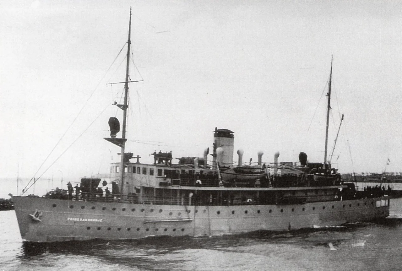
The Minesweepers That Never Returned
While the infantry fought in the jungle, the most dramatic action unfolded at sea. On January 12, six Japanese minesweepers entered the Mengacu Channel to clear the port approaches, ignoring General Sakaguchi's warning. Dutch coastal batteries at Karoengan opened fire with devastating accuracy. Shells struck W-14's bridge, midships, and stern in rapid succession before hitting the ship's depth charges, which detonated in a catastrophic explosion that tore the vessel apart near the mizzenmast. Still firing its one remaining gun, W-14 steamed at full speed toward the battery before striking a mine near Cape Mengacu and sinking bow-first at 12:05. The Karoengan battery then redirected fire onto W-13, which appeared to have lost rudder control and was circling helplessly toward Lingkas. Shells destroyed its bridge and remaining armament, and fires consumed the ship. W-13 went down at 12:15. Of the 200 Japanese naval personnel killed at sea during the battle, 156 died aboard these two minesweepers.
Surrender and Its Aftermath
Lieutenant Colonel de Waal surrendered on January 12. Kanauji's Left Wing Unit, lost in dense jungle where it had managed only 100 meters per hour, did not even seize its objective, the Karoengan battery, until January 13, a day after the fighting ended. That night, the Prins van Oranje attempted to escape eastward but was spotted by the destroyer Yamakaze. In a one-sided engagement at 1,800 meters, every Japanese salvo struck the Dutch minelayer. Around 300 Dutch soldiers died in the battle, and 871 were captured. The Japanese lost 258 killed, mostly at sea. The occupation that followed lasted over three years. By June 1942, Japanese engineers had repaired the sabotaged wells and resumed oil production. Postwar investigations uncovered disturbing accounts: survivors from the sunken minesweepers may have executed Dutch prisoners, beheading some and binding others before throwing them into swamps. The full truth of what happened to the captives was never established. Tarakan remained under Japanese control until May 1945, when Australian troops landed to liberate the island in a battle that proved as costly and controversial as the one that had lost it.
From the Air
Coordinates: 3.35N, 117.57E. Tarakan Island lies just off the northeast coast of Borneo (Kalimantan), Indonesia. Juwata International Airport (WALR) serves the island today. The Makassar Strait is visible to the east. From altitude, Tarakan's triangular shape and coastal swamps are clearly defined. The oil infrastructure at Pamoesian, on the island's western side, and the port at Lingkas remain identifiable. Balikpapan's Sultan Aji Muhammad Sulaiman Airport (WALL) is the nearest major hub, approximately 300 km to the south.
Nearby Stories
- Borneo's River of Names 29 km away
- Sebatik Island 55 km away
- Sipadan 73 km away
- Ambalat 91 km away
- Kakaban 122 km away
- Maliau Basin 128 km away
- Martin B-10 145 km away
- The Secret War in Borneo's Jungle 168 km away