Bundesautobahn 30
For most of its life, the Bundesautobahn 30 had a hole in it. From the Dutch border at Bad Bentheim it ran cleanly east, past Rheine and Osnabrück, all the way toward Bad Oeynhausen - and then, just before connecting to the A2 toward Berlin, it simply stopped. Traffic poured off the motorway onto a local highway and crept through the spa town of Bad Oeynhausen in long sullen queues, often for hours. The gap was barely ten kilometers long. Closing it took eighty-five years.
Eighty-Five Years of Planning
The first plans for a German-Dutch motorway were drawn up in 1933. The proposed route ran from Oldenzaal across the border through Bad Bentheim, Salzbergen, and Rheine. By 1938-40, German planners had refined it: south of Salzbergen, north of Rheine, south of Osnabrück, meeting the A2 near Herford and Bielefeld. War interrupted everything. Postwar Germany kept the rough alignment but quietly shelved the eastern extension to Hannover - all that remains of those abandoned plans are some odd-looking bypasses around Stadthagen and Minden, and a phantom interchange near Laatzen that goes nowhere. Had the original Hannover extension been built, the segment near Bad Oeynhausen would have carried the number A339 instead. Engineering happens in alternate universes too.
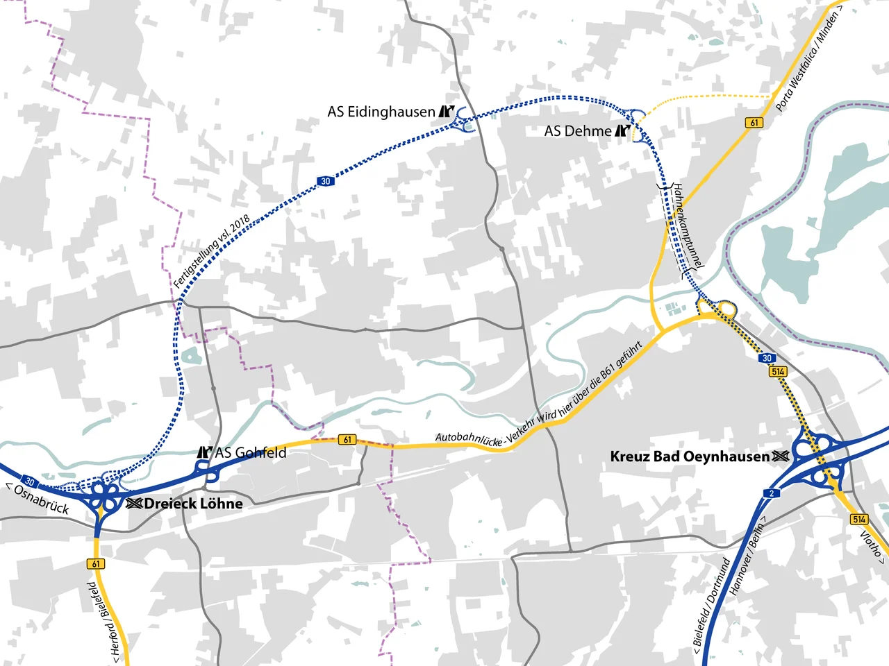
The Last Ten Kilometers
By the 1990s, the A30 was a vital artery of European Route E30, the Amsterdam-Berlin axis carrying tens of thousands of freight movements a week. Every single one of them, in the eastbound direction, eventually fed into the same local detour through Bad Oeynhausen. The town's residents lived with the noise, the diesel exhaust, and the chronic traffic jams of a highway running through their main street. Plans for a proper northern bypass existed - had existed for decades - but disputes over the exact route, the environmental impact, and the wishes of a determined citizens' group kept the project frozen. The government of the Detmold region finally issued a planning decision in January 2007: a 10-kilometer section with two new exits, twenty-eight bridges, and a tunnel.
The Citizens Who Said No
The citizens' group opposing the highway did not roll over. They filed a complaint with the Federal Administrative Court and applied for emergency legal protection - a kind of injunction meant to stop construction before it began. In July 2008, the court rejected them. Construction began that autumn. For ten years, drilling rigs and concrete trucks reshaped the landscape just north of Bad Oeynhausen, threading the new motorway around the spa town and over the Werre valley. The tunnel went in. The twenty-eight bridges were stitched together. On 9 December 2018, the new section of the A30 opened to traffic and the last bottleneck on the Amsterdam-Berlin corridor finally closed - eighty-five years after the original 1933 plan.
What the Road Connects
Today the A30 begins at the Dutch border between Nordhorn and Bad Bentheim, where it picks up the Dutch A1 from Amsterdam without missing a beat. Heading east, it crosses the A31 near Schüttorf, offering southbound drivers a clean run to the Ruhr area and northbound traffic a route to Emden on the North Sea. Past Rheine, the road meets the great north-south spine of the A1 near Osnabrück, intersects with the A33 toward Bielefeld and Paderborn, and finally arrives at the A2 near Bad Oeynhausen. From there, eastbound traffic continues toward Hannover and Berlin, while northbound traffic flows toward Bremen and Hamburg. The corridor stitches the Netherlands to the Polish border without ever leaving the broad flat plain of northwestern Germany.
From the Air
The A30 runs roughly along 52.2°N from approximately 7.0°E (Dutch border at Bad Bentheim) to 8.8°E (Bad Oeynhausen / A2 interchange). From the air, the corridor is a clear east-west line across the otherwise rural North German plain, parallel to the Mittellandkanal which runs slightly north. Münster Osnabrück Airport (ICAO: EDDG) is the closest major airport, situated just south of the route near Greven. The Wiehen Hills rise to the south near Osnabrück, providing visual orientation. Total length is approximately 140 km from Dutch border to A2.
Nearby Stories
- Ibbenbüren 2.3 km away
- Münster-Handorf Airfield 4 km away
- Diepholz 9.2 km away
- RAF Gütersloh 12 km away
- Emsland Railway 31 km away
- Gardelegen Massacre 181 km away
- Ludwigslust Palace 200 km away
- Memleben Abbey 205 km away