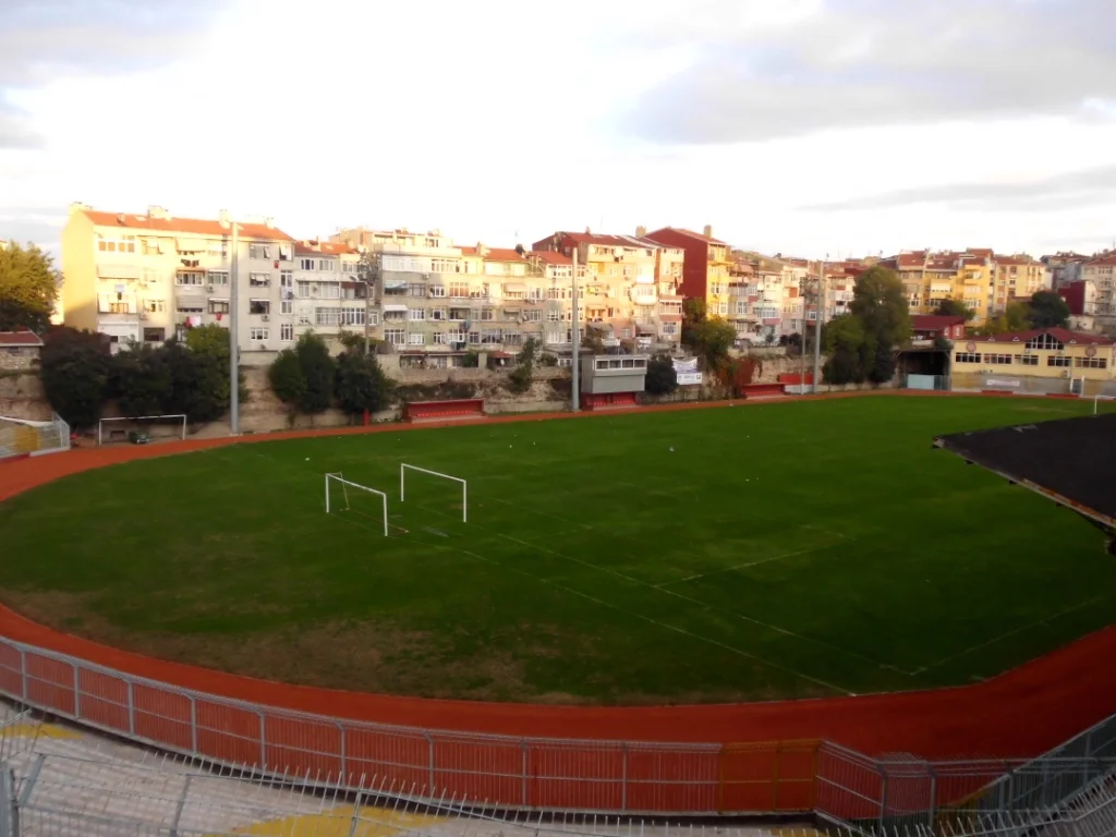

Cistern of Aetius
The football pitch at Karagümrük is not a normal sports ground. It sits in a rectangle that was already old when the Ottoman Empire was young — a sunken basin near the old Theodosian walls where Byzantine engineers cut stone and poured water in the 5th century CE. The crowd that watches matches here from the surrounding embankments is, without necessarily knowing it, sitting on the walls of one of the largest water reservoirs the ancient world built in this city.
Water for a Capital
Constantinople in the 5th century faced a problem that every growing imperial capital eventually confronts: its population was outpacing its water supply. The city already had the underground Basilica Cistern and a network of subterranean reservoirs, but open-air cisterns offered far greater capacity. The Cistern of Aetius — named after Aetius, the city prefect (praefectus urbi) of Constantinople who oversaw its construction in 421 CE — was carved into the valley between the fifth and sixth hills of the city. Its position mattered. By sitting at the upper end of a natural valley along what is now Fevzi Paşa Caddesi, not far southeast of the Byzantine Gate of Charisius (later called the Gate of Adrianople, now the Gate of Edirne), the cistern could gravity-feed water downhill into the denser inhabited areas of the city. Whether it was also intended to supply the city's defensive moat remains debated — scholars consider it more likely that it served as a central distribution reservoir.
The Hollow Garden
After the Ottoman conquest of Constantinople in 1453, the city changed faster than most of its infrastructure. The great cisterns, no longer maintained by Byzantine engineers, gradually silted up and fell out of use as water systems. By the early Ottoman period, the Cistern of Aetius was known as Çukurbostan — "hollow garden" — and that is exactly what it had become: the deep rectangular basin, with its walls still standing and its floor exposed to sunlight, made a natural sunken plot for growing vegetables. Farmers worked the bottom of what had been a Roman reservoir, the walls acting as a windbreak and the depth creating a microclimate slightly warmer and more sheltered than the surrounding city. The name Çukurbostan was the Ottoman population's entirely pragmatic description of what they found: a useful hollow in the ground.
A Stadium in the Walls
Since 1928 the site has functioned as a football ground. Fatih Karagümrük SK, one of Istanbul's older clubs, plays here, and the stadium that occupies the cistern floor takes advantage of the same geometry that made the basin useful for vegetables: the rectangular depression provides a natural bowl, with spectators sitting on the embankments and original Roman walls. The current stadium — known as the Karagümrük Stadyumu (or Vefa Stadyumu) — replaced the Ottoman name in the Republican era. The walls of the original cistern, built using the Roman opus listatum technique alternating courses of brick and stone, are still partially visible around the perimeter. They have survived fifteen hundred years of Constantinopolitan and Ottoman and Turkish history with enough structural integrity to hold a crowd.
A Valley Between Two Hills
The Fatih district, where the cistern sits, is one of Istanbul's most historically dense neighbourhoods — part of the old walled city, where the street plan still reflects Byzantine and Ottoman layers more than modern planning. Walk along Fevzi Paşa Caddesi and the ground rises and falls in ways that remind you this is a genuinely hilly city, built on seven hills the way Rome claimed to be built on seven hills. The Cistern of Aetius occupies the upper end of the valley that separates the fifth and sixth of those hills. It is not a tourist site in any formal sense; there is no museum, no interpretive panel, no admission charge. It is a place where people watch football in a 5th-century bowl, and where the most remarkable thing — the antiquity of what you are standing in — is also the thing least remarked upon.
From the Air
The Cistern of Aetius lies at approximately 41.0278°N, 28.9392°E in the Karagümrük neighbourhood of the Fatih district, within Istanbul's historic walled city on the European shore. From the air at 2,500 feet, the site appears as a distinct rectangular depression in the urban fabric, clearly visible against the surrounding street grid, located about 300 meters southeast of the line of the old Theodosian Walls near the Gate of Edirne. The Bosphorus is visible approximately 5 km to the east; the Golden Horn waterway lies about 2 km to the north. The nearest airport is Istanbul Airport (LTFM) approximately 40 km to the northwest.
Nearby Stories
- Kocaeli Peninsula 7.6 km away
- Second Battle of Çatalca 11 km away
- Istanbul's Rural Outskirts 14 km away
- MV Struma 20 km away
- HMAS AE2 36 km away
- Bursa 66 km away
- Sangarius Bridge 71 km away
- Januarius MacGahan 101 km away