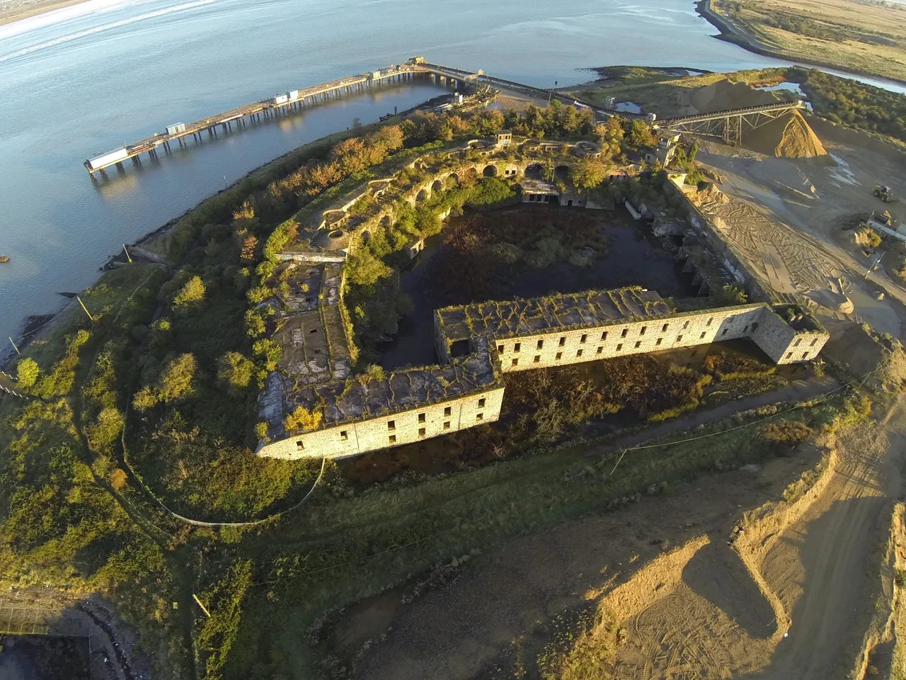

Cliffe Fort
The fort started cracking in 1865, four years into a planned construction that would take another five. The soft marsh ground at the entrance to Cliffe Creek - chosen because it commanded the Thames, ignored when it came to bearing the weight of granite-faced casemates - was subsiding under the half-built structure. The original plan had called for thirteen guns on the roof. Those plans were quietly dropped. The engineers thickened the concrete bed from seven feet to fourteen, drove thirty-foot piles into the silt, and accepted that whatever they built here was going to settle into the marsh whether they wanted it to or not. They were correct. Cliffe Fort has been slowly settling for over 150 years.
The Arms Race That Built It
By the late 1850s, Britain and France were locked in an arms race that nobody alive today particularly remembers. France had launched La Gloire, the first ocean-going ironclad warship. Britain had responded with HMS Warrior. A new generation of rifled guns - both muzzle-loading and breech-loading - could pierce armour at ranges that older smooth-bore cannon could only dream of. Britain's coastal defences had not been substantially upgraded since the Napoleonic Wars. A Royal Commission was appointed, reported in 1860, and recommended a chain of new forts along the south coast - the so-called Palmerston Forts, named for the Prime Minister who pushed them through Parliament. On the lower Thames, east of Gravesend, the Commission called for a triangle: a new Coalhouse Fort on the Essex shore, a rebuilt Shornemead Fort, and an entirely new fort at Cliffe on the Kent side. The three forts would create interlocking fields of fire across the river, against ships that would soon become obsolete in another way.
Building on a Marsh
Construction began in 1861. The estimated cost was around £163,000 - a substantial sum, though only a fraction of what would actually be spent. The original plan was ambitious: thirteen guns on the roof, three more mounted en barbette behind a parapet, two for land defence at the rear, and another twenty guns below in granite-faced casemates fitted with iron shields to protect the crews. Three caponiers - small projecting structures with firing loops - would defend the approaches. Then the marsh started winning. The fort began subsiding and cracking in 1865. The roof-mounted guns were abandoned. The design was altered to a purely casemated fort, very similar in plan to Coalhouse Fort being built across the river. The fort was finally completed in 1870, nine years after work began, with an arsenal that included two 12.5-inch and nine 11-inch rifled muzzle-loaders mounted in casemates plus two 9-inch guns in the open battery upriver. By the time it was finished, Cliffe Fort was already obsolescent for its original purpose. Naval gunnery had moved on. So had naval threats.
The Brennan Torpedo
In 1890 the fort acquired something genuinely novel. Louis Brennan, an Irish-born inventor working in Australia, had developed a wire-guided torpedo - a self-propelled underwater weapon that operators on shore could steer mid-flight by adjusting the speeds at which two unwinding wires were drawn from spools inside the torpedo. The Brennan torpedo has been described as the world's first practical guided missile, predating any other operational guided weapon by decades. Cliffe Fort was equipped with a Brennan torpedo station: a slipway down to the water, an engine room converted from one of the magazines, ancillary chambers for the winding gear, and a magazine for the torpedoes themselves. The system was sophisticated for its day. It was also expensive, slow to deploy and quickly overtaken by self-propelled torpedoes that did not need wire guidance. The Brennan station at Cliffe was only in active use for a few years. By the early 20th century it had been dismantled. Today the remains of the slipway can still be made out at the river's edge, though the other was infilled long ago.
Two World Wars and Out
In the First World War the fort's older guns were replaced by two 6-inch breech-loading Mk VII guns on the roof, then by four quick-firing guns near the end of the war. By 1927 the fort was disarmed altogether. Then came World War II, and Cliffe was repurposed once more - this time as an anti-aircraft battery, with two 4-inch guns mounted on the roof positions to defend the eastern approaches to London. It served as a base for the Royal Navy Auxiliary Service. Aircraft passed overhead. Bombs fell on the dockyards downstream. The fort's last military role lasted only as long as the war did. After 1945 it was surplus to requirements - a Victorian artillery fort in an age that no longer needed Victorian artillery forts, sitting on marshy ground that had defeated its builders and would now slowly reclaim it.
The Slow Return to the Marsh
The War Office sold Cliffe Fort in the 1950s or 1960s to the owners of the large aggregates works that had grown up next to it. For a while it was the headquarters of the Blue Circle Sailing Club. Then it was abandoned. Today the fort is derelict, overgrown, heavily flooded inside, and listed on the Heritage at Risk register. The interior is structurally sound but inaccessible to the public - the building still sits on private industrial land. The Saxon Shore Way, a long-distance footpath following what was once the Roman shore defence line of southeast England, runs past the fort's exterior, and walkers can see the bulk of it rising out of the marsh on the river side. The casemates are flooded. The granite still faces seaward. The roof where Brennan torpedoes once waited has settled another fraction of an inch since you started reading this. The Thames keeps doing what the Thames does. The marsh keeps doing what marshes do. Eventually the fort and its problems will become a single problem, which the river will solve in its own slow way.
From the Air
Cliffe Fort sits at 51.46°N, 0.46°E on the south bank of the River Thames at the entrance to Cliffe Creek, on the Hoo Peninsula in north Kent. The fort is a distinctive shape from the air: a Victorian artillery fort rising out of marshland next to a large aggregates works, with the river to the north and the marshes of the Hoo Peninsula stretching south. Rochester Airport (EGTO) is 8 miles southwest; London City (EGLC) is 20 miles west. Best viewed from 1,500-3,000 feet over the marshes.
Nearby Stories
- Waltham Abbey Royal Gunpowder Mills 1.6 km away
- Bethlem Royal Hospital 4.4 km away
- Sissinghurst Castle Garden 5.6 km away
- Chelmsford 6.5 km away
- Herne Bay Pier 6.7 km away
- Operation Stack 7.1 km away
- St Osyth's Priory 13 km away
- Plymouth Brethren 24 km away