Damme Hills
Roughly 230,000 years ago, a lobe of the Scandinavian ice sheet ground south through what is now Lower Saxony, met an obstacle, and stopped. As the ice paused, it kept pushing the dirt and rock at its leading edge into a long, sweeping arc - the way a snowplough's blade builds a berm without meaning to. When the ice eventually retreated, that berm remained. Today it is the Damme Hills: a fifteen-kilometre wooded ridge whose highest point, the Signalberg, rises 146 metres above sea level. In a landscape this flat, 146 metres is mountain country.
The Glacier's Signature
Geologists call this kind of feature a push moraine, and the Damme Hills are a textbook example of one. They formed during what is called the Drenthe I stage of the Saale glaciation, in the so-called Rehburg Phase. Their almost mirror-image counterpart is the Ankum Heights twenty kilometres to the west, and together the two ridges sketch the outline of the ice lobe that once filled the lowland bay of the Artland between them. Below the surface lies iron ore - a deep deposit that hints at the much older sedimentary story the glacier merely rearranged. The whole structure sits on the Weser-Ems watershed: rain that falls on the eastern slope flows via the Hunte into the Weser and on to the North Sea at Bremerhaven; rain on the western slope flows via the Hase into the Ems.
A Ridge of Beech and Pine
Walk the ridge today and you walk through patches of beech wood that alternate with planted pine, hayfields, paddocks, and small lakes. The Damme Bergsee, about twenty-five hectares of open water near the centre of the ridge, has its own nature trail and serves as a refuge for plants and animals that have largely been pushed out of the surrounding agricultural country. Of the 364 vascular plants recorded in the area, 68 sit on Lower Saxony's Red List of endangered species. There are five species of woodpecker. The Eurasian woodcock, common crossbill, and pied flycatcher all breed here. Three of Germany's largest native beetles - the stag beetle, the rhinoceros beetle, and the cockchafer - hide in the rotting wood. Four species of reptile share the leaf litter: the grass snake, sand lizard, viviparous lizard, and slowworm. In 1974 even European rollers tried to breed in the woods, though they were shot by a farmer before they finished.
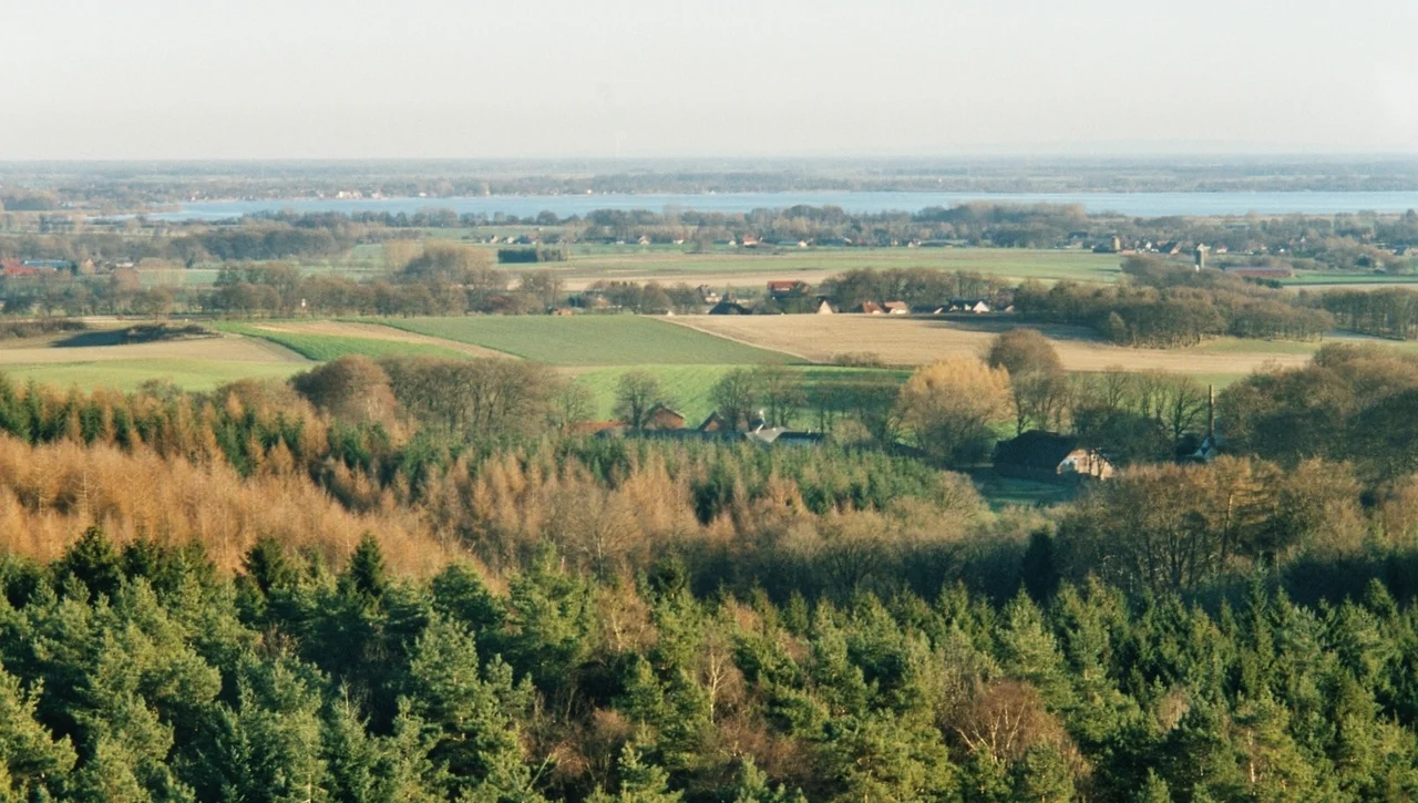
Towers and Views
The two principal lookouts are the Steigenberg in the southwest and the Mordkuhlenberg toward the north. From the platform on the Mordkuhlenberg - 142 metres up and crowned with a wooden observation tower - the view opens across the whole ridge. To the east you can see the broad pale sheet of the Dümmer, with the Stemweder Berg low behind it. South lie the Wiehen Hills, the ridge that lifts the horizon along the northern edge of the Teutoburg Forest country. North and west you can see the flat green tile-pattern of the Oldenburg Münsterland fading toward the horizon. The Signalberg, the highest point and the one closest to the town of Damme, is less of a destination because it is occupied: a Bundeswehr transmitter mast stands on top, and a 134-metre Deutsche Telekom telecommunication tower rises on its northern slope. The hill that is the highest is the one you cannot quite climb.
Quiet, Used Country
The Damme Hills sit inside the Dümmer Nature Park, which spreads outward to include the lake, the wide raised bogs of the Großes Moor, and the Stemweder Berg. There are bike trails and footpaths that loop the ridge in every direction. The towns at its feet - Damme in the centre, Steinfeld and Lohne to the north, Holdorf to the northwest, Diepholz further east, Neuenkirchen-Vörden to the southwest - are working agricultural communities of a few thousand people each, the kind of places where a Sunday hike in the hills is a normal afternoon. The ridge is the Oldenburg Münsterland's local mountain in a region that has no other. That is enough.
From the Air
The Damme Hills run at roughly 52.55 degrees N, 8.22 degrees E, forming a 15-km north-northeast-trending wooded ridge in the southern Oldenburg Münsterland of Lower Saxony, about 34 km north of Osnabrück. From altitude the ridge reads as a clear dark green spine in an otherwise flat agricultural landscape, with the broad pale sheet of the Dümmer lake immediately to the east and the patchwork of the Großes Moor to the south. The 134-metre Deutsche Telekom tower on the Signalberg is a useful visual marker. Nearest airport is Münster Osnabrück International (EDDG), about 50 km south-southwest. Best viewing altitude 3,000-6,000 feet in clear weather.
Nearby Stories
- Else (Werre) 0.6 km away
- Münster Osnabrück Airport 8.7 km away
- Visbek 12 km away
- Ibbenbüren 22 km away
- Börger 24 km away
- Gardelegen Massacre 178 km away
- Ludwigslust Palace 192 km away
- Memleben Abbey 214 km away