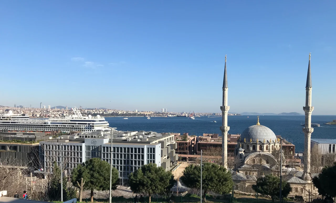

Galataport
For most of the twentieth century, the stretch of waterfront between the Karaköy ferry terminal and the Tophane district was a place of purposeful neglect — warehouses stripped of their original function, an old customs building going slowly to seed, a string of nargile cafes filling the void where commerce had once been. The Istanbul Modern art gallery occupied one of the old warehouse shells, which told you something about what the neighborhood had become: a place awaiting reinvention. Galataport is that reinvention. A 400,000 square-meter mixed-use development along 1,200 meters of Bosphorus shoreline, backed by over US$1.8 billion invested by Turkey's Doğuş Group and Bilgili Holding, it opened in stages through 2022 and transformed a forgotten industrial edge into one of the most visited stretches of waterfront in Europe.
The Port Beneath the Port
The engineering challenge at the heart of Galataport is not visible from the promenade. The cruise terminal — which spreads across 29,000 square meters and handles up to three large ships simultaneously — is almost entirely underground. Customs and immigration facilities, passenger processing halls, and supporting infrastructure were tunneled beneath the waterfront to leave the surface open to the public. It is a significant piece of logistics work. Ships dock at specially designed screens that rise when vessels are in port and retract when they are not, maintaining a clean sightline along the shore. The effect, for a visitor walking the promenade, is that the port is there and then suddenly not there — a working cruise terminal with the presence of a public park. The Bosphorus glitters across the water to the historic peninsula, with Topkapı Palace and Hagia Sophia framed in the distance.
A Square Built Around a Clock Tower
Behind the waterfront promenade, Galataport created a new public square on the site of what was once a military parade ground. The square's organizing element is Istanbul's first freestanding clocktower, which now stands at the center of a space large enough to host concerts and outdoor events. The architecture surrounding the square reads like a compressed inventory of Istanbul's past several centuries: the Nusretiye Mosque from the 1820s on the west side; the Tophane Pavilion, designed by William James Smith in 1852 as a viewing base for the sultan; the Kılıç Ali Paşa Mosque designed by Mimar Sinan in the sixteenth century on the south side; and the Tophane Fountain from 1732. New buildings anchor the water side, including Renzo Piano's purpose-built home for the Istanbul Modern art museum, which opened on the square following the project's completion.
Heritage Buildings Given New Purpose
The Paket Postanesi — the old parcel post office, designed by S. Saboureaux and opened in 1911 — has become one of Galataport's signature landmarks, restored and converted to house shops and exhibition space. It stands as the most architecturally distinctive building in the complex, its elaborate facade now cleaned and lit rather than crumbling. The old Customs Building (Gümrük Binası), dating to 1895 and lavishly decorated with tilework, is still being renovated and finding new uses. In total, the shopping and dining complex spans 52,000 square meters across the restored historic structures and new construction, with 250 shops, restaurants, and food outlets. The Peninsula hotel group operates within the complex. Forty-three thousand square meters of office space and parking for 2,400 cars are integrated into the development.
The City It Is Changing
Galataport's impact does not stop at its own edges. The neighborhoods immediately adjacent — Karaköy and Tophane — were already shifting before the port opened, as new hotels appeared and short-term rental apartments multiplied in anticipation of increased tourist traffic. The transformation accelerated once the terminal began operating. Shops and restaurants that once catered primarily to locals have adjusted their offerings for visitors arriving by the shipload. Whether this is renewal or displacement depends on where you stand and whether you are a long-term resident or a new arrival. The development's proponents point to the restoration of derelict buildings and the creation of genuine public space; its critics note that the neighborhoods surrounding it are becoming more expensive and less local. Istanbul has been navigating this tension for decades, and Galataport is its current sharpest edge.
The View From the Water
Istanbul has always been best understood from the sea. The city's defining silhouette — domes, minarets, the hillsides of the old city climbing away from the water — is a view designed, over centuries, to be seen from ships approaching through the Bosphorus or the Sea of Marmara. Galataport adds a new layer to that view: a modern waterfront that does not pretend the old Ottoman shore was sufficient for contemporary use, but that has tried, with considerable investment, to honor what was already there. Standing at the promenade's edge with the historic peninsula across the water and the Galata Tower rising above on the hill behind, you can trace the conversation between old Istanbul and new — a conversation this city has been having with itself since Constantine planted his capital here in 330 CE.
From the Air
Galataport occupies the Bosphorus waterfront at approximately 41.025°N, 28.981°E in the Karaköy and Tophane districts of Istanbul's European side. From the air, the development is immediately identifiable as the modern waterfront complex on the western shore of the Bosphorus strait, just south of where the Golden Horn meets the strait. The Galata Bridge is visible to the south, and the Galata Tower — a medieval stone cylinder — rises above the hill immediately to the northwest. At 3,000 feet, the full 1,200-meter length of the developed shoreline is visible, along with the contrast between the historic peninsula's skyline across the water and the renovated waterfront below. The nearest major airport is Istanbul Airport (LTFM), approximately 32 kilometers to the northwest. Approach from the north offers the clearest aerial view of the full Galataport development.
Nearby Stories
- Kocaeli Peninsula 7.6 km away
- Second Battle of Çatalca 11 km away
- Istanbul's Rural Outskirts 14 km away
- MV Struma 20 km away
- HMAS AE2 36 km away
- Bursa 66 km away
- Sangarius Bridge 71 km away
- Januarius MacGahan 101 km away