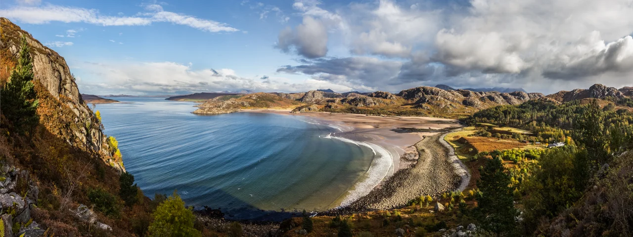

Gruinard Bay
The sand at Mellon Udrigle, on the west side of Gruinard Bay, is the colour of old roses. It is one of the strangest beaches in Britain - pink quartz and feldspar washed down from the Lewisian gneiss of the surrounding hills, ground fine by the Atlantic, deposited on a curve of coast that almost no one outside Wester Ross has heard of. A few miles offshore sits Gruinard Island, the small uninhabited landmass that for 48 years was the most dangerous square mile in Britain. The bay around it is shaped like the letter L. The water is some of the clearest in the Highlands. On a still summer evening, the seals haul out on the skerries and you can hear them breathing.
The Shape of the Coast
Gruinard Bay sits twelve miles north of the village of Poolewe, on the west coast of Ross and Cromarty. It is hemmed in by water on every side: Loch Broom to the north-east, Little Loch Broom curving in from the east, the open Minch to the west, and Loch Ewe to the south-west. The bay measures 5.5 miles along its western shore and 4.5 along its eastern, joining at a near-right angle around the Rubha Mor peninsula. The settlements cluster on the eastern shore - Little Gruinard at the south-east corner, then the strung-out crofting townships of Sand, First Coast and Second Coast along the south coast, all on the A832 - and on the west, the former fishing village of Laide and the smaller crofting townships of Achgarve, Mellon Udrigle and Opinan. None of these places is large. Most have under a hundred residents.
Three Rivers, One Wilderness
Three fast rivers spill into the bay. The Little Gruinard runs four miles down from Fionn Loch, draining the heart of the Great Wilderness of Dundonnell and Fisherfield. The larger River Gruinard tumbles from Loch na Sealga and Loch Ghiubhsachain, also in the wilderness, and enters the bay at the west end of Camas Gaineamhaich beach. The smaller Inverianvie threads between them, descending from Loch a' Mhadaidh Mor. All three carry the dark peat stain of upland Scotland, and all three hold runs of salmon and sea trout that have been fished for centuries. The Gruinard in particular is one of the most celebrated and tightly held private fishings in the north-west - water that almost no casual angler will ever cast a line in.
The Pink Sand
Mellon Udrigle beach, on the bay's west side, is what most people who travel through here come to see. The sand really is pink, not in some metaphorical or marketing-brochure sense but in the actual mineral sense: granular pink quartz and feldspar in proportions that catch the eye even on a grey day. The water shelves gently. On the rare hot days the bay sees, families wade out into water so clear that the sand pattern on the bottom is sharp at chest depth. Across the bay, the bare hump of Gruinard Island - small, oval, treeless - sits a kilometre or so offshore. The Summer Isles are visible to the north-east in clear weather. Pleasure boats are rare. The fishing fleet that once worked out of Laide is long gone.
The Wartime Anchorage Next Door
Just over the headland to the south sits Loch Ewe, which was one of the most important Royal Navy anchorages of the Second World War. Convoys assembled there for the Arctic run to Murmansk and Archangel, carrying war materiel to the Soviet Union under merciless conditions. Gruinard Bay sat just outside the security perimeter but well inside the strategic interest zone. The Second World War also reshaped the population of Loch Ewe and the islands in it - the families that lived on the Isle of Ewe were largely cleared during the naval requisition. And of course it was in 1942, in the middle of all this, that the most notorious wartime event on this stretch of coast took place: the British government's biological weapons trial on Gruinard Island, just offshore.
What You Pass Over
From the air, Gruinard Bay reads as a clear hinge between the openness of the Minch and the closed land of the interior. The L-shape catches light. The pink stripe of Mellon Udrigle stands out against the bracken-coloured machair behind it. The Summer Isles scatter to the north-east; the broken cliffs of Greenstone Point rise to the south-west; the small oval of Gruinard Island sits in the bay's mouth like an exclamation mark. Three river mouths sit along the eastern shore, their estuaries dark with peat. The A832 traces the south coast. Behind it, almost without transition, the mountains of the Great Wilderness rise into An Teallach and the long ridge of Beinn Dearg Mor.
From the Air
Gruinard Bay lies on the west coast of Wester Ross at 57.88 N, 5.49 W. Inverness Airport (ICAO EGPE) is about 110 km east-south-east; Stornoway (EGPO) about 80 km west across the Minch. Recommended viewing altitude 2,500-4,000 ft AGL - low enough to see the pink sand of Mellon Udrigle and the small oval of Gruinard Island offshore. The Summer Isles to the north-east and An Teallach inland are major landmarks. Watch for sudden weather changes off the Atlantic.
Nearby Stories
- Stoer Head Lighthouse 6.8 km away
- Beinn Eighe 8.7 km away
- Tiumpan Head Lighthouse 13 km away
- South Rona 14 km away
- Battle of Tuiteam Tarbhach 17 km away
- Conon Hydro Scheme 22 km away
- Shiant Islands 23 km away
- Loch Naver 33 km away