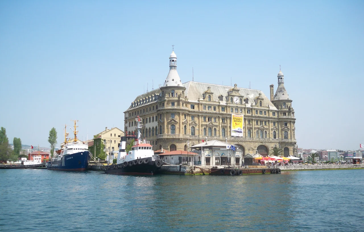

Haydarpaşa
Haydarpaşa is named after an Ottoman vizier called Haydar Pasha, whose connection to the place is now mostly forgotten while his name has been borrowed by nearly everything in it. The district sits on a wedge of Bosphorus waterfront between Harem to the northwest and Kadıköy to the southeast, on Istanbul's Asian shore, and it contains an unusual concentration of large 19th- and early 20th-century public buildings for a neighborhood of its size. There is almost nothing domestic here: no residential streets to speak of, no market quarter. What Haydarpaşa accumulated across the late Ottoman period was institutions — hospitals, schools, a massive railway terminus, a port, a military barracks, a cemetery. The district became, in effect, a campus of empire built on the Asian edge of the city.
The Ottoman Institution-Builders
The buildings of Haydarpaşa were not planned as a coherent whole — they accumulated over several decades of Ottoman modernization, as the empire sought to create infrastructure that matched European standards. The Haydarpaşa railway terminal opened on September 22, 1872, initially running only to Pendik before the line was extended to İzmit in 1873 — the first step in connecting Istanbul to the rail network that would eventually reach Baghdad. The port followed and grew into Istanbul's main container terminal. Around the same time, the district's hospitals were taking shape. The Haydarpaşa Numune Hastanesi and the GATA Military Medical Academy's Haydarpaşa Hospital were built in the same architectural idiom as the railway station — European institutional neoclassicism adapted to Ottoman purposes, in the hands of architects like Alexander Vallaury and Raimondo D'Aronco. These buildings were not incidental to the city; they were intended as signs of modernity, visible from the water as ferries crossed between the European and Asian shores.
A Jewish School and Its Closure
Not everything in Haydarpaşa's history belongs to the grand official narrative. In 1875, a Jewish community school was established in the neighboring Yeldeğirmen area — the École Communale Israélite de Haidar-Pacha, operating in French as Jewish schools throughout the Ottoman Mediterranean commonly did. A new building may have been constructed in 1903. The school served the local Jewish population for decades, with an enrollment that reached around 150 students. Then, after the early Turkish Republic required Jewish schools to choose between Hebrew and Turkish as their primary language of instruction, French education could no longer be offered. Enrollment dropped to around 50, and the school closed in 1935. The wooden portions of the building were later demolished; the brick section survives. It is a small story set against the larger upheavals of early 20th-century Istanbul, but it belongs to the neighborhood's texture: a community that was present, built something, and then found the conditions that had made their institution possible had changed.
Florence Nightingale in the Vicinity
Haydarpaşa's most famous historical connection lies just across its border in the adjacent area of Harem, where the Selimiye Barracks stand. During the Crimean War, those barracks were converted into the military hospital the British called Scutari — and it was there, from November 1854 to July 1856, that Florence Nightingale led her nursing team and transformed the management of military medicine. The Selimiye Barracks are technically in Harem rather than Haydarpaşa proper, but the two areas merge at their boundary, and the British war cemetery on Haydarpaşa's hillside holds the graves of many who died in that hospital before Nightingale could change the conditions sufficiently to save them. The proximity is not incidental: Haydarpaşa was where the ships docked, where the trains departed, where the port handled supplies. The district was the logistical interface between the hospital above and the sea routes below.
The Shore That Still Waits
Today Haydarpaşa carries its history lightly. The railway station is closed, under a long restoration, its future as a combined terminus and museum still being negotiated. The port handles container traffic. The hospitals continue operating. Marmara University's Faculty of Medicine occupies a building that served as Haydarpaşa High School from 1933 to 1983 — another layer of institutional use in a district where almost no building has ever had just one purpose. Ferries still connect Haydarpaşa to Eminönü, Karaköy, and Kadıköy on the other shore, as they have for generations. The Bosphorus still passes the waterfront, carrying ships between the Black Sea and the Sea of Marmara, as it has for millennia before Haydar Pasha or any of his monuments existed. What the district offers a visitor is density: within a few hundred meters, five or six large buildings that each carry a substantial piece of Istanbul's modern history, set against a waterfront that has always been a place of departure and arrival.
From the Air
Haydarpaşa district is centered at approximately 41.00°N, 29.017°E on Istanbul's Asian (Anatolian) shore, immediately south of the Bosphorus crossing point. The nearest airport is Sabiha Gökçen International (LTFJ), approximately 25 km to the southeast. From the air at 1,500–2,000 feet, the district is one of the most architecturally identifiable zones on the Asian shoreline: the twin towers of Haydarpaşa railway station mark the southern end, the container terminal and port infrastructure extend to the north, and the large rectangular footprint of the Selimiye Barracks is visible in the adjacent Harem area to the northwest. The hillside cemetery with its ordered rows of white Commonwealth war graves is visible on the slope between the hospital complex and the port. The European shore with Topkapi Palace, Hagia Sophia, and the Blue Mosque is clearly visible across the Bosphorus to the west.
Nearby Stories
- Kocaeli Peninsula 7.6 km away
- Second Battle of Çatalca 11 km away
- Istanbul's Rural Outskirts 14 km away
- MV Struma 20 km away
- HMAS AE2 36 km away
- Bursa 66 km away
- Sangarius Bridge 71 km away
- Januarius MacGahan 101 km away