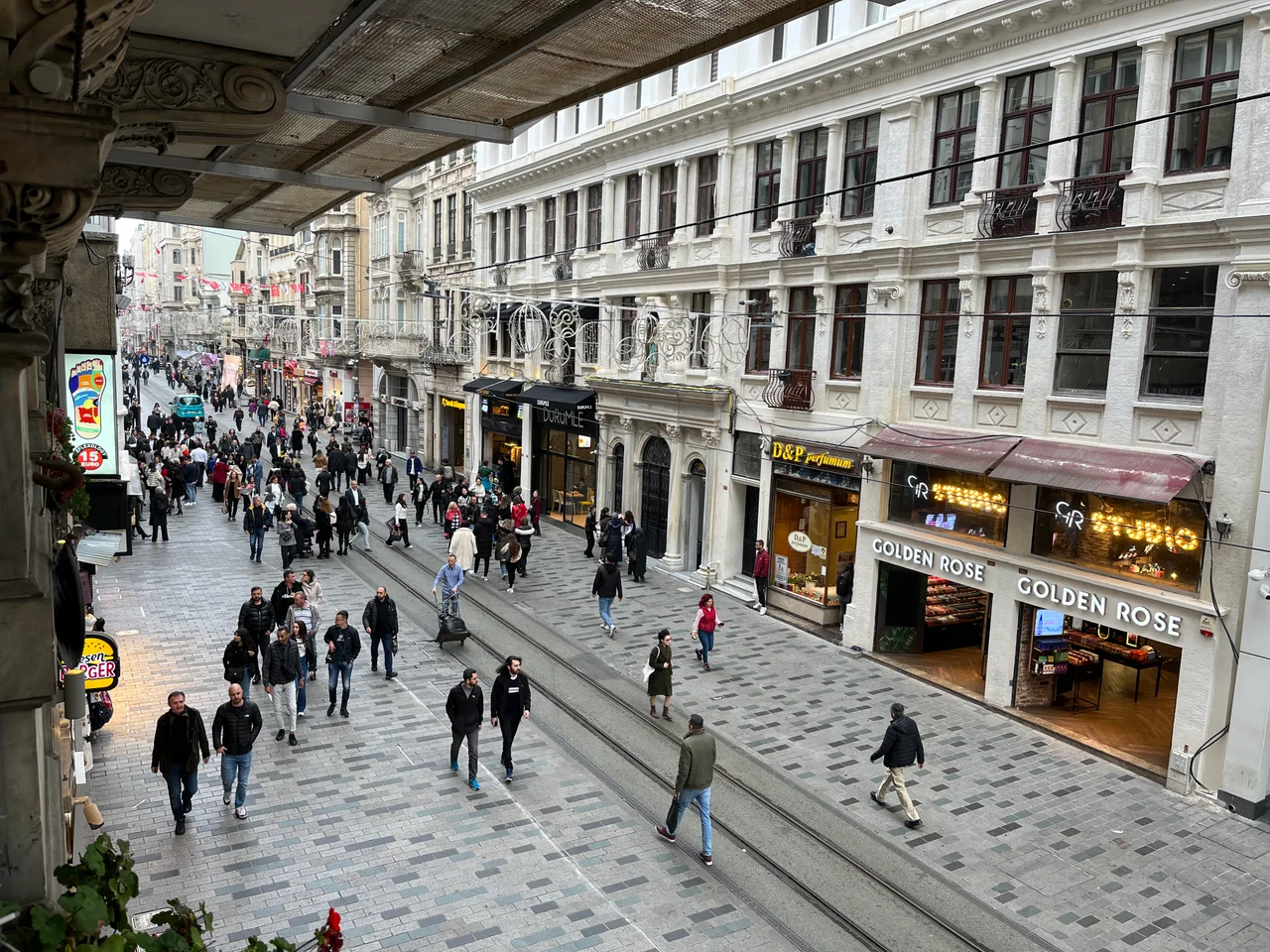

İstiklal Avenue
Walk it once and you understand why 19th-century European travelers called Constantinople the Paris of the East. They meant İstiklal Avenue specifically — or the Grande Rue de Péra, as it was then known — that long, wide boulevard where Ottoman intellectuals and Italian Levantines and Greek merchants and French diplomats jostled past each other on the same pavement. The street is 1.4 kilometers from end to end, running between Tünel Square at its southern foot and Taksim Square at its northern crown, and almost every step carries a story.
A Name Hard-Won
The avenue's current name dates to 29 October 1923 — the day Turkey declared itself a republic. İstiklal means independence, and the renaming was deliberate: this was the street where cosmopolitan Ottoman culture had flourished, and now it would carry the banner of a new national identity. Before that, it had been the Cadde-i Kebir, Grand Avenue in Ottoman Turkish, or the Grande Rue de Péra in French — Pera being the old name for the hilltop neighborhood now called Beyoğlu. The buildings along it mostly date from the late 19th and early 20th centuries, a catalogue of European revival styles: Neo-Classical, Neo-Gothic, Renaissance Revival, Beaux-Arts, Art Nouveau. Among them, a handful of Art Deco buildings from the early Republican years mark the moment when one era ended and another began.
The Architecture of Cosmopolitanism
Walk the avenue and you pass Catholic and Greek Orthodox churches, an Armenian church in the nearby Fish Market, mosques, and the consulates of France, Greece, Russia, Sweden and the Netherlands — embassies until 1923, when the diplomatic corps followed the capital to Ankara. Schools founded by Austria, France, Germany and Italy in the 19th century still operate in the surrounding streets. Galatasaray Square marks the midpoint, anchored by the Galatasaray High School, the oldest secondary school in Turkey, its origins stretching back to the Ottoman palace school of the 15th century. The 1973 monument in the square commemorates the republic's 50th anniversary. The avenue's side streets run off it like the ribs of a spine, and within them — the Çiçek Pasajı, the Flower Passage, crammed with restaurants and taverns; the narrow Yeşilcam Sokağı, named for Turkey's film industry that occupied these blocks between the 1950s and 1970s.
Beneath the Pavement, History
At the southern end of İstiklal, a modest entrance marks the Tünel — the world's second-oldest underground railway, which has been carrying passengers down the steep slope from Beyoğlu to the Karaköy waterfront since 1875. A red-and-cream historic tram runs the length of the avenue every 15 minutes, its bells audible above the crowd. The avenue fell from fashion in the 1970s and early 1980s, when longtime Istanbulite families moved elsewhere and the side streets filled with migrants from rural Anatolia. Then, in the late 1980s and 1990s, the Istanbul Metropolitan Municipality and Beyoğlu Municipality invested in restoration: buildings were repaired, the street was pedestrianized, the trams reinstated. The avenue came back.
Shadows on the Stones
Not all the history here is celebratory. On 6–7 September 1955, an anti-Greek pogrom swept through the city; along İstiklal Avenue, shops owned by Greek residents were pillaged, pavements strewn with broken glass and scattered belongings. The event accelerated the departure of the city's Greek community. Decades later, the avenue has twice been targeted by bombers: an Islamic State suicide bombing on 19 March 2016 killed five people; on 13 November 2022, a bomb explosion killed six people and left 81 injured. These events cast long shadows over a street that has always represented Istanbul's aspiration toward openness and shared life. Since the Gezi Park protests of 2013, gatherings — including the Istanbul Pride march and International Women's Day events — have been effectively banned on the avenue, citing security.
The Street Today
On any given afternoon, İstiklal is a current: thousands of people flowing in both directions, past boutiques and music shops, art galleries and cinemas, the historic patisseries that have managed to survive the arrival of international chain stores. The Yapı Kredi Art Gallery, SALT Beyoğlu, Akbank Sanat, and the Meşher Art Gallery give the avenue genuine cultural weight. The Istanbul Film Festival uses venues in and around the street. At Galatasaray Square, photographers set up in front of the school gate. At Çiçek Pasajı, the evening crowds gather early. The avenue carries the full weight of Istanbul's contradictions — secular and devout, European and Anatolian, joyful and troubled — and manages, somehow, to hold all of them.
From the Air
Coordinates: 41.034°N, 28.979°E. İstiklal Avenue lies on the Beyoğlu ridge above the Golden Horn, running roughly north-south between the rooftops of one of Istanbul's densest districts. From altitude, the Galata Tower — a medieval Genoese watchtower that rises just south of Tünel Square — serves as the best landmark for locating the street's southern end. Taksim Square's open plaza marks the northern terminus. Istanbul Airport (LTFM) is approximately 40 km to the northwest. Recommended viewing altitude: 2,000–4,000 feet on the European approach, looking southeast toward the Bosphorus.
Nearby Stories
- Kocaeli Peninsula 7.6 km away
- Second Battle of Çatalca 11 km away
- Istanbul's Rural Outskirts 14 km away
- MV Struma 20 km away
- HMAS AE2 36 km away
- Bursa 66 km away
- Sangarius Bridge 71 km away
- Januarius MacGahan 101 km away