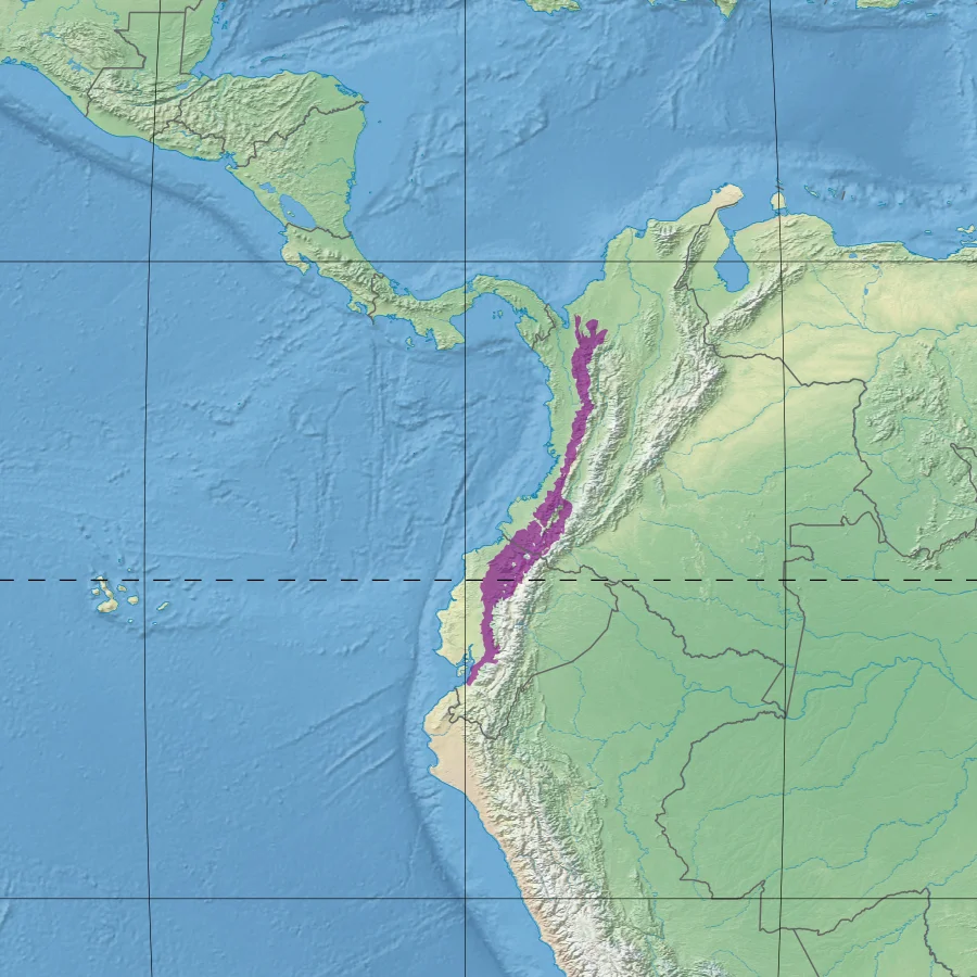
Northwestern Andean Montane Forests
Drop a one-hectare plot anywhere in the Northwestern Andean montane forests and wait for the botanists. They can tag up to 300 species of flowering plants inside those 10,000 square meters - a density so extravagant it turns ordinary European or North American forests into monocultures by comparison. About half of those plants grow nowhere else on the planet. The forest drapes the western range of the Andes in Colombia and Ecuador, lit by the sun, soaked by trade winds, and packed into such a narrow vertical band that walking half an hour uphill crosses climate zones that would take hundreds of kilometers to cross at lower latitudes.
A Long Green Ribbon
The ecoregion extends along the Cordillera Occidental - the western range of the Andes - in both Colombia and Ecuador. It covers about 8,132,562 hectares, making it roughly the size of Austria. In the extreme north it melts into the Magdalena-Urabá moist forests. Through most of its length it faces the Chocó-Darién moist forests on the west and the Cauca Valley montane forests on the east. Higher up, the trees give way to the Northern Andean páramo; lower down at the southern end, the forest dries out into the Tumbes-Piura dry forests. This vertical and horizontal stacking of ecoregions is exactly what makes the tropical Andes one of the two or three most biodiverse places on Earth.
Why So Many Species
The explanation sits partly in the ice ages. During glacial periods, cool climate zones expanded and connected while warm zones shrank into isolated refugia. During warm interglacials - like the one we live in now - the reverse happened: warm zones climbed uphill and reconnected while cool zones broke into islands. Species adapted to either condition spent millions of years being stranded and reunited, isolated and mixed, cycle after cycle. The result was continuous speciation. Every time populations split, new species formed. Every time they reunited, hybrids and competitors appeared. About 50% of the flora is strictly endemic. The climate today - humid, tropical, with 2,000 to 4,000 mm of annual rainfall at most elevations - keeps the engine running. At a typical sample location, mean temperatures range from 25.8 °C in November to 26.4 °C in March. Rain falls in nearly every month.
The Fauna of the Middle Elevations
The forest holds some of the hemisphere's rarest mammals. Baird's tapir (Tapirus bairdii), the largest native land mammal of Central America. The black-headed spider monkey (Ateles fusciceps) and Geoffroy's spider monkey (Ateles geoffroyi), both endangered. The cotton-top tamarin (Saguinus oedipus), a small primate with a crest of white hair, endemic to Colombia and critically endangered. The northern pudu (Pudu mephistophiles), among the smallest deer in the world. Mountain tapirs (Tapirus pinchaque) at the upper margins. Jaguars, still moving through the larger blocks of forest. The birds are stranger - glass-winged hummingbirds, the black-and-chestnut eagle (Spizaetus isidori), and the iridescent colorful puffleg (Eriocnemis mirabilis), known from a handful of specimens in the Colombian Andes.
The Frogs of the Andes
The amphibian list reads like a specialist's novel. Atelopus stubfoot toads in a dozen varieties, many found only on a single mountain ridge: the Azuay, the Chocó, the Pirri harlequin frog, the Mindo stubfoot toad. Centrolene glass frogs, their bellies so translucent you can watch their hearts beat. Pristimantis rain frogs - more than two dozen in this ecoregion alone - the Sharpsnout, the Murri, the Fern-loving, the Cloud forest. Lehmann's poison frog (Oophaga lehmanni), blood-red on black, found only in a small valley of Colombia's Cordillera Occidental. The forest's frog diversity is a measure of its humidity, its complex topography, and its deep geological time. Many of these species are endangered by chytrid fungus, a global amphibian disease that arrived in the Andes in the late twentieth century and has been moving through the montane forests ever since.
The Human Layer
This climate is hospitable to people. It has been since before the Spanish arrived: indigenous societies farmed its slopes, pastured livestock, and built the terraces that still shape some hillsides. Since the colonial period, the pace has picked up. The World Wide Fund for Nature rates the ecoregion as Vulnerable. About 15% of it is in protected areas. The list of parks is long: Cayambe Coca, Sangay, Cotopaxi, and Cajas in Ecuador; in Colombia, Farallones de Cali, Las Orquídeas, Munchique, Paramillo, Puracé, Tatamá, and the Doña Juana-Cascabel Volcanic Complex. Outside the parks, coffee, cattle, and small towns fill the slopes. The work of conservation here is less about preserving wilderness than about stitching together what remains - forest corridors that let the tapirs and jaguars move, the frogs breed, and the plants keep speciating.
From the Air
The Northwestern Andean montane forests run along the western cordillera from northern Colombia into southern Ecuador. A central reference point is 0.93°N, 78.12°W, near Cotopaxi. Elevations range roughly from 1,000 m to 3,200 m. Major nearby airports include Quito Mariscal Sucre (SEQM), Cali Alfonso Bonilla Aragón (SKCL), and Medellín José María Córdova (SKRG). Expect persistent orographic cloud on the windward (western) slopes; the clearest views of the forest canopy are usually in the first hour after sunrise.
Nearby Stories
- Sanctuary of Las Lajas 22 km away
- San Miguel (Ecuador) 31 km away
- Inca-Caranqui 44 km away
- Mira River 54 km away
- Mindo 82 km away
- Tumaco 88 km away
- Sumaco Napo-Galeras National Park 122 km away
- San Agustín culture 174 km away