
Reich Harvest Thanksgiving Festival
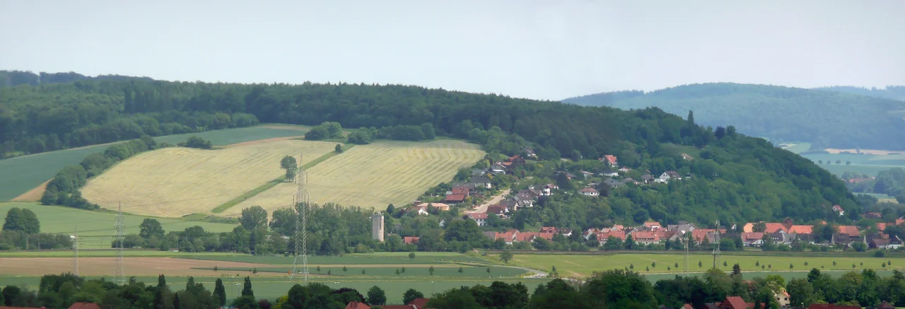
From across the Weser valley the Bueckeberg looks like any other Lower Saxon hillside - pasture, hedgerows, a scatter of trees. Then you notice the line. A strip of grass runs straight up the slope, paler than the field around it, ignoring the contours and the field boundaries because it was never a field boundary. It is the foundation of an elevated paved corridor five metres wide, built so that one man could walk up the hill by himself while several hundred thousand people watched him do it. Between 1933 and 1937 the Nazi Party staged its Reich Harvest Thanksgiving Festival on this slope, five kilometres south of Hamelin, and by the last of them the crowd was larger than anything the party ever assembled at Nuremberg. Nothing was manufactured here and nobody died here. What was produced was a picture, and the hill was the camera.
A Hillside Built for One Walk
Joseph Goebbels handed the design to Albert Speer, and Speer read the terrain rather than fighting it. An oval of meadow about eighteen hectares in size formed a natural bowl; he ringed it with swastika flags on thousands of poles, put a pyramidal speaker's platform some forty metres wide across the bottom, and set an honour tribune roughly a hundred metres wide, seating three thousand, at the top. Between them ran the raised causeway the regime called the Fuehrerweg. The early plans made a point of rustic plainness, on the theory that farmers would distrust anything that looked like a city, but the plainness was itself a decision taken in an office in Berlin. Every element served one shot: a lone figure climbing a slope through an enormous crowd, framed by flags, filmed from above. Speer would use the same instinct at Nuremberg. Here he had the advantage of a real hill.
The Arithmetic of a Crowd
Roughly half a million people came in 1933, around seven hundred thousand in 1934, and by 3 October 1937 the figure given was 1.2 million or more. The numbers came from the propaganda ministry and were almost certainly rounded upward, but even a discounted version outranks every other Nazi ceremony. Getting them there was the work of the Reichsnaehrstand, the corporate body that the regime had imposed on German farming, under Richard Walther Darre as Reich Farm Leader. Most of those who travelled had no interest in Darre's racial theories about blood and soil and probably could not have summarised them. What reached them was flattery: they were the people of the land, the nurturing estate, the ones who fed the country - and a rural population that had spent the Depression feeling ignored found being told this in front of a million witnesses very hard to refuse. The ceremony's climax was small and domestic on purpose. A farm woman stepped forward and handed over a woven harvest crown, reciting a rhymed dedication, and a state that ran on mass spectacle accepted its authority from a countrywoman with a wreath.
The Hour of Gunfire
From 1935 the harvest festival ended with a battle. Wehrmacht units deployed on the ground below the main slope and staged an assault for the crowd; in 1937 the display ran more than an hour and involved artillery, tanks, aircraft overhead and something like ten thousand soldiers, finishing with the demolition of a purpose-built mock village that the troops had nicknamed the Meckererdorf - the grumblers' village. The rhetoric matched the gunnery. Speaking on 3 October 1937, Hitler demanded that Britain be reasonable, raised the question of colonies, and told the crowd that the garden Germany had cultivated it would harvest alone, and that no one should imagine they could break into it. Two years later the units that had rehearsed on this hillside were in Poland. It is worth being plain about what the Bueckeberg was: not a country fair with politics attached, but a political rally that borrowed the shape of a harvest festival, and closed each year with a demonstration of what the state intended to do with its army.
The Grass and the Argument
The festivals stopped after 1937 and the site was left to the grass. For decades it read as ordinary farmland, which is precisely what made it awkward: there was no ruin to point at, no fence, nothing that announced itself. Look closely and the evidence is all still there - the Fuehrerweg as its pale stripe, concrete footings from the tribune, fragments of rostrum and service infrastructure under the turf. In 2008 someone painted a demand across the grounds: Kein Denkmal den Taetern. Gedenkt der Opfer! - no monument to the perpetrators, remember the victims. It named the difficulty exactly. The people this hill commemorated came here voluntarily, in their hundreds of thousands, and the ones who paid for what followed were somewhere else entirely. The answer arrived in 2021, when a documentation and learning site opened on the slope itself, explaining the ground rather than marking it. You walk the same line, and this time something tells you what you are walking on.
From the Air
The Bueckeberg festival ground lies at 52.0547N, 9.4022E, on the south-eastern flank of the Bueckeberg ridge near Hagenohsen in the municipality of Emmerthal, about 5 km south of Hamelin in Lower Saxony. The Weser runs immediately west of the site through a broad valley, and the terrain rises east of the river to wooded ridges - the ground is far from flat, so plan a route along the valley rather than across it. From 1,500 to 3,000 feet AGL the old Fuehrerweg is often discernible as a straight pale line running up the open slope, most visible in low, raking light in spring and autumn when grass colour contrast is strongest; from directly overhead at midday it usually disappears. Hamelin's old town, the Weser weir and the river's sharp bends make the easiest run-in. Bad Pyrmont airfield (EDVW, 600 m asphalt, elevation 359 m) is about 20 km south-west; Hannover (EDDV) roughly 45 km north-east. Valley fog is common on autumn mornings here, and the ridges either side of the Weser generate mechanical turbulence in a westerly.
Nearby Stories
- PS Speicher 4.2 km away
- Bernward Doors 7.7 km away
- Holzminden prisoner-of-war camp 10 km away
- Heinz Nixdorf MuseumsForum 14 km away
- Bielefeld conspiracy 21 km away
- Herrenhausen Gardens 26 km away
- Celle State Stud 30 km away
- Dümmer 33 km away