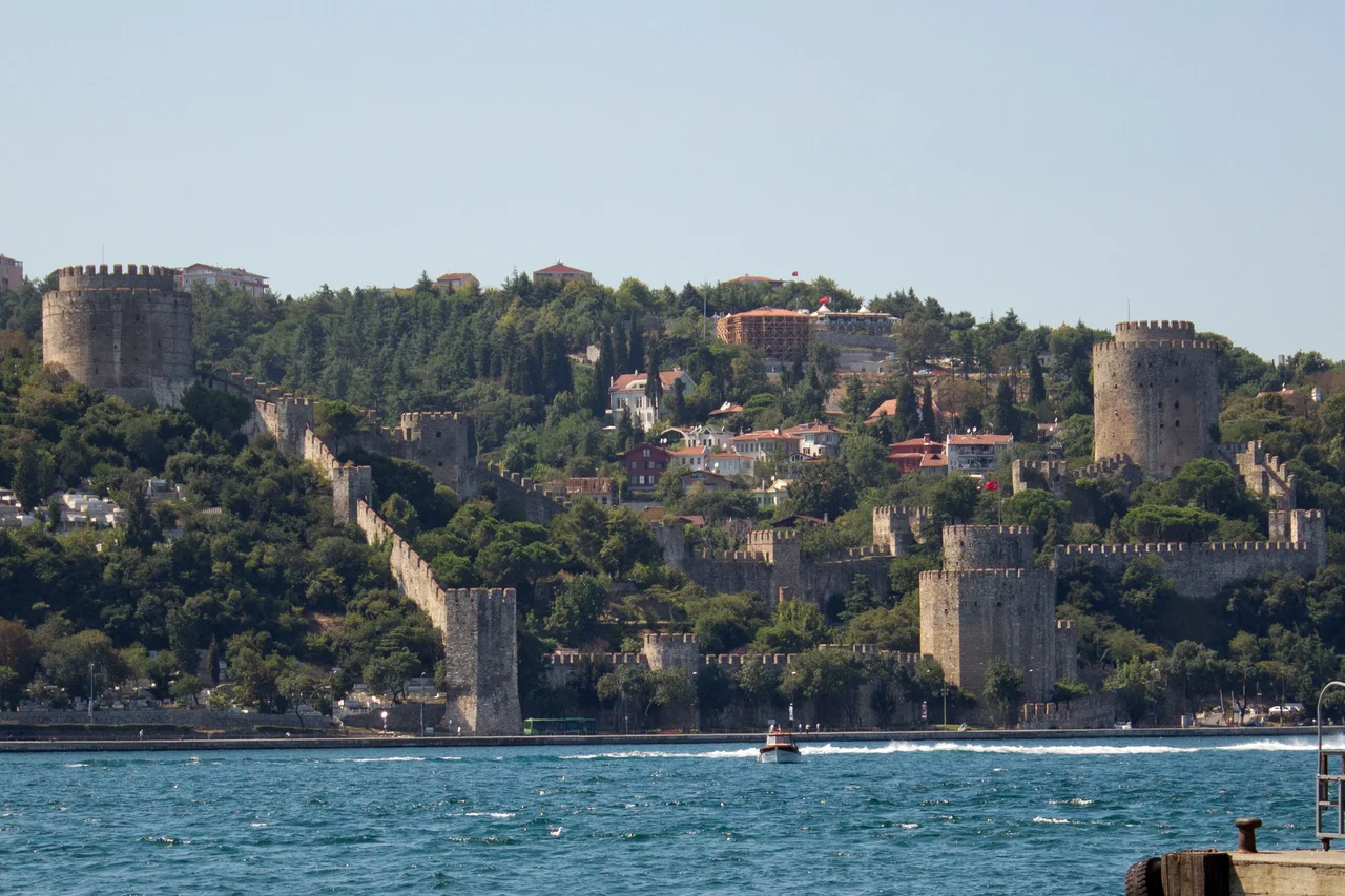

Rumelihisarı
The word 'Boğazkesen' has two meanings in Turkish. Boğaz means strait — and Boğaz also means throat. Mehmed II named his new fortress both things deliberately. Construction began on April 15, 1452, on the narrowest point of the Bosphorus, where the European and Asian shores are only 660 meters apart. The young sultan had one purpose: to cut off Constantinople from any naval relief before he besieged it. He stationed 400 Janissaries inside, aimed cannons from the main waterfront tower, and made his message clear almost immediately: a Venetian vessel that ignored signals to stop was sunk with a single shot, its surviving sailors beheaded, its captain impaled as a warning visible from the strait. No ship passed Rumelihisarı after that without Ottoman permission. Constantinople fell the following year.
Four Months That Changed Everything
The speed of Rumelihisarı's construction was itself a military statement. Mehmed II began it in spring 1452 and finished it by late summer — a fortification of three main towers, thirteen watchtowers, and curtain walls enclosing 31,250 square meters, completed in roughly four months. The sultan personally inspected the work site. Each of the three main towers was named after the vizier who supervised its construction: Çandarlı Halil Pasha's tower sat by the gate, Zağanos Pasha's tower anchored the south, and Sarıca Pasha's tower the north — the last also known today as the Fatih Tower, for Mehmed's cognomen, 'the Conqueror.' The fortress's floor plan, seen from above, encodes the initials of Mehmed and the Prophet Muhammad in its layout. Nothing about this structure was incidental. It was an instrument of war designed with the precision of a siege engine, set into a hillside that had held Roman fortifications and later a monastery — layers of previous strategic thinking that Mehmed was now overwriting with his own.
Engineering the Siege
Rumelihisarı did not stand alone. Directly across the Bosphorus on the Asian shore sat Anadoluhisarı — the Anatolian Fortress, built by Sultan Bayezid I between 1393 and 1394. Together, the two fortresses formed a pair of jaws across the strait. No ship from Genoese colonies along the Black Sea — Caffa, Sinop, Amasra — could bring supplies to Constantinople without running their cannon. Byzantine Emperor Constantine XI had watched Rumelihisarı going up and understood what it meant. He had tried, in the classic Byzantine manner, to forestall the war by diplomatic pressure, releasing a pretender to the Ottoman throne named Orhan as a threat of civil conflict. Mehmed was not deterred. The fortress rose, the cannons were emplaced, and the following spring the final siege of Constantinople began. The city fell on May 29, 1453. Rumelihisarı's role in that conquest was decisive: it had already won the naval battle before the land assault even started.
Prison, Ruin, and Resurrection
After the conquest, the fortress found new uses. It became a customs checkpoint controlling traffic through the strait. In the 17th century it served as a prison, particularly for foreign ambassadors whose countries were at war with the Ottoman Empire. An earthquake in 1509 damaged it significantly, and it was repaired; a fire in 1746 destroyed the wooden structures inside two of the main towers. Sultan Selim III ordered further repairs in the late 18th century. Then, in the 19th century, the fortress was abandoned and a residential neighborhood quietly grew up inside its walls — families moving into what had once been a military stronghold, planting gardens among the towers. This ended in 1953, when President Celal Bayar ordered the inhabitants relocated. Restoration began on May 16, 1955, and lasted until May 29, 1958 — dates chosen deliberately to align with the anniversaries of the conquest. Since 1960, Rumelihisarı has been a museum and, in summer, an open-air concert venue.
What Survives in Stone
Walking through Rumelihisarı today, the scale becomes clear in a way that photographs cannot quite capture. The Sarıca Pasha Tower is 28 meters high, its cylindrical walls 7 meters thick. The Halil Pasha Tower at the waterfront is a twelve-sided prism — a dodecagonal form unusual in Ottoman military architecture — with walls 6.5 meters thick. The original conical wooden roofs, once covered in lead, are gone, lost to the 1746 fire. One of three original wall-fountains remains. The minaret shaft of the original mosque built within the fortress still stands; the mosque itself did not survive. What does survive is the essential geometry of the place — the way the walls follow the hillside, the way the towers command the water, the way the Bosphorus narrows between them as if squeezed by the fortress's very presence. The Fatih Sultan Mehmet Bridge, named for the sultan who built Rumelihisarı, stands a short distance to the north, a modern span connecting the same two shores that Mehmed II strangled into submission in the summer of 1452.
From the Air
Rumelihisarı sits at 41.085°N, 29.056°E on the European shore of the Bosphorus, approximately 10 km north of central Istanbul. Approaching from Istanbul Airport (LTFM) to the northwest, the fortress is one of the most recognizable visual landmarks from the air — its three towers and curtain walls clearly visible against the hillside above the strait. The Bosphorus narrows sharply at this point; the Fatih Sultan Mehmet Bridge is visible just to the north, and the smaller Anadoluhisarı fortress on the Asian shore directly across completes the historical pair. Recommended viewing altitude: 1,500–3,000 feet for the best view of the fortress's geometry and its relationship to the strait. In clear conditions, the fortress is visible from significantly higher altitudes due to its prominent waterfront position.
Nearby Stories
- Kocaeli Peninsula 7.6 km away
- Second Battle of Çatalca 11 km away
- Istanbul's Rural Outskirts 14 km away
- MV Struma 20 km away
- HMAS AE2 36 km away
- Bursa 66 km away
- Sangarius Bridge 71 km away
- Januarius MacGahan 101 km away