.jpg)
Siege of Bergen op Zoom (1747)
When the French finally came through the breach at four in the morning on 18 September 1747, the Dutch garrison commander was asleep in his bed. Cronstrom was eighty-six years old. He had been defending Bergen op Zoom for sixty-six days against a French army of thirty thousand, and his lieutenants had assured him that the fortifications were still holding. They were not. By the time he was woken, French grenadiers were already inside the gates, and Loudon's Highlanders were making a last stand in the market square. He escaped through the streets in his nightshirt. Two-thirds of the Highlanders did not.
The Fortress That Could Not Fall
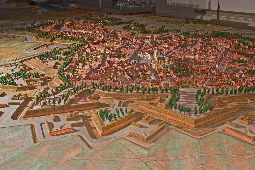
Bergen op Zoom sat where the province of Brabant rolled into the marshes of Zeeland, and for a generation it had been the most fearsome thing the Dutch Republic could put on a map. Three miles of ramparts. Ten bastions. Five hornworks. Twenty-one ravelins shielded by stone lunettes, each one named after a Dutch province or a Dutch city. The whole complex was the masterwork of Menno van Coehoorn, the engineer the Dutch claimed as their answer to Vauban, and it ringed a town of five thousand civilians and a garrison of three thousand soldiers. Much of the surrounding land could be flooded on command. The harbour stayed open to the sea, so Dutch ships kept the place supplied. To the northeast, an entrenched camp at Roosendaal held twenty battalions and fourteen squadrons of cavalry ready to reinforce or relieve. It was, the Dutch insisted, impregnable. Which is the kind of word that, in 1747, tended to bring out the French.
The Specialist
Marshal Maurice de Saxe had just won the Battle of Lauffeld, and he understood his enemy's geometry. He could not stretch his army across two fortified Dutch cities at once. So he handed Bergen op Zoom to the man who knew how to break this kind of thing: Ulrich Frederic Woldemar, Comte de Lowendal, thirty thousand troops at his back and a reputation as a master of siegecraft. Lowendal arrived in July. On the night of the 14th, twenty-four hundred French workers under cover of ten companies of grenadiers and five battalions of infantry opened the first trench, four hundred paces out from the walls. By 17 July the second parallel was dug. By 22 July the third. On 20 July the artillery batteries opened on the defenders, and a war of inches began. The fourth parallel was finished by 28 July. The fifth, laid right up against the works, came on 8 September. In between, the Dutch and French fought a subterranean war of mines beneath the bastions Coehoorn and Pucelle. Seventy-five mines were sprung in that one sector alone - forty-three by the Dutch, thirty-two by the French.
Loudon's Highlanders
The defenders were not only Dutch. The allied garrison was a small confederation of nations united by the Pragmatic Sanction: Dutch infantry, Austrian engineers, Hessian battalions, two Scots battalions under Colyear and Majoribanks, and the 64th Foot - Loudon's Highlanders - who had marched south from the glens to find themselves manning bastions in a Dutch marsh. On 25 July the Highlanders made a sally from Fort Rover, attacked a major French battery, and destroyed it. When the breach came two months later, they were the ones who fought through the streets of Bergen op Zoom hand to hand, holding the market place long enough for old Cronstrom to slip out the back. They lost two-thirds of their number doing it. The Dutch and their allies suffered around three thousand casualties in the storm and the sack that followed. French losses were 479. Two hundred fortress guns and seventeen fully loaded supply ships were captured in the harbour.
What the Storm Cost
The civilian price of an eighteenth-century sack does not appear in the order of battle. Bergen op Zoom had a population of around five thousand before the siege opened. When French troops entered the city sword in hand, those people were on the receiving end of what contemporaries simply called 'the sack' - looting and worse, by an army that had spent two months losing men in those same streets and was not inclined to mercy. The Wikipedia summary records only the casualty count for the garrison. The number for the townspeople is not recorded in this account at all, which is itself the story: in this kind of warfare, soldiers on both sides at least had a name and a regiment. The civilians of Bergen op Zoom were the silent third army inside their own walls.
Aftermath, and a Treaty Forced by a Breach
Lowendal was made Marshal of France for the exploit. The capture handed France control of the entire River Scheldt, opened the Dutch Republic and the Electorate of Hanover to potential invasion, and shattered what remained of trust between the Dutch and British allies - the British had reasoned that since the Dutch had not formally declared war on France, they could not be expected to relieve every Dutch fortress, and the Dutch found the argument unforgivable. Together with the defeat at Lauffeld, Bergen op Zoom drove the British back to the negotiating table at the Congress of Breda. The Treaty of Aix-la-Chapelle followed in 1748. A young English volunteer named Jacob von Eggers, who had watched the siege from the French side, published an account that was read across Europe. The fortress that Coehoorn had built to be unbreakable had, in the end, served its purpose: not by holding, but by being lost so spectacularly that everyone wanted the war to stop.
From the Air
The siege took place at modern Bergen op Zoom, 51.50 N, 4.30 E, in the southwestern Netherlands. The star-shaped footprint of the old fortifications is still visible from the air as the ring of streets and parks encircling the historic centre. Best viewed 1,500 to 3,500 feet AGL on a clear morning, when shadows pick out the surviving bastion outlines. Nearest airports: Woensdrecht (EHWO) about 4 nm south, Antwerp-Deurne (EBAW) about 23 nm south, Rotterdam-The Hague (EHRD) about 27 nm north. The area sits beneath Schiphol-controlled airspace and adjacent to Woensdrecht military activity - expect heavy ATC coordination.
Nearby Stories
- Volkerakdam 1.4 km away
- Baarle-Hertog 2.6 km away
- Tomorrowland 6.7 km away
- Dussen Castle 6.9 km away
- Moermond Castle 8.2 km away
- Borssele Nuclear Power Station 11 km away
- Reginald Warneford 13 km away
- Basilica of Our Lady of Scherpenheuvel 20 km away