Volkerakdam
On 21 April 1966, two construction workers named M. Ten Hove and A. Roelants were digging out the casting basin for the Volkerak lock complex when they found something that did not belong in a 1960s engineering site: a small carved oak figure of a man. Radiocarbon analysis later dated it to the fifth millennium BC, more than six thousand years old, a Mesolithic survivor from the time before farming reached this part of Europe. They were excavating for one of the largest hydraulic projects in human history, the Delta Works, and they had just pulled a human image older than the Pyramids out of the Dutch mud.
The Night of 1953
On the night of 31 January and into 1 February 1953, a North Sea storm surge breached dikes across the southwest Netherlands. Nearly two thousand people drowned. The waters reached far inland. The Dutch government appointed a Delta Commission and resolved to close the inlets of Zeeland and South Holland with a system of dams unprecedented in scale. The Volkerakdam, the fifth project of the Delta Works, was conceived as a secondary compartmentalization dam, paired with the Grevelingendam, to reduce tidal currents across four estuaries so that the great primary dams further out, the Oosterscheldekering, the Brouwersdam, and the Haringvlietdam, could be built safely. The work begun under hydraulic engineer Johan van Veen evolved into a decades-long study of tides, sediment, and bathymetry, all in service of one goal: never let 1953 happen again.
Three Structures, Three Waters
The Volkerakdam is not a single wall. It is three distinct works crossing three different bodies of water. A solid dam runs from Goeree-Overflakkee to a man-made island called Hellegatsplein. A complex of locks runs from Hellegatsplein into North Brabant, allowing shipping to pass between Rotterdam and Antwerp. And a bridge runs from Hellegatsplein north to the Hoeksche Waard. These works span the Haringvliet, the Hollands Diep, and the Volkerak in turn. The original plan was to dam the Volkerak farther south at the level of the Dintel river, with a shorter dam. Feasibility studies showed the advantages of moving the works northward and adding the bridge crossing. The bigger plan won. The result reshaped not only the physical layout of the southwest Netherlands but its salinity, its tidal range, and its shipping economy.
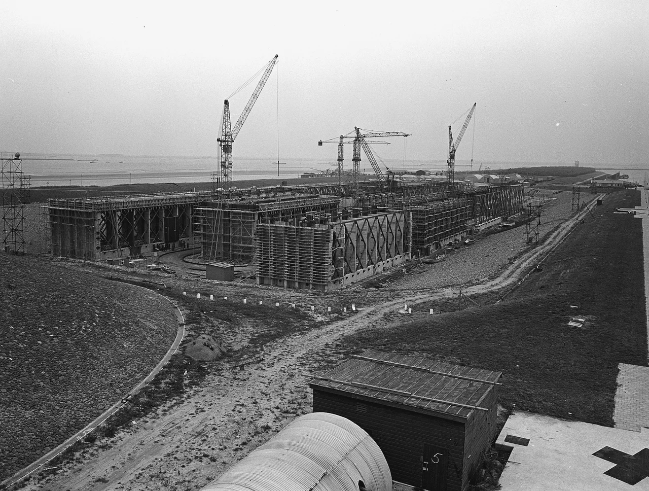
Caissons in the Casting Basin
The locks-and-dam section between Hellegatsplein and North Brabant was assembled from fourteen massive concrete caissons, prefabricated nearby in a casting basin and then floated into place. The first construction phase, the section running from Overflakkee to Hellegat over a shallow sandbank, used about 1.8 million cubic meters of sand and cost the contractor Dirk Verstoep around six million Dutch guilders. The shock to the local tides was modest in that first phase because only one gully, the Ventjagersgaatje, had to be closed. The bigger closures came later. The full closure of the Volkerak was finally completed in 1969, captured in newsreels by Polygoon and rebroadcast across the country as a national achievement.
Changing the Sea
Closing the Volkerak rewrote the hydraulics of an entire region. Areas south of the dam saw their tidal range increase considerably. Areas to the north saw it decrease. The effect tapered as the distance to Rotterdam grew. Fresh Rhine water that had once mixed into the Oosterschelde estuary was diverted, allowing the Oosterschelde to keep a more stable salinity and a richer ecology. A fixed water level on the new Zeeland Lake made shipping between Antwerp and Rotterdam easier and protected the area from the Rhine's seasonal swings. The dam's environmental role was support for its bigger sisters, controlling freshwater inflow so the primary barriers further out could do their work. The whole system together is one of the largest deliberate alterations of a coastline ever attempted.
The Willemstad Man in Leiden
The carved figure that Ten Hove and Roelants pulled from the Volkerak casting basin in 1966 has been on display in the Rijksmuseum van Oudheden, the National Museum of Antiquities, in Leiden ever since. It is known as the Mannetje van Willemstad, the Willemstad Man, after the nearby star-shaped fortress town. He is small, weathered, and abstract, an oak human figure standing roughly upright. Whoever carved him stood somewhere on this estuary when sea levels were lower and the land lay differently. Then the sea rose. The figure was buried in silt. Seven thousand years later, in the middle of an engineering project meant to control the same sea that buried him, a Dutch construction worker found a Stone Age man waiting in the mud.
From the Air
Coordinates 51.69 N, 4.41 E. The Volkerakdam complex sprawls across the gap between Goeree-Overflakkee, the Hoeksche Waard, and North Brabant. Cruise at 4,000 to 6,000 feet to see all three structures: the dam, the lock complex, and the Haringvliet bridge. Nearest airports: Rotterdam The Hague (EHRD) 35 km north; Antwerp (EBAW) 45 km south. The fortified town of Willemstad lies just east of the lock complex, a perfect waypoint.
Nearby Stories
- A4 motorway (Netherlands) 3.2 km away
- Dussen Castle 5 km away
- Baarle-Nassau 6 km away
- Siege of Bergen op Zoom (1747) 6.6 km away
- Moermond Castle 6.7 km away
- Woerden Train Disaster 8 km away
- Battle of Walcheren Causeway 11 km away
- HMS Cressy 28 km away