Tip of Borneo
Two oceans collide at a rocky headland on the northern edge of the world's third-largest island. The Tip of Borneo -- Tanjung Simpang Mengayau in Malay, Tanjung Sampang Mangazou in the Rungus language -- is the point where the South China Sea meets the Sulu Sea, and the effect is visible from altitude: two bodies of water, each with its own current, color, and temperament, crashing together in a line of white foam. The Kudat Peninsula, which ends at this dramatic promontory, has been a landmark for sailors for centuries. According to local legend, pirates favored it as a landing point. During the great age of circumnavigation, Ferdinand Magellan's fleet reportedly stopped here to repair their ships.
Written in Stone
The peninsula that culminates at the Tip of Borneo was formed during the Early Miocene, roughly 20 million years ago. The Kudat formation consists of three distinct layers of sedimentary rock: a lower unit of predominantly sandstone, a middle unit where limestone beds appear among the sandstone and mudstone, and an upper unit of mixed proportions. Walking to the tip, visitors cross exposed rock that records this geological history in visible strata. The landscape is raw and windswept, shaped by the relentless energy of two seas grinding against each other. At the point itself, a bronze globe marks the coordinates -- latitude 7 degrees north, longitude 116 degrees east -- with a map of Borneo embossed on its surface.
A Crossroads of Empires
The Tip of Borneo has never been a destination in itself so much as a waypoint -- the corner you round when traveling between the great trading seas of Southeast Asia. For the Sultanate of Brunei, which once controlled northern Borneo, the peninsula marked the edge of their domain. For the Sultanate of Sulu, which received these northern territories around 1704 as payment for military aid during the Brunei Civil War, it was the gateway to their island empire. When the British arrived through the North Borneo Chartered Company in the late 19th century, Kudat -- the town nearest the tip -- became one of the first administrative centers in Sabah. The Rungus people, indigenous to this part of Borneo, have their own name for the headland: Tanjung Sampang Mangazou. Long before colonial boundaries carved up the region, this was simply where the land ended and the sea took over.
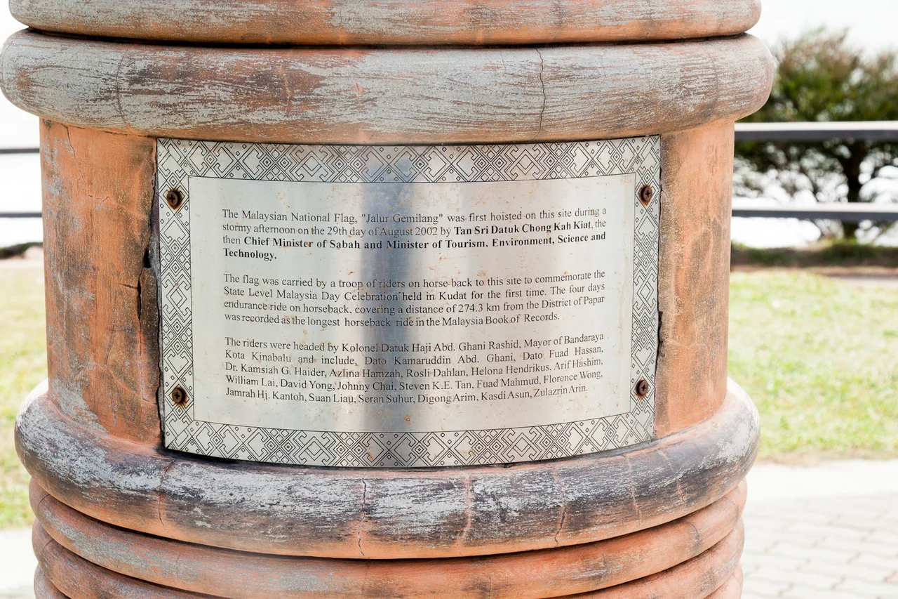
The View from the Edge
For years, the Tip of Borneo was an informal attraction -- a place you drove to on rough roads, parked, and walked to the cliff edge. In 2004, the Sabah state government formalized the site with the installation of the bronze globe landmark and interpretive signage. A cafe, souvenir shop, and washrooms followed. In January 2022, the entire site was closed for a major facilities upgrade under the Twelfth Malaysia Plan, a three-year renovation that reflected the government's growing ambition to make the tip a marquee tourist destination. The site reopened in May 2025 with improved infrastructure, park-like grounds, and better access. The upgrade was a bet on geography: there is only one northernmost point of Borneo, and no amount of development elsewhere can replicate the simple drama of standing at the edge where two seas meet.
Where the Seas Divide
The meeting of the South China Sea and the Sulu Sea at the tip creates distinctive water patterns visible even from considerable altitude. The South China Sea, stretching northwest toward Vietnam and China, carries commerce that has shaped global trade for millennia. The Sulu Sea, enclosed by Borneo, Palawan, and the Philippine archipelago, was once the domain of Sulu sultans and the Bajau sea nomads. Standing at the tip, the division is not abstract -- you can see the currents clash, watch waves approach from different angles, and feel the wind shift as it wraps around the point. The Kudat Peninsula catches weather from both seas, making this one of the most exposed and dramatic headlands in Southeast Asia. It is a place that reminds you that islands are not passive features but contested edges where geological and human forces meet.
From the Air
Located at 7.04N, 116.74E at the extreme northern tip of Borneo. The headland is clearly visible from altitude as the sharp northern terminus of the Kudat Peninsula, with ocean on three sides. The meeting of the South China Sea (west) and Sulu Sea (east) is sometimes visible as a color or wave-pattern boundary. Nearest airport is Kudat Airport (WBKT). Kota Kinabalu International Airport (WBKK) is approximately 190 km to the southwest. The nearby islands of Banggi and Balambangan are visible to the northeast.
Nearby Stories
- Cape Melville Lighthouse 50 km away
- Jambongan Island 61 km away
- Mari Mari Cultural Village 100 km away
- Turtle Islands National Park 105 km away
- HMS Pelorus (1808) 128 km away
- Gaya Island 128 km away
- Sepilok Orangutan Rehabilitation Centre 151 km away
- Tabon Caves 220 km away