Vale do Capão
Your phone probably won't work in Vale do Capão. That is not a warning so much as an introduction — the kind of small fact that tells you what kind of place you've arrived at. The village sits in a high green valley inside the Chapada Diamantina National Park, about 600 kilometres inland from Salvador, up in the spine of Bahia where the world opens into sandstone canyons and flat-topped mesas. The supermarkets here have no scanners; they tally your items on a pocket calculator and read the total back to you, slowly, so you can check. There is no ATM. There are internet cafés. There are trails.
Getting There Is the Point
Vale do Capão is connected to the outside world by a 4x4 road from the nearest town, Palmeiras, which is itself not large. Vans and pickups run the route a few times a day, timed to meet the intercity bus from Salvador — the Real Expresso bus climbs inland for six or seven hours through scrub and flat cerrado country before arriving in Palmeiras, and from there the last kilometres are gravel and dust. From Brasília the trip takes overnight buses and a change at Seabra. The journey filters the crowd. What you get at the end of it is a village of perhaps a thousand permanent residents, stretched along one main street, with pousadas, dormitories, campgrounds, and bungalows tucked into the green hills behind.
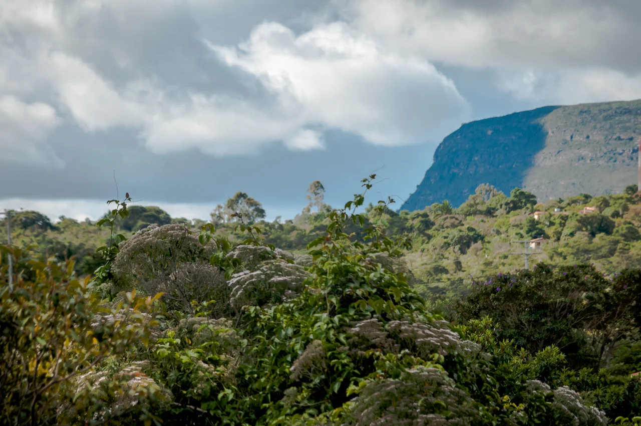
Chapada All Around
The Chapada Diamantina National Park surrounds the valley on all sides. Inside the park are some of the most celebrated natural wonders of interior Brazil: Cachoeira da Fumaça, the Smoke Falls, which at roughly 340 metres is one of the tallest waterfalls in the country, with its plume vaporising into mist before it reaches the bottom; the Poço Azul and Poço Encantado, two sunken cave pools where at certain times of year shafts of light penetrate clear groundwater to depths of sixty metres; long table-top mesas where condors ride the thermals. From Capão, most of these places can be reached on day hikes or multi-day treks. Some excursions require a guide. Others — the simpler trails, the closer waterfalls — can be done on foot or by hitchhiking, which is locally called pegar carona, to grab a lift.
The Tatu Feliz and the Trails
Finding a guide in Vale do Capão is easy; you ask, and someone's cousin or brother-in-law will appear. On the main street, a place called Tatu Feliz — the Happy Armadillo — offers a particularly wide menu of trekking options, from morning walks to the ten-day Grand Traverse that cuts across the Chapada's high plateau. Free hiking apps like OsmAnd and Mapy.cz show most of the local trails, and GPS traces on Wikiloc cover many of the standard routes around the valley. The trails go through dense gallery forest along the river bottoms, climb up into open campo rupestre — rocky highland savanna studded with bromeliads and terrestrial orchids — and then spill onto the mesa tops, where the wind is always moving and the horizon is stacked in flat blue layers to the curve of the earth.
An Alternative Pueblo
Since the 1970s, Vale do Capão has been a magnet for a particular kind of Brazilian: artists and hippies and back-to-the-landers, climbers and trekkers, people who wanted out of São Paulo and Rio and chose this valley as their counterweight. That legacy is still visible in the village's fruit-juice bars along the main street; in the small yoga retreats and permaculture schools in the surrounding hills; in the ease with which foreign and Brazilian visitors mingle with long-established residents. The local cachaça-based drink, PML, is short for Pinga Mel Limão — cachaça, honey, lime — a simple recipe that the village has adopted as its own. You can buy PML in the little bars in the centre. Or, as Wikivoyage notes pragmatically, you can buy the ingredients and make it at home.
A Quiet Place
Vale do Capão feels safe, people who live there say, in the ordinary sense of the word: a place where you can walk after dark without much worrying, where visitors and residents recognise each other after a day or two, where the pace is set by when the 4x4 leaves for Palmeiras. Cell reception is unreliable. The lights sometimes go out. The internet cafés are often full of travellers writing home. And at some point, almost everyone who comes to Vale do Capão finds themselves standing on a high mesa at sunset, watching the Chapada's layered cliffs turn pink and then red and then that deep blue just before full dark, and thinking that maybe the long bus ride was worth it after all.
From the Air
Vale do Capão sits at about 12.61°S, 41.50°W, deep inside the Chapada Diamantina highlands of central Bahia. The valley lies at roughly 900 metres elevation, with surrounding mesa tops reaching 1,400 metres or more — from cruising altitude the landscape shows as a chaotic system of flat-topped plateaus, deeply incised green valleys, and pale cliffs. There is no airport in the village itself; the nearest general-aviation strip is at Lençóis (SNNB), about 35 nm to the east, which is the main gateway for the Chapada Diamantina region. Salvador (SBSV) is approximately 250 nm east-northeast. Dry season (May–September) brings excellent visibility and dramatic thermal conditions over the cliffs; wet-season afternoon convection (November–March) can close the high valleys quickly. Cruising altitudes of 10,000–14,000 ft give the best view of Chapada's characteristic layered sandstone topography.
Nearby Stories
- Chapada Diamantina National Park 32 km away
- Manuscript 512 96 km away
- Morro do Chapéu State Park 110 km away
- Pé de Serra 173 km away
- Vitória da Conquista 228 km away
- Atlantic dry forests 235 km away
- São João de Deus Hospital 236 km away
- Caminho dos Gerais State Park 289 km away