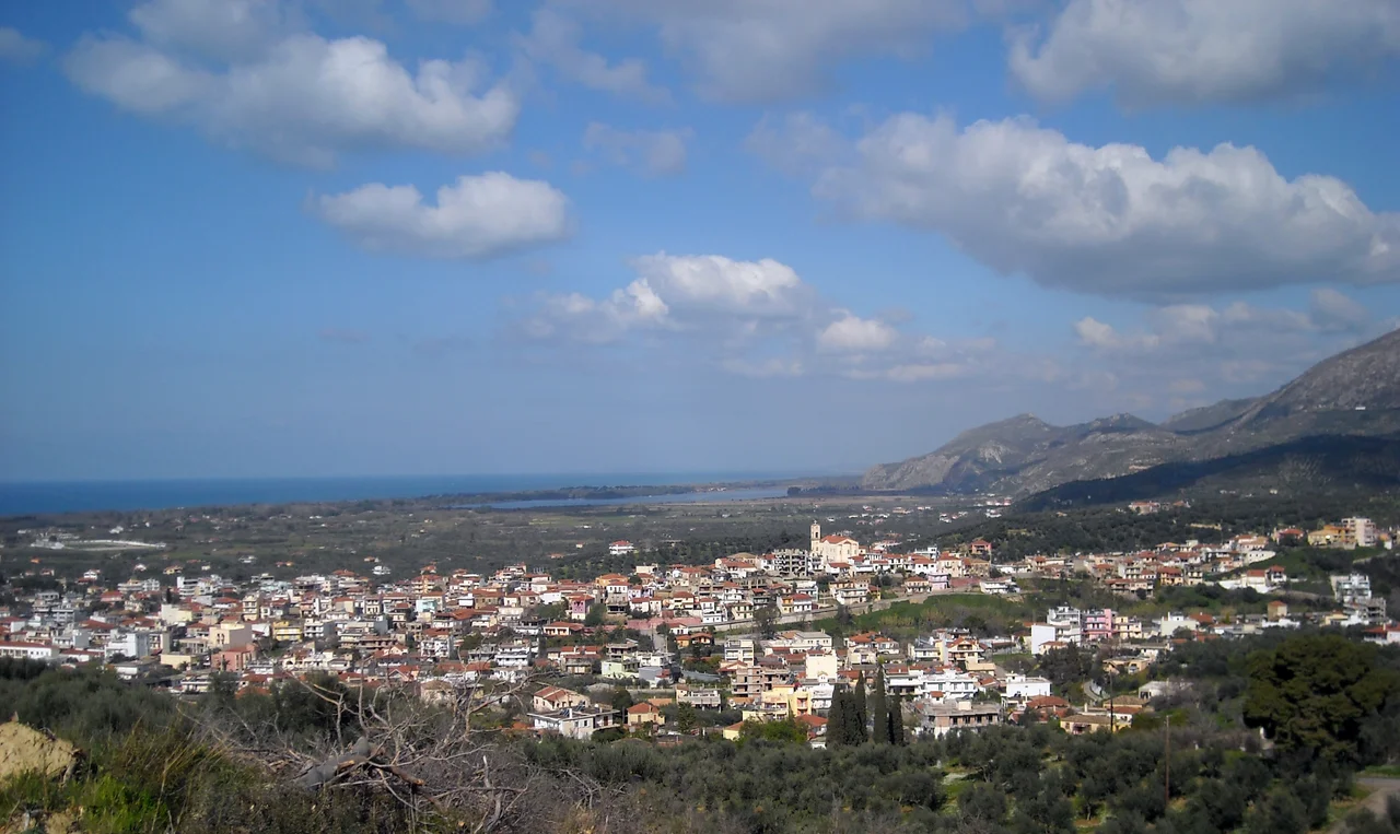

Zacharo
The town got its name from a woman named Zacharoula, who ran an inn here sometime before the modern settlement took shape. That detail — a community born from a roadside stop, named for its host — says something about Zacharo's character. It is a place of arrivals and returns, sitting where the Gulf of Kyparissia opens to the south and the pine-covered mountain of Lapithas rises behind the town. Long beaches run to the north. The thermal lake of Kaiafas nestles between the mountain and the sea. And somewhere in the surrounding fields, a tomato variety so dense with sugar that the crystals are visible to the naked eye has been quietly disappearing for decades.
A Town Made From Migration
Zacharo's recorded history begins in the mid-nineteenth century, which makes it young by Greek standards. During the War of Independence, the coastal plain here was sparsely populated. The mountains above held villages; their inhabitants eventually drifted down to the coast, drawn by the road, the flatland, and the sea. By 1881 Zacharo had become an official community. From that modest origin — a handful of families, an inn, a name from a woman nobody recorded a surname for — the town grew into a municipal center with schools, a lyceum, banks, churches, a football team (Olympiakos Zacharos, founded in 1928), and a square of platanus trees where the patron saint's feast day on December 12th still shuts the town down with celebration.
The Lake, the Springs, and the Koroneiki Olive
Northwest of the town, wedged between the skirts of Mount Lapithas and the sea, lies Kaiafas Lake — a lagoon fed by thermal springs and shaded by a forest of stone pines that crowds to the water's edge. The springs are sulfurous and warm, and people have been coming to them for medicinal reasons since antiquity; Strabo mentioned fetid waters in this part of the coast. Modern visitors come for swimming in the lake and the sea alike. The economy of the surrounding land runs on olive oil — specifically the Koroneiki variety, a small, intensely flavored olive considered among the finest in Greece. The oil produced here is extra-virgin quality, exported internationally. Less well-known but equally distinctive is the Zacharo tomato: a local cultivar so dense with fructose and inulin that sugar crystals form on the flesh when it ripens. It does not survive greenhouses, does not pack well, and its season is short. The variety is nearly extinct.
August 2007: The Fires That Burned Through Everything
In late August 2007, wildfires swept through the Peloponnese in what became one of the worst fire disasters in modern Greek history. The fires in Elis alone killed 45 people and left 3,500 residents homeless, burning through 8,500 hectares of forest and 2,300 hectares of farmland. Zacharo was among the worst-hit areas anywhere in Greece. Firefighters searching the roads found people dead in their cars. The nearby village of Artemida, a few kilometers from Zacharo, was completely destroyed; twenty-three of its residents did not survive. In all, more than 30 people died in the Zacharo area alone. The fires moved fast and gave little warning. The stone pines of Kaiafas burned. Olive groves that families had tended for generations burned. Houses burned. What followed was not a recovery so much as a rebuilding — of properties, yes, but also of a community that had seen in a few August days more loss than most places absorb in a generation.
The Coast Today
Zacharo's long beach — stretching south from the town along the Gulf of Kyparissia — draws summer visitors who come for the clean water and the relative quiet of a coast that has not yet been swallowed by resort development. The national road linking Patras to Kalamata passes through, giving the town a function it has always served: a stopping place on a long journey. The Kaiafas forest has grown back. The olive presses run in autumn. The football team still plays on the local pitch, and the football club founded nearly a century ago still bears the name Olympiakos. Saint Spyridon's feast day still shuts the town down in December. Zacharo is a place that has learned, over and over, how to start again.
From the Air
Zacharo lies at 37.486°N, 21.649°E on the Gulf of Kyparissia coast of the western Peloponnese. From the air, the town sits just inland from a long sandy shoreline, with the Kaiafas pine forest and lagoon visible as a dark-green patch to the northwest, and the ridge of Mount Lapithas rising behind. Approach from over the Ionian Sea at 3,000–4,000 feet heading east: the lagoon, the beach, and the town resolve into a clear coastal strip. Nearest major airport is LGRX (Araxos), approximately 50 km to the north. Olympia is 18 km to the east and can be identified from altitude by the Alpheius valley. Morning light best illuminates the coast and the pine forest.
Nearby Stories
- Aroanios 4.6 km away
- Kyparissia 4.7 km away
- Strofades 7.6 km away
- Arcadia (region) 9.1 km away
- Longanikos 9.5 km away
- HMS Perseus (N36) 21 km away
- Astras 23 km away
- St. Mark's Roman Catholic Church 34 km away