Zuma, Sudan
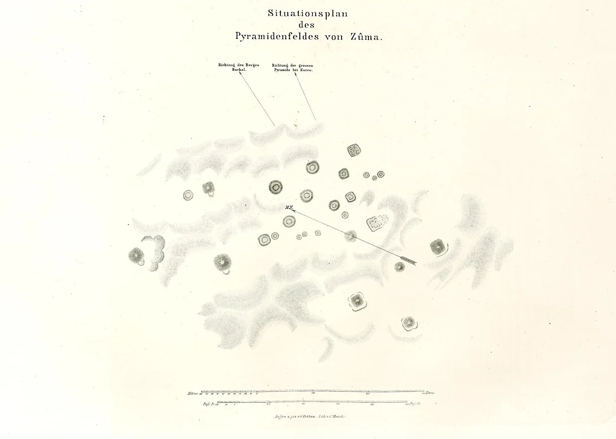
For most of the twentieth century, travelers who bumped along the right bank of the Nile south of Jebel Barkal would pass a cluster of curious earthen mounds and hear them called the El-Zuma Pyramids. The name has stuck in local memory for a century. It is not accurate. The twenty-nine mounds of el-Zuma are tumuli, not pyramids - stone-covered hills over underground burial chambers, built in the transitional centuries between the fall of the Kushite kingdom at Meroe and the rise of Christian Nubia. Karl Richard Lepsius drew a plan of them in the 1840s. For almost 160 years afterward, no one excavated.
The Napatan Region
El-Zuma lies about ten kilometers south of El-Kurru, in the heart of what archaeologists call the Napatan Region - a stretch of Nile bend where the old Kushite kings of Kush built capitals, pyramids, and temples for more than a thousand years. About twenty-five miles upstream stands Jebel Barkal, the sacred mountain the Kushites and Egyptians both considered a dwelling of Amun. This corner of Sudan holds some of the richest archaeology in Africa, much of it African in origin and too often read through an Egyptian lens. Zuma is not Egyptian. Its tumuli belong to a Nubian tradition, and they were raised when the old Kushite order was dissolving into the Makurian Christian world that would rise along this same river.
Three Kinds of Mound
The 29 surface mounds at Zuma fall into three distinct types, and the difference tells you something about the social order they memorialize. Type I tumuli are the largest - diameters of twenty-five meters or more, six meters tall, completely covered in stones. Type II mounds are slightly smaller, with diameters around twenty-one meters, built of sand and loose stones held in place by a ring of larger stones at the base. Below both, the burial shaft descends in an M-shape when seen from above, opening into two chambers - one for the deceased, the other for grave goods. Type III are small and flat, less than a meter high, nine meters across, with only a single grave chamber. The eight largest tumuli almost certainly belonged to an elite. The smaller ones did not.
Tumuli 6 and 7
The most elaborate burials lie at the highest point of the site, where two tumuli - numbered 6 and 7 in the archaeological record - have tunnels divided by rows of pillars, as if the architects wanted a subterranean colonnade for the dead. These were not ordinary graves. Whoever rested here commanded the labor of many, the wealth to commission stone pillars underground where almost no one would ever see them, and the prestige to claim the site's commanding ground. All the chambers at el-Zuma were robbed in antiquity - a fate common to every spectacular cemetery in the region. What the tomb robbers left behind is still enough to read: pottery, beads, metal fragments, animal bones. The ceramics date to the late fifth and early sixth centuries CE.
The Polish Team
Systematic excavation finally began in December 2004 when a Polish-Sudanese team led by Mahmoud el-Tayeb of the Polish Centre of Mediterranean Archaeology at the University of Warsaw opened the site as part of the Early Makuria Research Project. They have been returning ever since, slowly reading the evidence: how the mounds were raised, what kind of people were buried in each type, how Zuma fits into the broader landscape of post-Meroitic Nubia. Most of what they have learned suggests that the three tumulus types reflect social rank rather than different centuries - everyone here was buried in the same broad era, but the scale of your grave mirrored your place in life.
What It Means
The 20 hectares of Zuma were inscribed as a UNESCO World Heritage site in 2003, part of a broader listing for the Napatan Region that includes Jebel Barkal, El-Kurru, Nuri, and Sanam. Zuma sits in the current of a longer story - the movement of authority along the Middle Nile, from Meroitic kings to post-Meroitic chiefs to the Christian kingdom of Makuria that would eventually rule this stretch of river. The graves of the elite at Zuma stand between worlds, belonging neither fully to the old Kushite tradition nor to the new Christian one but somewhere in the uneasy transition. For the past two decades, the Polish team has been reading what the tomb robbers missed, trying to put names and contexts to the people who ordered these stones piled upon their final privacy.
From the Air
Coordinates: 18.367°N, 31.750°E. El-Zuma lies on the right bank of the Nile, about 10 km south of El-Kurru and 40 km downstream from Jebel Barkal, in Sudan's Northern State. The tumuli appear as a cluster of low mounds against the surrounding desert. Nearest airport: Merowe (HSMR) approximately 60 km southwest. Dongola (HSDN) is the major regional airfield. Recommended altitude 3,000-5,000 feet to pick out the mound cluster; surrounding landscape is dunes and cultivated Nile riverbank.
Nearby Stories
- Merowe Dam 25 km away
- Dar al-Manasir 40 km away
- Northern Sudan 45 km away
- Banganarti 58 km away
- R12 (cemetery) 97 km away
- Pyramids of Meroë 198 km away
- Northern State (Sudan) 205 km away
- Nubian pyramids 218 km away